ダブリン都市圏
ダブリン都市圏(ダブリンとしけん、愛: Mórcheantar Bhaile Átha Cliath、英: Greater Dublin Area)は、ダブリン市とその周辺地域のことを指し、その範囲については様々な定義がある。


|
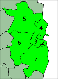
2008年ダブリン交通局法(Dublin Transport Authority Act 2008)では、ダブリン都市圏をダブリン県(ダブリン市、南ダブリン市、ダン・レアリー=ラスダウン市、フィンガル市)、ミーズ県、キルデア県、ウィックロー県を含むと定義している[1]。ダブリン都市圏は正式な政治単位ではない。この用語は、ダブリンの都市部や近郊の町に狭義に適用されることもある。
旧境界線 編集
ダブリンの都市部とその周辺地域は、主にアイルランド警察とアイルランド裁判所に関連した様々な法的文書によって定義されている。しかし、2009年以降、ダブリン首都圏(Dublin Metropolitan Area)の警察部門は、ダブリン都市圏と重なることはなくなり、代わりにダブリン地域との併合となっている。
警察の用法 編集
アイルランド東部のダブリン警視庁が管轄していた区域をダブリン首都圏(Dublin Metropolitan Region)と指していたが、後にアイルランドの国家警察であるアイルランド警察に統合された。ダブリン県の一部(ソーズ周辺の北部を除く)、キルデア県の町リークスリップ、ウィックロー県の町ブレイ、グレイストーンズ、エニスケリーを管轄していた。ソーズはミーズ警察署が管轄していた。2008年に警察部門が地域と県の境界に沿って再編成されたため、この定義は適用されなくなった。2009年現在、ダブリン首都圏はダブリン県との共存関係にある。
リークスリップはキルデア県に移され、新しいリークスリップ地区の地区本部となった[2]。ブレイはウィックロー県に移され、ブレイ地区の地区本部となった[3]。
人口 編集
2016年国勢調査時点のダブリン県(ダブリン、フィンガル、南ダブリン、ダン・レアリー=ラスダウン)、ダブリン都市圏郊外(ミーズ県、キルデア県、ウィックロー県)の人口は1,904,806人である[4]。これはアイルランドの人口の40.03%に相当する。中央統計局(CSO)が発表した推計によると、2021年には210万人、2026年には240万人に達すると予想されている[5]。過去に発表された全国の人口予測の地域別内訳を基にしており、現在の人口動態が継続することを前提としている。
また、CSOは、ダブリン市とその郊外を合わせて3つのダブリン地方自治体の中で、より狭義の定義を使用している[6]。郊外の境界線は法的に定義されているのではなく、国際連合の勧告に従ってCSOによって描かれ、修正されている[7]。2011年と2016年の国勢調査時点でのダブリン都市圏の人口分布は以下の通り。
| 行政区画 | 人口 | 人口増加 2011年 - 2016年 | |||
|---|---|---|---|---|---|
| 2011年 | 2016年 | ||||
| ダブリン市 | 527,612 | 553,165 | 25,553 | ||
| ダン・レアリー=ラスダウン市 | 206,261 | 217,274 | 11,013 | ||
| フィンガル市 | 273,991 | 296,214 | 22,223 | ||
| 南ダブリン市 | 265,205 | 278,749 | 13,544 | ||
| ダブリン県 | 1,273,069 | 1,345,402 | 72,333 | ||
| ミーズ県 | 184,135 | 194,942 | 10,807 | ||
| キルデア県 | 210,312 | 222,130 | 11,818 | ||
| ウィックロウ県 | 136,640 | 142,332 | 5,692 | ||
| ミーズ・キルデア・ウィックロウ | 531,087 | 559,404 | 28,317 | ||
| ダブリン都市圏 | 1,804,156 | 1,904,806 | 100,650 | ||
過去 編集
| 国勢調査年 | 人口 | 人口の推移
前回の国勢調査比べ |
割合
人口の割合 | |
|---|---|---|---|---|
| 1841年 | 683,232 | ? | 10.5% | |
| 1851年 | 740,597 | 57,365 | 10年 | 14.5% |
| 1861年 | 698,050 | 42,547 | 10年 | 15.9% |
| 1871年 | 663,131 | 34,919 | 10年 | 16.4% |
| 1881年 | 652,569 | 10,562 | 10年 | 16.9% |
| 1891年 | 628,539 | 24,030 | 10年 | 18.1% |
| 1901年 | 640,093 | 11,554 | 10年 | 19.9% |
| 1911年 | 669,625 | 29,532 | 10年 | 21.3% |
| 1926年 | 685,242 | 15,617 | 15年 | 23.1% |
| 1936年 | 774,791 | 89,549 | 10年 | 26.1% |
| 1946年 | 827,725 | 52,934 | 10年 | 28.0% |
| 1961年 | 906,347 | 78,622 | 15年 | 32.2% |
| 1971年 | 1,062,220 | 155,873 | 10年 | 35.7% |
| 1981年 | 1,290,154 | 227,934 | 10年 | 37.5% |
| 1986年 | 1,336,119 | 45,965 | 5年 | 37.8% |
| 1991年 | 1,350,595 | 14,476 | 5年 | 38.3% |
| 1996年 | 1,405,671 | 55,076 | 5年 | 38.8% |
| 2002年 | 1,535,446 | 129,775 | 6年 | 39.2% |
| 2006年 | 1,662,536 | 127,090 | 4年 | 39.2% |
| 2011年 | 1,801,040 | 138,504 | 5年 | 39.3% |
| 2016年 | 1,904,806 | 103,766 | 5年 | 40.0% |
脚注 編集
出典 編集
- ^ “Section 3 of Dublin Transport Authority Act 2008” (英語). electronic Irish Statute Book (eISB). 2020年9月2日閲覧。
- ^ “New 24-hour Leixlip garda station opens - Local - Leinster Leader”. archive.is (2013年2月17日). 2020年9月21日閲覧。
- ^ “Bray to become Garda HQ for County Wicklow” (英語). independent. 2020年9月21日閲覧。
- ^ “Population of each Province, County and City, 2016”. CSO.ie. 中央統計局. 2016年7月16日閲覧。
- ^ “Regional Population Projections 2016 - 2031 - CSO - Central Statistics Office” (英語). www.cso.ie. 2020年9月21日閲覧。
- ^ “Appendix 2: Dublin Area”. Census 2006 Volume 1 – Population Classified by Area: Appendices. 中央統計局. (26 April 2007). p. 164. オリジナルの27 September 2007時点におけるアーカイブ。 2007年9月15日閲覧. "The description Greater Dublin Area in the 2006 Census denotes Dublin City and its suburbs"
- ^ Central Statistics Office (Ireland) (26 April 2007). Census 2006 Volume 1 – Population Classified by Area: Appendices. Appendix 2, p.163: Towns (i) Towns with Legally Defined Boundaries. "where urban areas have extended beyond the legally defined town boundary, the Central Statistics Office draws up new boundaries defining the suburban areas of Cities/Boroughs ... for census purposes ... in conformity with United Nations recommendations, as the continuation of a distinct population cluster outside its legally defined boundary in which no occupied dwelling is more than 200 metres distant from the nearest occupied dwelling ... The suburban boundaries were reviewed for each subsequent census. A comprehensive review was carried out as part of the processing phase of the 2006 Census."
- ^ Central Statistics Office – Census of Population Database