ファイル:1752 Schely Plan or Map of Edo or Tokyo, Japan - Geographicus - EdoTokyo-schley-1752.jpg

元のファイル(2,500 × 2,461 ピクセル、ファイルサイズ: 1.96メガバイト、MIME タイプ: image/jpeg)

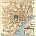
Plan de Jedo.
作者
タイトル
Plan de Jedo.
解説
English: This is an attractive and highly desirable c. 1752 map of Edo or Tokyo, Japan. Issued by Bellin and Schley for Prevost's Histoire Generale des Voyages , this map is cartographically based on a 1702 map of the same issued by Scheuchzer and Kaempfer, which itself is most likely based on Japanese maps. Centered on Edo Castle, this map depicts the whole of Edo as it existed, with numerous street shown but not named. Edo Castle itself is fancifully depicted as a French style formal garden. Possibly due to the cartographers inability to translate Japanese, the only three named locations on the map are Edo Castle, Japan Bridge, and the Faubourg de Sinagawa. Here, in Sinagawa, the Tokugawa Shogunate maintained the Suzugamori Execution grounds where traitors to the state, criminals, and Christians were executed in an effort to contain spiritual pollution. Drawn by N. Bellin and Schley for Abbe Prevost's Histoire Generale des Voyages .
日付 1752年 (undated)
寸法 高さ: 10 in (25.4 cm);幅: 10 in (25.4 cm)
dimensions QS:P2048,10U218593
dimensions QS:P2049,10U218593
台帳番号
Geographicus link: EdoTokyo-schley-1752
情報源/撮影者

Provost, A. A., Prevost's Histoire Generale des Voyages, c. 1752.

許可
(ファイルの再利用)
このファイルは、パブリックドメインの状態にある平面的な美術の著作物を写真術によって忠実に複製したものです。このような複製はアメリカ合衆国においてパブリックドメインの状態にあります。その他の地域では再利用に制限がかかる場合があります。詳しくはReuse of PD-Art photographsをご覧ください。美術の著作物としての原図は、次の理由によりパブリックドメインの状態にあります。
Public domain

この著作物は、著作権の保護期間が著作者の死後100年以下である国・地域においてパブリックドメインの状態にあります。


この著作物がアメリカ合衆国においてパブリックドメインの状態にあることを示すために、アメリカ合衆国のPDタグも貼る必要があります。

キャプション

このファイルの内容を1行で記述してください

このファイルに描写されている項目

題材

6d028dc37003c4bbd5174c907d109a0331152aa7

2,055,040 バイト

2,461 ピクセル

2,500 ピクセル

ファイルの履歴

過去の版のファイルを表示するには、その版の日時をクリックしてください。

日付と時刻サムネイル寸法利用者コメント
現在の版2011年3月24日 (木) 12:492011年3月24日 (木) 12:49時点における版のサムネイル2,500 × 2,461 (1.96メガバイト)BotMultichillT{{subst:User:Multichill/Geographicus |link=http://www.geographicus.com/P/AntiqueMap/EdoTokyo-schley-1752 |product_name=1752 Schely Plan or Map of Edo or Tokyo, Japan |map_title=Plan de Jedo. |description=This is an attractive and highly desirable c. 1752

以下の​ 2 ページがこのファイルを使用しています:

グローバルなファイル使用状況

以下に挙げる他のウィキがこの画像を使っています:

  • zh.wikipedia.org での使用状況