ファイル:1794 Anville Map of the Ancient World - Geographicus - AncientWorld-anville-1794.jpg

このプレビューのサイズ: 800 × 579 ピクセル。 その他の解像度: 320 × 232 ピクセル | 640 × 463 ピクセル | 1,024 × 741 ピクセル | 1,280 × 926 ピクセル | 2,560 × 1,852 ピクセル | 5,000 × 3,618 ピクセル。
元のファイル (5,000 × 3,618 ピクセル、ファイルサイズ: 4.69メガバイト、MIME タイプ: image/jpeg)
ウィキメディア・コモンズのファイルページにある説明を、以下に表示します。
|
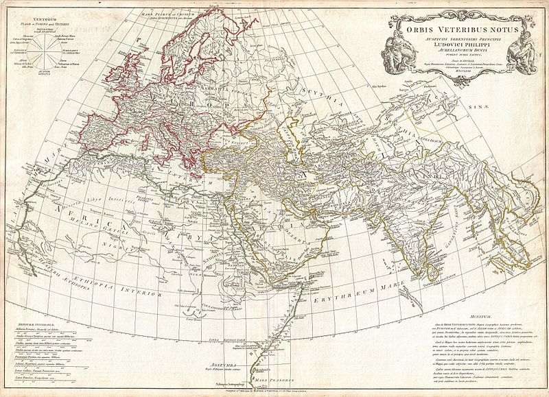
| ダンヴィユ: Orbis Veteribus Notus.
( |
||||||
|---|---|---|---|---|---|---|
| 作者 | ||||||
| タイトル |
Orbis Veteribus Notus. |
|||||
| 解説 |
English: A large and dramatic composite 1794 map of the world as it was known to the ancients, by J. B. B. D'Anville. Covers all of Europe, Asia Minor, Arabia and India, much of Northern Africa, and parts of Southeast Asia. D'Anville compiled this map from various sources including Ptolemy, Herodotus, Thucydides, and others. In Africa, the author notes various cities from Ptolemy's Geographica , including Rapta, Axum, Garama, and others. Includes the Mountains of the Moon, Lakes of the Nile, and other conjectural destinations. Far in the south a note reads, Aethiopes Anthropophagi, which essentially translates to African Cannibals. In the Far East a number of classical locals are noted, including the island of Taprobana (Celon) and the empires of Southeast Asia. Details mountains, rivers, cities, roadways, and lakes with political divisions highlighted in outline color. Title cartouche appears in a baroque frame in the upper left quadrant. Cartouche is flanked on either side by malignant appearing figure with a telescope and a studious scholar reading a book. Includes eight distance scales, bottom left, referencing various measurement systems common in antiquity. Text in Latin and English. Drawn by J. B. B. D'Anville in 1762 and published in 1794 by Laurie and Whittle, London. |
|||||
| 日付 | dated 1763, published 1794 | |||||
| 寸法 | 高さ: 21 in (53.3 cm);幅: 30 in (76.2 cm) | |||||
| 台帳番号 |
Geographicus link: AncientWorld-anville-1794 |
|||||
| 情報源/撮影者 |
D'Anville, J. B. B., Complete Body of Ancient Geography, Laurie and Whittle, London, 1795.
|
|||||
| 許可 (ファイルの再利用) |
|
|||||

ファイルの履歴
過去の版のファイルを表示するには、その版の日時をクリックしてください。
| 日付と時刻 | サムネイル | 寸法 | 利用者 | コメント | |
|---|---|---|---|---|---|
| 現在の版 | 2011年3月23日 (水) 14:35 | | 5,000 × 3,618 (4.69メガバイト) | BotMultichillT | {{subst:User:Multichill/Geographicus |link=http://www.geographicus.com/P/AntiqueMap/AncientWorld-anville-1794 |product_name=1794 Anville Map of the Ancient World |map_title=Orbis Vetribus Notus. |description=A large and dramatic composite 1794 map of the |
ファイルの使用状況
以下のページがこのファイルを使用しています:
グローバルなファイル使用状況
以下に挙げる他のウィキがこの画像を使っています:
- fa.wikipedia.org での使用状況
- fa.wikibooks.org での使用状況
- hr.wikipedia.org での使用状況
- pt.wikipedia.org での使用状況
- ru.wikipedia.org での使用状況
- sh.wikipedia.org での使用状況
- tr.wikipedia.org での使用状況