ファイル:ACW Chattanooga2Carolinas.png
このプレビューのサイズ: 800 × 426 ピクセル。 その他の解像度: 320 × 170 ピクセル | 640 × 341 ピクセル | 1,024 × 545 ピクセル | 1,881 × 1,002 ピクセル。
元のファイル (1,881 × 1,002 ピクセル、ファイルサイズ: 429キロバイト、MIME タイプ: image/png)
ウィキメディア・コモンズのファイルページにある説明を、以下に表示します。
|
概要
| 解説 |
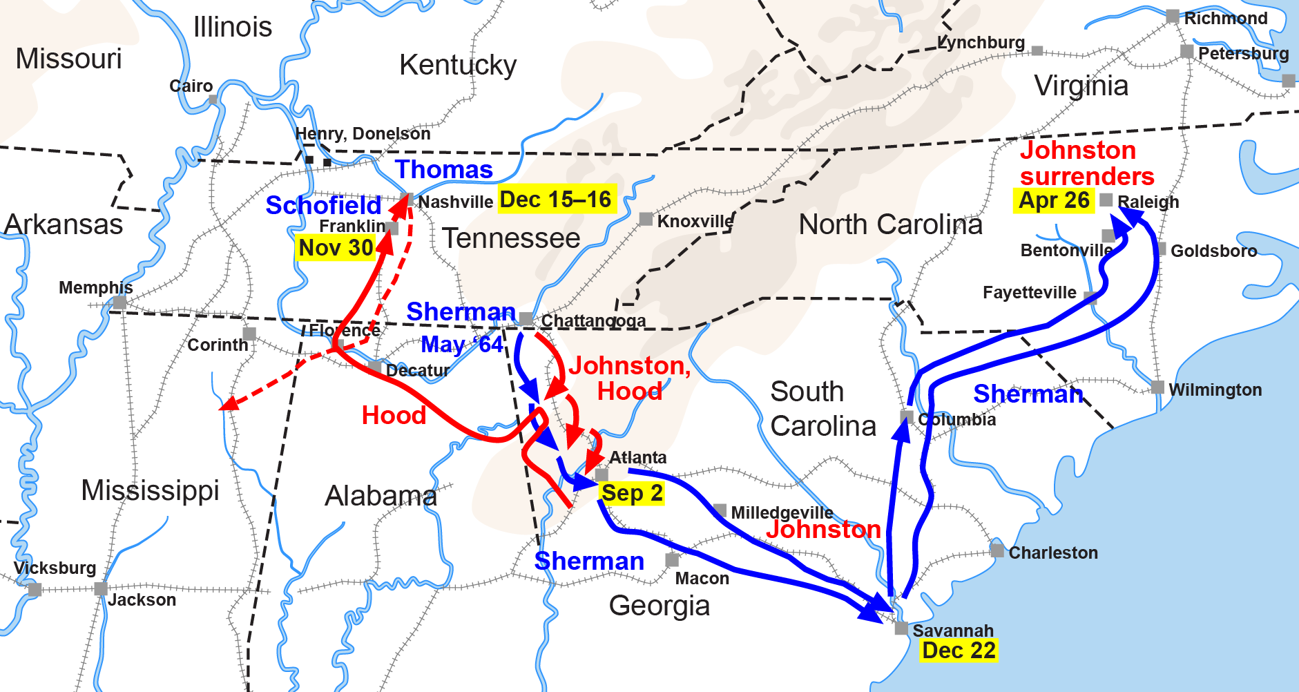
English: Map of the Western Theater of the American Civil War, actions from Chattanooga to the Carolinas. |
| 日付 | |
| 原典 | Drawn by Hal Jespersen in Adobe Illustrator CS5. Graphic source file is available at http://www.posix.com/CWmaps/ |
| 作者 | 英語版ウィキペディアのHljさん |
| その他のバージョン |
|


ライセンス
このファイルはクリエイティブ・コモンズ 表示 3.0 非移植ライセンスのもとに利用を許諾されています。
帰属: Map by Hal Jespersen, www.posix.com/CW
- あなたは以下の条件に従う場合に限り、自由に
- 共有 – 本作品を複製、頒布、展示、実演できます。
- 再構成 – 二次的著作物を作成できます。
- あなたの従うべき条件は以下の通りです。
- 表示 – あなたは適切なクレジットを表示し、ライセンスへのリンクを提供し、変更があったらその旨を示さなければなりません。これらは合理的であればどのような方法で行っても構いませんが、許諾者があなたやあなたの利用行為を支持していると示唆するような方法は除きます。
元のアップロードログ
it.wikipedia からコモンズに MaEr によって移動されました。
元のファイルページはこちら。以下の利用者は全てit.wikipediaに属します。
- 2006-10-06 17:12 Starlight 1566×773×??? (316548 bytes) Map of the Western Theater of the American Civil War, actions from Chattanooga to the Carolinas. Drawn by Hal Jespersen in Macromedia Freehand. Graphic source file is available at http://www.posix.com/CWmaps/ {{PD}}
元のファイルページはこちら。以下の利用者は全てen.wikipediaに属します。
- 2006-03-31 00:30 Hlj 1566×773× (316548 bytes) Map of the [[Western Theater of the American Civil War]], actions from Chattanooga to the Carolinas. Drawn by Hal Jespersen in Macromedia Freehand. Graphic source file is available at http://www.posix.com/CWmaps/ {{PD-release}}
ファイルの履歴
過去の版のファイルを表示するには、その版の日時をクリックしてください。
| 日付と時刻 | サムネイル | 寸法 | 利用者 | コメント | |
|---|---|---|---|---|---|
| 現在の版 | 2011年3月24日 (木) 22:35 | | 1,881 × 1,002 (429キロバイト) | Hlj | Update to new graphical style for rivers. Same license. |
| 2009年2月6日 (金) 05:34 |  | 1,862 × 992 (309キロバイト) | Hlj | {{Information |Description=Map of Sherman's operations from Chattanooga through the Carolinas of the American Civil War. (Minor updates from previous version; new license.) Drawn in Adobe Illustrator CS3 by Hal Jespersen. Graphic source file is availa | |
| 2008年9月14日 (日) 11:50 |  | 1,566 × 773 (309キロバイト) | MaEr | {{Information |Description={{en|Map of the Western Theater of the American Civil War, actions from Chattanooga to the Carolinas. Drawn by Hal Jespersen in Macromedia Freehand. Graphic source file is available at http://www.posix.com/CWmaps/}} |Source=Tran |
ファイルの使用状況
以下のページがこのファイルを使用しています:
グローバルなファイル使用状況
以下に挙げる他のウィキがこの画像を使っています:
- en.wikipedia.org での使用状況
- fr.wikipedia.org での使用状況
- it.wikipedia.org での使用状況
- ru.wikipedia.org での使用状況
- uk.wikipedia.org での使用状況