ファイル:Amazonie deforestation.jpg
このプレビューのサイズ: 755 × 600 ピクセル。 その他の解像度: 302 × 240 ピクセル | 604 × 480 ピクセル | 778 × 618 ピクセル。
元のファイル (778 × 618 ピクセル、ファイルサイズ: 398キロバイト、MIME タイプ: image/jpeg)
ウィキメディア・コモンズのファイルページにある説明を、以下に表示します。
|
概要
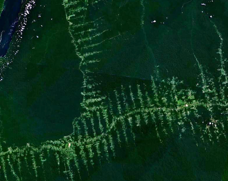
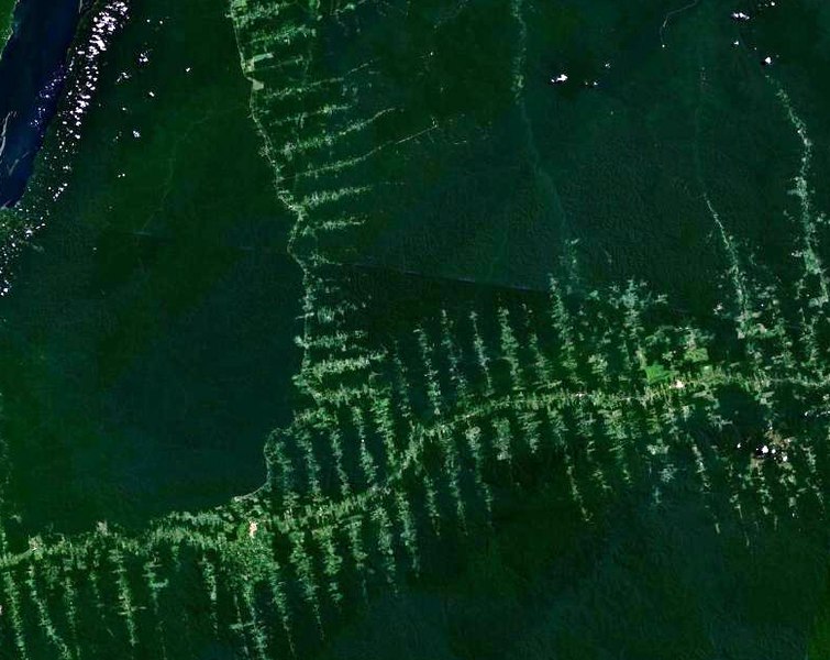
English: Deforestation in Amazonia, seen from satellite. The roads in the forest follow a typical "fish bone" pattern
Français : Déforestation en Amazonie, vu depuis un satellite. Les routes tracées dans la forêt suivent un motif caractéristique similaire à des arêtes de poisson
Deutsch: Entwaldung in Amazonien, aufgenommen vom Satelliten. Die in den Wald getriebenen Schneisen ergeben ein charakteristisches Fischgrätenmuster
ライセンス
| このファイルはアメリカ航空宇宙局(NASA)によって作成されたものです。NASAの著作権の方針では、特記事項が無い場合、NASAの資料はパブリックドメインとなります。 (詳しくはTemplate:PD-USGov、NASAの著作権の方針について(英語)又はジェット推進研究所(JPL)の画像使用に関するガイドライン(英語)をご覧ください。) |
||
 |
注意事項:
|
ファイルの履歴
過去の版のファイルを表示するには、その版の日時をクリックしてください。
| 日付と時刻 | サムネイル | 寸法 | 利用者 | コメント | |
|---|---|---|---|---|---|
| 現在の版 | 2006年9月20日 (水) 20:02 | | 778 × 618 (398キロバイト) | Dake~commonswiki | {{en|Deforestation in Amazonia, seen from satellite. The roads in the forest follow a typical "fishbone" pattern}} {{fr|Déforestation en Amazonie, vu depuis un satellite. Les routes tracées dans la forêt suivent un motif caractéristique similaire à |
ファイルの使用状況
以下のページがこのファイルを使用しています:
グローバルなファイル使用状況
以下に挙げる他のウィキがこの画像を使っています:
- ar.wikipedia.org での使用状況
- bn.wikipedia.org での使用状況
- ca.wikipedia.org での使用状況
- chr.wikipedia.org での使用状況
- de.wikipedia.org での使用状況
- el.wikipedia.org での使用状況
- en.wikipedia.org での使用状況
- eo.wikipedia.org での使用状況
- es.wikipedia.org での使用状況
- eu.wikipedia.org での使用状況
- fr.wikipedia.org での使用状況
- gu.wikipedia.org での使用状況
- id.wikipedia.org での使用状況
- nl.wikipedia.org での使用状況
- pa.wikipedia.org での使用状況
- pl.wikipedia.org での使用状況
- pt.wikipedia.org での使用状況
- ro.wikipedia.org での使用状況
- ru.wikipedia.org での使用状況
- sl.wikipedia.org での使用状況
- sq.wikipedia.org での使用状況
- ta.wikipedia.org での使用状況
- tr.wikipedia.org での使用状況
- vi.wikipedia.org での使用状況