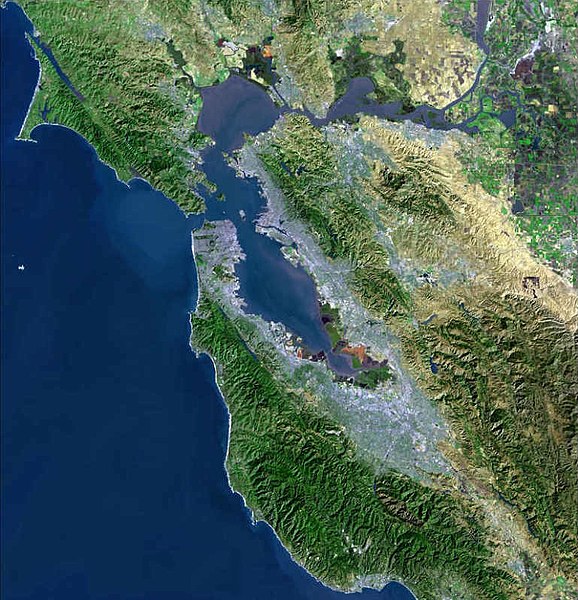
ファイル:BayareaUSGS.jpg

このプレビューのサイズ: 578 × 600 ピクセル。 その他の解像度: 231 × 240 ピクセル | 463 × 480 ピクセル | 769 × 798 ピクセル。
元のファイル (769 × 798 ピクセル、ファイルサイズ: 613キロバイト、MIME タイプ: image/jpeg)
ファイルの履歴
過去の版のファイルを表示するには、その版の日時をクリックしてください。
| 日付と時刻 | サムネイル | 寸法 | 利用者 | コメント | |
|---|---|---|---|---|---|
| 現在の版 | 2009年4月19日 (日) 00:08 |  | 769 × 798 (613キロバイト) | Yarnalgo | rmving little border on top and right and rmving USGS watermark |
| 2006年12月22日 (金) 15:14 |  | 770 × 800 (98キロバイト) | Nk | Satellite map of the San Francisco Bay Area from the U.S. Geological Survey. The effect of the San Andreas Fault on the terrain can been seen on a diagonal line from the upper left corner to the lower right. The green and golden mountainous regions (wri |
ファイルの使用状況
以下の 5 ページがこのファイルを使用しています:
グローバルなファイル使用状況
以下に挙げる他のウィキがこの画像を使っています:
- ar.wikipedia.org での使用状況
- سان فرانسيسكو
- سان خوسيه (كاليفورنيا)
- مقاطعة ألاميدا (كاليفورنيا)
- مقاطعة كونترا كوستا (كاليفورنيا)
- مقاطعة مارين (كاليفورنيا)
- مقاطعة نابا (كاليفورنيا)
- مقاطعة سان ماتيو (كاليفورنيا)
- مقاطعة سانتا كلارا (كاليفورنيا)
- مقاطعة سولانو (كاليفورنيا)
- مقاطعة سونوما (كاليفورنيا)
- ستانفورد (كاليفورنيا)
- فاليجو (كاليفورنيا)
- نابا (كاليفورنيا)
- أوكلاند (كاليفورنيا)
- فريمونت (كاليفورنيا)
- هايوارد (كاليفورنيا)
- سان ماتيو (كاليفورنيا)
- ريدوود (كاليفورنيا)
- سانيفال (كاليفورنيا)
- سانتا كلارا (كاليفورنيا)
- سانتا روسا (كاليفورنيا)
- بيتالوما
- فيرفيلد (كاليفورنيا)
- مارتينز (كاليفورنيا)
- بنيسيا (كاليفورنيا)
- ريتشموند (كاليفورنيا)
- سان رافاييل (كاليفورنيا)
- أنتيوك
- منطقة خليج سان فرانسيسكو
- خليج سان فرانسيسكو
- ألاميدا (كاليفورنيا)
- ألباني (كاليفورنيا)
- أميريكان كانيون (كاليفورنيا)
- بيلمونت (كاليفورنيا)
- بيركيلي (كاليفورنيا)
- برينتوود (كاليفورنيا)
- بورلينغامي (كاليفورنيا)
- كامببيل (كاليفورنيا)
- كلايتون (كاليفورنيا)
- كونكورد (كاليفورنيا)
- كوبيرتينو (كاليفورنيا)
- دالي سيتي (كاليفورنيا)
- دانفيل (كاليفورنيا)
- ديكسون (كاليفورنيا)
- دوبلين (كاليفورنيا)
- إيست بالو ألتو (كاليفورنيا)
- إل سيرريتو (كاليفورنيا)
- إميريفيلي (كاليفورنيا)
- فوستير سيتي (كاليفورنيا)
- غيلروي (كاليفورنيا)
このファイルのグローバル使用状況を表示する。
