ファイル:Beaver wars map.jpg

このプレビューのサイズ: 710 × 600 ピクセル。 その他の解像度: 284 × 240 ピクセル | 568 × 480 ピクセル | 871 × 736 ピクセル。
元のファイル (871 × 736 ピクセル、ファイルサイズ: 163キロバイト、MIME タイプ: image/jpeg)
ウィキメディア・コモンズのファイルページにある説明を、以下に表示します。
|
| 解説 |
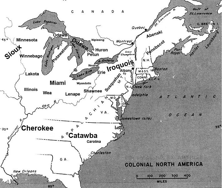
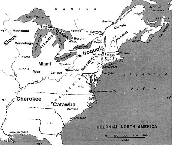
English: Map of the location of major tribes involved in the Beaver Wars laid against a period map showing colonial settlments |
||
| 日付 | |||
| 原典 | 投稿者自身による著作物 | ||
| 作者 | Charles Edward | ||
| 許可 (ファイルの再利用) |
|
Info
This represents the approximate configuration of the tribes in 1648. Although the areas are large, the populations were low and large parts of the territories where uninhabited, and instead used as hunting grounds. The tribes were also semi nomadic, and the period was rife with war and several of the tribes on the map were destroyed in the 1650s. The map was made using information in several books incluing:
- Jennings, Francis (1984年) The Ambiguous Iroquois Empire ISBN: 0393017192.
- Wallace, Paula W (2007年) Indians in Pennsylvania、DIANE Publishing Inc ISBN: 1422314936.
ファイルの履歴
過去の版のファイルを表示するには、その版の日時をクリックしてください。
| 日付と時刻 | サムネイル | 寸法 | 利用者 | コメント | |
|---|---|---|---|---|---|
| 現在の版 | 2008年11月18日 (火) 22:34 | | 871 × 736 (163キロバイト) | Charles Edward | Slight adjustment to name on image |
| 2008年11月18日 (火) 22:33 |  | 871 × 736 (164キロバイト) | Charles Edward | {{Information |Description=adjustment of locations per discussion on Beaver War talk page |Source= |Date= |Author= |Permission= |other_versions= }} | |
| 2008年11月16日 (日) 19:51 |  | 871 × 736 (298キロバイト) | Charles Edward | {{Information |Description=New version removes borders, ads more ambiguity to the map |Source= |Date= |Author= |Permission= |other_versions= }} | |
| 2008年11月16日 (日) 02:43 |  | 815 × 472 (275キロバイト) | Charles Edward | {{Information |Description= |Source= |Date= |Author= |Permission= |other_versions= }} | |
| 2008年11月16日 (日) 01:16 |  | 815 × 472 (275キロバイト) | Charles Edward | {{Information |Description=adding tribes, adjusting locations |Source= |Date= |Author= |Permission= |other_versions= }} Category:Maps of the United States | |
| 2008年11月16日 (日) 00:39 |  | 815 × 472 (270キロバイト) | Charles Edward | {{Information |Description=Added additional tribes |Source= |Date= |Author= |Permission= |other_versions= }} | |
| 2008年11月16日 (日) 00:35 |  | 815 × 472 (270キロバイト) | Charles Edward | {{Information |Description=Added additional tribes |Source= |Date= |Author= |Permission= |other_versions= }} | |
| 2008年11月16日 (日) 00:14 |  | 815 × 472 (262キロバイト) | Charles Edward | {{Information |Description={{en|1=Map of the location of major tribes involved in the Beaver Wars laid against a period map showing colonial settlments}} |Source=Own work by uploader |Author=Charles Edward |Date=11-15-8 |Permission |
ファイルの使用状況
以下のページがこのファイルを使用しています:
グローバルなファイル使用状況
以下に挙げる他のウィキがこの画像を使っています:
- azb.wikipedia.org での使用状況
- cs.wikipedia.org での使用状況
- en.wikipedia.org での使用状況
- es.wikipedia.org での使用状況
- et.wikipedia.org での使用状況
- gl.wikipedia.org での使用状況
- id.wikipedia.org での使用状況
- it.wikipedia.org での使用状況
- lv.wikipedia.org での使用状況
- nl.wikipedia.org での使用状況
- no.wikipedia.org での使用状況
- pl.wikipedia.org での使用状況