ファイル:BritishEmpire1919.png
このプレビューのサイズ: 800 × 409 ピクセル。 その他の解像度: 320 × 163 ピクセル | 640 × 327 ピクセル | 1,425 × 728 ピクセル。
元のファイル (1,425 × 728 ピクセル、ファイルサイズ: 52キロバイト、MIME タイプ: image/png)
ウィキメディア・コモンズのファイルページにある説明を、以下に表示します。
|

|
このhistorical map画像は、ベクターイメージである SVG ファイルとして再作成されるべきです。これにはいくつかの利点があります。詳しくはCommons:Media for cleanupを参照してください。この画像の SVG 形式がすでに利用可能である場合は、アップロードしてください。アップロード後、この画像にあるこのテンプレートを{{Vector version available|新しい画像ファイル名.svg}}テンプレートで置き換えてください。
|
概要
| 解説 |
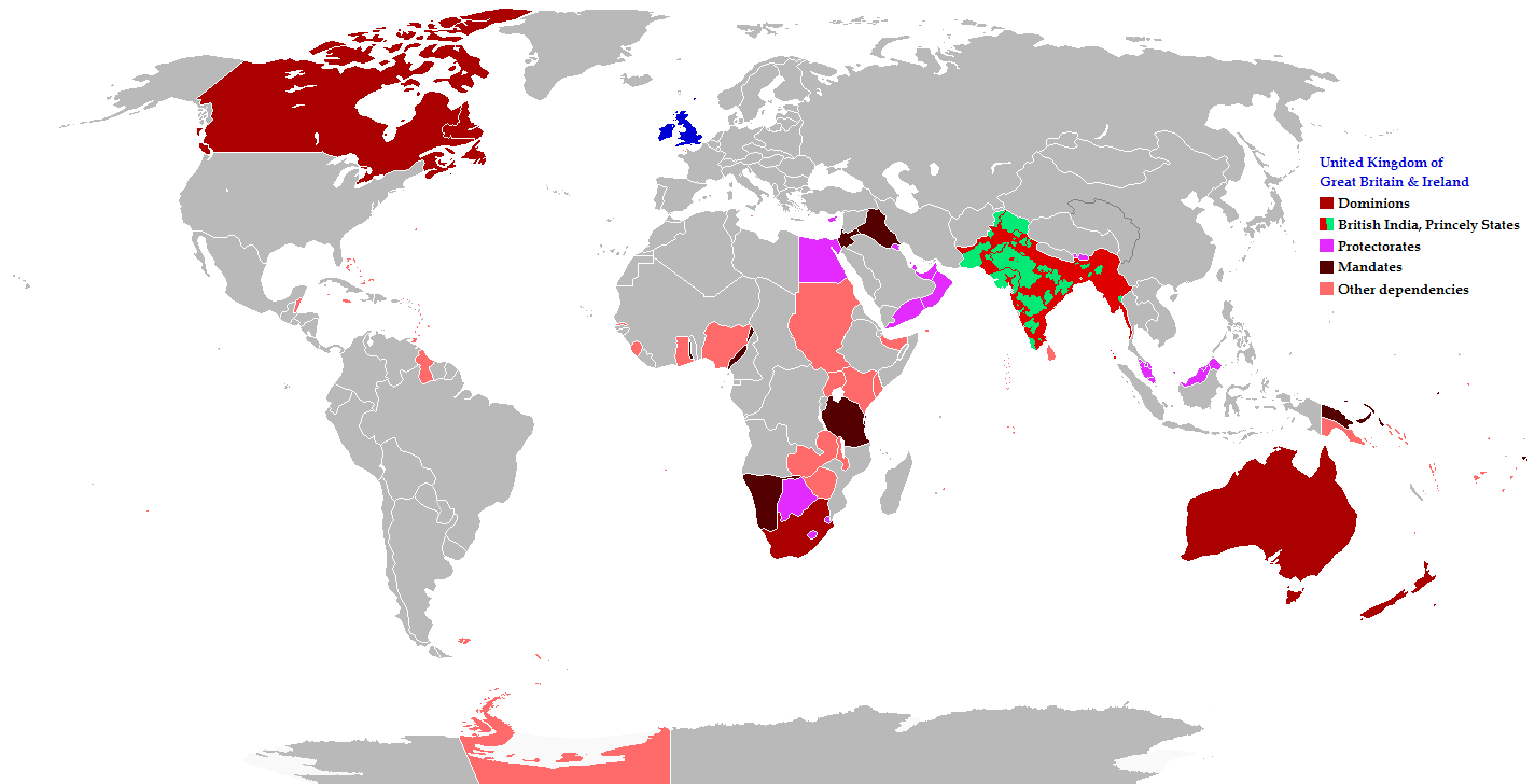
English: Map of the British Empire in 1919 showing all the territories, including the dominions, colonies, protectorates and mandates, ruled or administered by the United Kingdom and its successor states during that year.
Français : Carte de l'Empire britannique en 1919 illustrant tous les territoires, tels que les dominions, colonies, protectorats et mandats, gouvernés ou administrés par le Royaume-Uni ou ses États successeurs cette année-là.
Español: Un mapa de todas las afirmaciones oficiales territorial del Imperio Británico que se celebró en 1919 que identifica qué tipo de celebración estaba presente en todas las posesiones durante ese año.
Deutsch: Eine Karte aller offiziellen territorialen Ansprüche des Britischen Empire, die es im Jahre 1919 hatte, nach Art der Besitzungen in diesem Jahr.
فارسی: نقشه بیمورد از همه ادعاهای ارضی رسمی امپراطوری بریتانیا که در سال 1919 که برای شناسایی نوع برگزاری در حال حاضر تمام اموال در آن سال برگزار شد.
Português: Mapa de todos os territórios reclamados pelo Império Britânico, em 1919, que identifica o tipo de presença britânica no local naquele ano. |
| 日付 | |
| 原典 |
The following: |
| 作者 | Maps & Lucy |
| 許可 (ファイルの再利用) |
Released into the public domain (by the author). |
| その他のバージョン | العربيَّة |
Legend
Deutsch (de):
ライセンス
このファイルはクリエイティブ・コモンズ 表示-継承 2.5 一般ライセンスのもとに利用を許諾されています。
- あなたは以下の条件に従う場合に限り、自由に
- 共有 – 本作品を複製、頒布、展示、実演できます。
- 再構成 – 二次的著作物を作成できます。
- あなたの従うべき条件は以下の通りです。
- 表示 – あなたは適切なクレジットを表示し、ライセンスへのリンクを提供し、変更があったらその旨を示さなければなりません。これらは合理的であればどのような方法で行っても構いませんが、許諾者があなたやあなたの利用行為を支持していると示唆するような方法は除きます。
- 継承 – もしあなたがこの作品をリミックスしたり、改変したり、加工した場合には、あなたはあなたの貢献部分を元の作品とこれと同一または互換性があるライセンスの下に頒布しなければなりません。
ファイルの履歴
過去の版のファイルを表示するには、その版の日時をクリックしてください。
| 日付と時刻 | サムネイル | 寸法 | 利用者 | コメント | |
|---|---|---|---|---|---|
| 現在の版 | 2021年10月31日 (日) 08:26 | | 1,425 × 728 (52キロバイト) | Randomastwritter | jubaland |
| 2014年11月17日 (月) 20:43 |  | 1,425 × 728 (61キロバイト) | GrenaderGD44 | Убраны артефакты с карты в районе Антарктиды | |
| 2014年11月17日 (月) 01:40 |  | 1,425 × 728 (65キロバイト) | GrenaderGD44 | Бутан - протекторат с 1910 года | |
| 2014年3月9日 (日) 18:36 |  | 1,425 × 625 (39キロバイト) | Htonl | Bechuanaland, Basutoland and Swaziland were protectorates | |
| 2011年6月18日 (土) 20:02 |  | 1,425 × 625 (55キロバイト) | Maps & Lucy | The British Empire, Mongolia and the Soviet Union all recognized Tibet as an independent state and the British Empire via British India were heavily involved in Tibet's independence. | |
| 2011年5月7日 (土) 19:05 |  | 1,425 × 625 (58キロバイト) | Quigley | Correct China's borders closer to what was internationally recognized at the time | |
| 2010年12月15日 (水) 23:55 |  | 1,425 × 625 (55キロバイト) | Maps & Lucy | Added protectorates and Princely States | |
| 2010年12月10日 (金) 22:47 |  | 1,425 × 625 (53キロバイト) | Maps & Lucy | Papua was a colony not a dominion, Gold Coast did not include British Togoland and British Togoland was a mandate. | |
| 2010年11月7日 (日) 18:20 |  | 1,425 × 625 (59キロバイト) | Spesh531 | fix mistake in botswana | |
| 2010年11月7日 (日) 18:19 |  | 1,425 × 625 (56キロバイト) | Spesh531 | really a way to revert. use this version |
ファイルの使用状況
以下のページがこのファイルを使用しています:
グローバルなファイル使用状況
以下に挙げる他のウィキがこの画像を使っています:
- af.wikipedia.org での使用状況
- ar.wikipedia.org での使用状況
- azb.wikipedia.org での使用状況
- az.wikipedia.org での使用状況
- ba.wikipedia.org での使用状況
- be-tarask.wikipedia.org での使用状況
- be.wikipedia.org での使用状況
- bg.wikipedia.org での使用状況
- bs.wikipedia.org での使用状況
- bxr.wikipedia.org での使用状況
- cdo.wikipedia.org での使用状況
- de.wikipedia.org での使用状況
- el.wikipedia.org での使用状況
- en.wikipedia.org での使用状況
- eo.wikipedia.org での使用状況
- fiu-vro.wikipedia.org での使用状況
- fi.wikipedia.org での使用状況
- fr.wikipedia.org での使用状況
- he.wikipedia.org での使用状況
- hif.wikipedia.org での使用状況
- hr.wikipedia.org での使用状況
- hy.wikipedia.org での使用状況
- ia.wikipedia.org での使用状況
- id.wikipedia.org での使用状況
- is.wikipedia.org での使用状況
- kk.wikipedia.org での使用状況
- krc.wikipedia.org での使用状況
- lez.wikipedia.org での使用状況
- lo.wikipedia.org での使用状況
- lv.wikipedia.org での使用状況
- ms.wikipedia.org での使用状況
- mwl.wikipedia.org での使用状況
- my.wikipedia.org での使用状況
- nl.wikipedia.org での使用状況
- nn.wikipedia.org での使用状況
- pnb.wikipedia.org での使用状況
- qu.wikipedia.org での使用状況
- ru.wikipedia.org での使用状況
このファイルのグローバル使用状況を表示する。