ファイル:Ctcolony.png

このプレビューのサイズ: 800 × 560 ピクセル。 その他の解像度: 320 × 224 ピクセル | 640 × 448 ピクセル | 1,024 × 717 ピクセル | 1,428 × 1,000 ピクセル。
元のファイル (1,428 × 1,000 ピクセル、ファイルサイズ: 817キロバイト、MIME タイプ: image/png)
ウィキメディア・コモンズのファイルページにある説明を、以下に表示します。
|
概要
| 解説 |
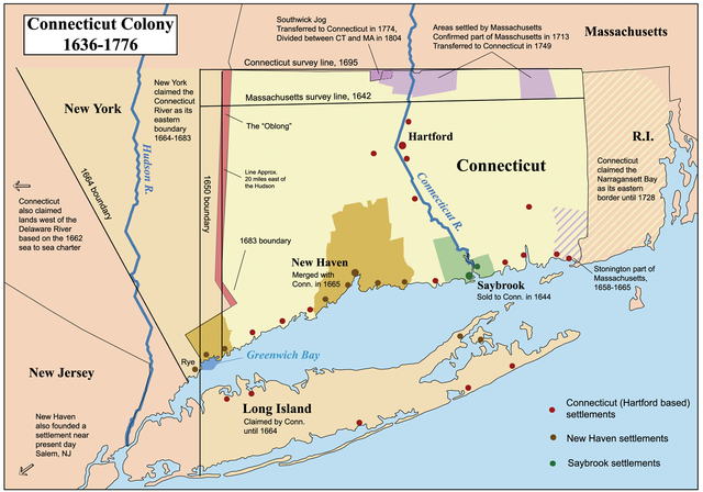
This is a map showing the Connecticut, New Haven, and Saybrook colonies from 1636-1776. It includes the territorial disputes between Connecticut and its neighbors during that time period. It does not show Connecticut's western land claims and dispute with Pennsylvania. Based primarily on descriptions from The Boundary Disputes of Connecticut by Clarence Winthrop Bowen. James R. Osgood and Company, Boston, 1882. |
| 日付 | 2006年10月12日 (当初のアップロード日) |
| 原典 | コンピュータが読み取れる情報は提供されていませんが、投稿者自身による著作物だと推定されます(著作権の主張に基づく) |
| 作者 | コンピュータが読み取れる情報は提供されていませんが、Kmusserだと推定されます(著作権の主張に基づく) |
ライセンス
この作品の著作権者である私は、この作品を以下のライセンスで提供します。
このファイルはクリエイティブ・コモンズ 表示-継承 2.5 一般ライセンスのもとに利用を許諾されています。
- あなたは以下の条件に従う場合に限り、自由に
- 共有 – 本作品を複製、頒布、展示、実演できます。
- 再構成 – 二次的著作物を作成できます。
- あなたの従うべき条件は以下の通りです。
- 表示 – あなたは適切なクレジットを表示し、ライセンスへのリンクを提供し、変更があったらその旨を示さなければなりません。これらは合理的であればどのような方法で行っても構いませんが、許諾者があなたやあなたの利用行為を支持していると示唆するような方法は除きます。
- 継承 – もしあなたがこの作品をリミックスしたり、改変したり、加工した場合には、あなたはあなたの貢献部分を元の作品とこれと同一または互換性があるライセンスの下に頒布しなければなりません。
Format

|
このhistorical map画像は、ベクターイメージである SVG ファイルとして再作成されるべきです。これにはいくつかの利点があります。詳しくはCommons:Media for cleanupを参照してください。この画像の SVG 形式がすでに利用可能である場合は、アップロードしてください。アップロード後、この画像にあるこのテンプレートを{{Vector version available|新しい画像ファイル名.svg}}テンプレートで置き換えてください。
|
ファイルの履歴
過去の版のファイルを表示するには、その版の日時をクリックしてください。
| 日付と時刻 | サムネイル | 寸法 | 利用者 | コメント | |
|---|---|---|---|---|---|
| 現在の版 | 2014年6月2日 (月) 04:06 | | 1,428 × 1,000 (817キロバイト) | JeffyP | I'm here to make the world a little bit smaller ☺ |
| 2008年1月10日 (木) 19:19 |  | 1,428 × 1,000 (909キロバイト) | Kmusser | Major revision to include disputes with Massachusetts and Rhode Island. | |
| 2006年10月12日 (木) 16:54 |  | 800 × 680 (190キロバイト) | Kmusser | == Summary == This is a map showing the Connecticut, New Haven, and Saybrook colonies from 1636-1776. It includes the territorial dispute between Connecticut |
ファイルの使用状況
以下の 5 ページがこのファイルを使用しています:
グローバルなファイル使用状況
以下に挙げる他のウィキがこの画像を使っています:
- bg.wikipedia.org での使用状況
- bn.wikipedia.org での使用状況
- ce.wikipedia.org での使用状況
- da.wikipedia.org での使用状況
- de.wikipedia.org での使用状況
- en.wikipedia.org での使用状況
- Connecticut
- Fishers Island, New York
- New Haven Colony
- History of Connecticut
- Connecticut Colony
- John Haynes (governor)
- Saybrook Colony
- User:Kmusser/Images
- List of colonial governors of Connecticut
- History of Long Island
- New England Colonies
- Portal:Connecticut
- Thomas Powell (American landowner)
- Border disputes between New York and Connecticut
- User:Falcaorib/Canada, United States and Mexico
- en.wikiversity.org での使用状況
- es.wikipedia.org での使用状況
- fr.wikipedia.org での使用状況
- fy.wikipedia.org での使用状況
- he.wikipedia.org での使用状況
- hu.wikipedia.org での使用状況
- hy.wikipedia.org での使用状況
- id.wikipedia.org での使用状況
- it.wikipedia.org での使用状況
- ko.wikipedia.org での使用状況
このファイルのグローバル使用状況を表示する。