ファイル:Egypt-12B-021 - Step Pyramid of Djoser (2217505244).jpg

元のファイル (2,560 × 1,920 ピクセル、ファイルサイズ: 3.36メガバイト、MIME タイプ: image/jpeg)
ウィキメディア・コモンズのファイルページにある説明を、以下に表示します。
|
.jpg?uselang=ja)
.jpg?uselang=ja)
.jpg?uselang=ja&action=history)
.jpg)
概要
| 解説 |
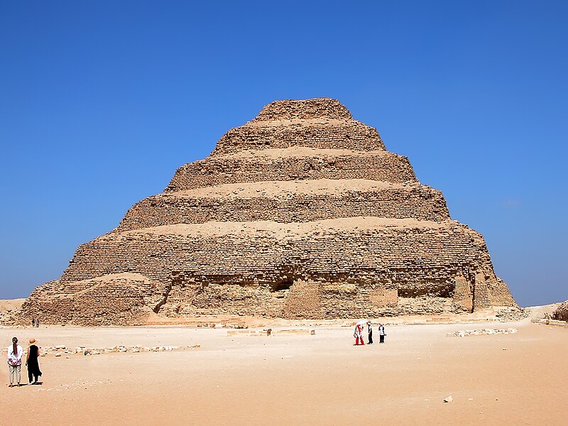
DO NOT SEND ME E-MAIL REQUESTING ME TO LOOK AT A PICTURE, I RETURN ALL COMMENTS IF YOU COMMENT. The Step Pyramid of Djoser is located at Saqqara, just south of Memphis. It started as a mastaba and was expanded six different times to six levels. A mastaba is a type of Ancient Egyptian tomb in the form of a flat-roofed, rectangular structure with outward sloping sides that marked the burial site of many eminent Egyptians of Egypt's ancient period. This pyramid is the earliest stone pyramid in Egypt, thus became an important milestone in Ancient Egyptian Architecture that laid the basis for future and more advanced pyramids in Egypt. The Step Pyramid was already an attraction for many centuries. Evidence has shown that travelers and pilgrims have come to see the pyramid from as early as the Middle Kingdom Period (2040 to 1640 BC). The Step Pyramid of Zoser was built approximately between 2649 to 2575 BC, during the 3rd Dynasty and under the rule of the pharaoh Zoser (or Djoser). The building was under the leadership of the pharaoh’s architect Imhotep. Because of Imhotep’s immense influence and contribution over Ancient Egyptian architecture, he was later deified and became god of the architects and doctors. Special permission from the Antiquities Inspectorate is needed to access the pyramid’s interiors. Original height: 62.198 m (204 ft) Base: 125.27 x 109.11 m (411 x 358 ft) |
| 日付 | |
| 原典 | Egypt-12B-021 - Step Pyramid of Djoser |
| 作者 | Dennis Jarvis from Halifax, Canada |
| 許可 (ファイルの再利用) |
Quote from photographer on numerous files
|
| カメラの位置 | | 以下のサービスでこの位置を確認する: オープンストリートマップ |
|---|
.jpg¶ms=030.069093_N_0031.247863_E_globe:Earth_type:camera_source:Flickr_&language=ja)
ライセンス
- あなたは以下の条件に従う場合に限り、自由に
- 共有 – 本作品を複製、頒布、展示、実演できます。
- 再構成 – 二次的著作物を作成できます。
- あなたの従うべき条件は以下の通りです。
- 表示 – あなたは適切なクレジットを表示し、ライセンスへのリンクを提供し、変更があったらその旨を示さなければなりません。これらは合理的であればどのような方法で行っても構いませんが、許諾者があなたやあなたの利用行為を支持していると示唆するような方法は除きます。
- 継承 – もしあなたがこの作品をリミックスしたり、改変したり、加工した場合には、あなたはあなたの貢献部分を元の作品とこれと同一または互換性があるライセンスの下に頒布しなければなりません。
| この画像は当初、archer10 (Dennis) 116M Views によって Flickr の https://flickr.com/photos/22490717@N02/2217505244 に投稿されたものです。2018-03-01、FlickreviewR 2 ボットによってレビューされ、cc-by-sa-2.0 のライセンスで提供されていることが確認されました。 |
ファイルの履歴
過去の版のファイルを表示するには、その版の日時をクリックしてください。
| 日付と時刻 | サムネイル | 寸法 | 利用者 | コメント | |
|---|---|---|---|---|---|
| 現在の版 | 2018年3月1日 (木) 15:42 | | 2,560 × 1,920 (3.36メガバイト) | Artix Kreiger 2 | Transferred from Flickr via Flickr2Commons |
ファイルの使用状況
以下の 3 ページがこのファイルを使用しています:
.jpg)