ファイル:Global Landslide Risks.jpg
高解像度版はありません。
Global_Landslide_Risks.jpg (540 × 320 ピクセル、ファイルサイズ: 58キロバイト、MIME タイプ: image/jpeg)
ウィキメディア・コモンズのファイルページにある説明を、以下に表示します。
|
概要
| 解説 |
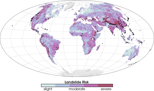
English: Scientists are striving to reduce the loss of life from landslides by developing a global, satellite-based early-warning system. The scientists first identified landslide-prone regions, as shown in this image. To create this landslide risk map scientists mapped all of the regions that featured some combination of coarse soil, land cover that was inadequate to stabilize the surface, and/or steep mountains. The regions that have the highest risk of landslides are salmon pink. Areas of moderate risk are lavender, and regions with a slight risk are pale blue. Areas where landslides occurred between 2003 and 2006 are marked with black dots on this map. |
| 日付 | |
| 原典 | http://earthobservatory.nasa.gov/IOTD/view.php?id=7783 |
| 作者 | Robert Simmon |
Based on measurements recorded by the Tropical Rainfall Measuring Mission (TRMM) satellite.
ライセンス
| このファイルはアメリカ航空宇宙局(NASA)によって作成されたものです。NASAの著作権の方針では、特記事項が無い場合、NASAの資料はパブリックドメインとなります。 (詳しくはTemplate:PD-USGov、NASAの著作権の方針について(英語)又はジェット推進研究所(JPL)の画像使用に関するガイドライン(英語)をご覧ください。) |
||
 |
注意事項:
|
ファイルの履歴
過去の版のファイルを表示するには、その版の日時をクリックしてください。
| 日付と時刻 | サムネイル | 寸法 | 利用者 | コメント | |
|---|---|---|---|---|---|
| 現在の版 | 2009年7月5日 (日) 20:31 | | 540 × 320 (58キロバイト) | Originalwana | {{Information |Description={{en|1=Scientists are striving to reduce the loss of life from landslides by developing a global, satellite-based early-warning system. The scientists first identified landslide-prone regions, as shown in this image. To create t |
ファイルの使用状況
以下のページがこのファイルを使用しています:
グローバルなファイル使用状況
以下に挙げる他のウィキがこの画像を使っています:
- en.wikipedia.org での使用状況
- hu.wikipedia.org での使用状況
- kn.wikipedia.org での使用状況
- ta.wikipedia.org での使用状況
- www.wikidata.org での使用状況