元のファイル(2,400 × 2,400 ピクセル、ファイルサイズ: 1.03メガバイト、MIME タイプ: image/jpeg)

概要

解説
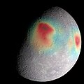
English: Analysis of radio tracking data have enabled maps of the gravity field of Mercury to be derived. In this image, overlain on a mosaic obtained by MESSENGER's Mercury Dual Imaging System and illuminated with a shape model determined from stereo-photoclinometry, Mercury's gravity anomalies are depicted in colors. Red tones indicate mass concentrations, centered on the Caloris basin (center) and the Sobkou region (right limb). Such large-scale gravitational anomalies are signatures of subsurface structure and evolution. The north pole is near the top of the sunlit area in this view. The MESSENGER spacecraft is the first ever to orbit the planet Mercury, and the spacecraft's seven scientific instruments and radio science investigation are unraveling the history and evolution of the Solar System's innermost planet. In the mission's more than four years of orbital operations, MESSENGER has acquired over 250,000 images and extensive other data sets. MESSENGER's highly successful orbital mission is about to come to an end, as the spacecraft runs out of propellant and the force of solar gravity causes it to impact the surface of Mercury in April 2015.
日付
原典 GRAVITY ANOMALIES
作者 NASA/Goddard Space Flight Center Science Visualization Studio/Johns Hopkins University Applied Physics Laboratory/Carnegie Institution of Washington

ライセンス

Public domain このファイルはアメリカ航空宇宙局(NASA)によって作成されたものです。NASAの著作権の方針では、特記事項が無い場合、NASAの資料はパブリックドメインとなります。
(詳しくはTemplate:PD-USGovNASAの著作権の方針について(英語)又はジェット推進研究所(JPL)の画像使用に関するガイドライン(英語)をご覧ください。)
注意事項:

キャプション

このファイルの内容を1行で記述してください

このファイルに描写されている項目

題材

15 4 2015

ファイルの履歴

過去の版のファイルを表示するには、その版の日時をクリックしてください。

日付と時刻サムネイル寸法利用者コメント
現在の版2019年2月11日 (月) 20:152019年2月11日 (月) 20:15時点における版のサムネイル2,400 × 2,400 (1.03メガバイト)HuntsterCropped 20 % vertically using CropTool with precise mode.
2015年12月4日 (金) 12:332015年12月4日 (金) 12:33時点における版のサムネイル2,400 × 3,000 (1,011キロバイト)PlanetUser{{Information |Description ={{en|1=Analysis of radio tracking data have enabled maps of the gravity field of Mercury to be derived. In this image, overlain on a mosaic obtained by MESSENGER's Mercury Dual Imaging System and illuminated with a shape...

以下のページがこのファイルを使用しています:

グローバルなファイル使用状況

以下に挙げる他のウィキがこの画像を使っています:

メタデータ