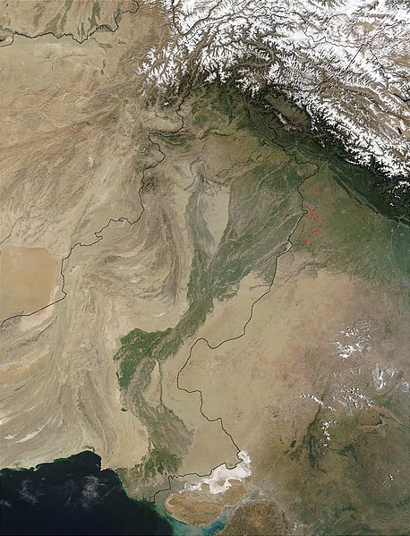
ファイル:Indus.A2002274.0610.1km.jpg

このプレビューのサイズ: 458 × 599 ピクセル。 その他の解像度: 183 × 240 ピクセル | 367 × 480 ピクセル | 587 × 768 ピクセル | 783 × 1,024 ピクセル | 1,300 × 1,700 ピクセル。
元のファイル (1,300 × 1,700 ピクセル、ファイルサイズ: 480キロバイト、MIME タイプ: image/jpeg)
ファイルの履歴
過去の版のファイルを表示するには、その版の日時をクリックしてください。
| 日付と時刻 | サムネイル | 寸法 | 利用者 | コメント | |
|---|---|---|---|---|---|
| 現在の版 | 2008年3月28日 (金) 13:03 |  | 1,300 × 1,700 (480キロバイト) | File Upload Bot (Magnus Manske) | {{BotMoveToCommons|en.wikipedia}} {{Information |Description={{en|en:Satellite image of the en:Indus River basin. Red dots indicate fires. International boundaries are superimposed; the boundary through en:Jammu and Kashmir reflects the [[ |
ファイルの使用状況
以下のページがこのファイルを使用しています:
グローバルなファイル使用状況
以下に挙げる他のウィキがこの画像を使っています:
- af.wikipedia.org での使用状況
- ar.wikipedia.org での使用状況
- arz.wikipedia.org での使用状況
- ast.wikipedia.org での使用状況
- as.wikipedia.org での使用状況
- azb.wikipedia.org での使用状況
- az.wikipedia.org での使用状況
- ba.wikipedia.org での使用状況
- be-tarask.wikipedia.org での使用状況
- bh.wikipedia.org での使用状況
- bn.wikipedia.org での使用状況
- bo.wikipedia.org での使用状況
- br.wikipedia.org での使用状況
- bxr.wikipedia.org での使用状況
- ca.wikipedia.org での使用状況
- ceb.wikipedia.org での使用状況
- ce.wikipedia.org での使用状況
- ckb.wikipedia.org での使用状況
- cy.wikipedia.org での使用状況
- da.wikipedia.org での使用状況
- en.wikipedia.org での使用状況
- eo.wikipedia.org での使用状況
- es.wikipedia.org での使用状況
- fa.wikipedia.org での使用状況
- fiu-vro.wikipedia.org での使用状況
- gd.wikipedia.org での使用状況
- gl.wikipedia.org での使用状況
- hi.wikipedia.org での使用状況
- hy.wikipedia.org での使用状況
- ia.wikipedia.org での使用状況
- id.wikipedia.org での使用状況
- ilo.wikipedia.org での使用状況
- incubator.wikimedia.org での使用状況
- is.wikipedia.org での使用状況
- it.wikipedia.org での使用状況
このファイルのグローバル使用状況を表示する。

