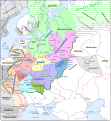
ファイル:Kievan Rus in 1237 (en).svg

この SVG ファイルのこの PNG プレビューのサイズ: 553 × 600 ピクセル. その他の解像度: 221 × 240 ピクセル | 442 × 480 ピクセル | 708 × 768 ピクセル | 944 × 1,024 ピクセル | 1,888 × 2,048 ピクセル | 1,204 × 1,306 ピクセル。
元のファイル (SVG ファイル、1,204 × 1,306 ピクセル、ファイルサイズ: 332キロバイト)
ファイルの履歴
過去の版のファイルを表示するには、その版の日時をクリックしてください。
| 日付と時刻 | サムネイル | 寸法 | 利用者 | コメント | |
|---|---|---|---|---|---|
| 現在の版 | 2021年9月25日 (土) 08:06 |  | 1,204 × 1,306 (332キロバイト) | Veverve | "Khvalisy" changed to to "Khvalis" |
| 2021年4月9日 (金) 19:16 |  | 1,204 × 1,306 (360キロバイト) | Veverve | "Principalty of Vladimir-Suzdal" corrected to "Principality of Vladimir-Suzdal" | |
| 2020年5月16日 (土) 17:04 |  | 1,204 × 1,306 (360キロバイト) | Goran tek-en | Named changed as requested by user:Veverve | |
| 2020年2月12日 (水) 17:39 |  | 1,204 × 1,306 (318キロバイト) | Goran tek-en | Changed name of Vladimir as requested bu Veverve | |
| 2020年2月12日 (水) 16:59 |  | 1,204 × 1,306 (317キロバイト) | Goran tek-en | {{Information |description ={{en|1=Map of the Kievan Rus in 1237. The nales of tribes and peoples are in brown, the names of countries outside the Kievan Rus are in black. The names of principalties of the Kievan Rus are in blue; if a principalty bears the a name which comes directly from the name of its capital (e.g. the Principalty of Kiev), the complete name of the paincipalty is not on the map and the capital name is in blue.}} |date =20200212 |source ={{Own}}<br>... |
ファイルの使用状況
以下の 4 ページがこのファイルを使用しています:
グローバルなファイル使用状況
以下に挙げる他のウィキがこの画像を使っています:
- be.wikipedia.org での使用状況
- bg.wikipedia.org での使用状況
- ca.wikipedia.org での使用状況
- cy.wikipedia.org での使用状況
- da.wikipedia.org での使用状況
- de.wikipedia.org での使用状況
- en.wikipedia.org での使用状況
- es.wikipedia.org での使用状況
- hy.wikipedia.org での使用状況
- it.wikipedia.org での使用状況
- ko.wikipedia.org での使用状況
- la.wikipedia.org での使用状況
- nl.wikipedia.org での使用状況
- nn.wikipedia.org での使用状況
- no.wikipedia.org での使用状況
- pt.wikipedia.org での使用状況
- ro.wikipedia.org での使用状況
- rue.wikipedia.org での使用状況
- sw.wikipedia.org での使用状況
- tt.wikipedia.org での使用状況
- uk.wikipedia.org での使用状況
- www.wikidata.org での使用状況

