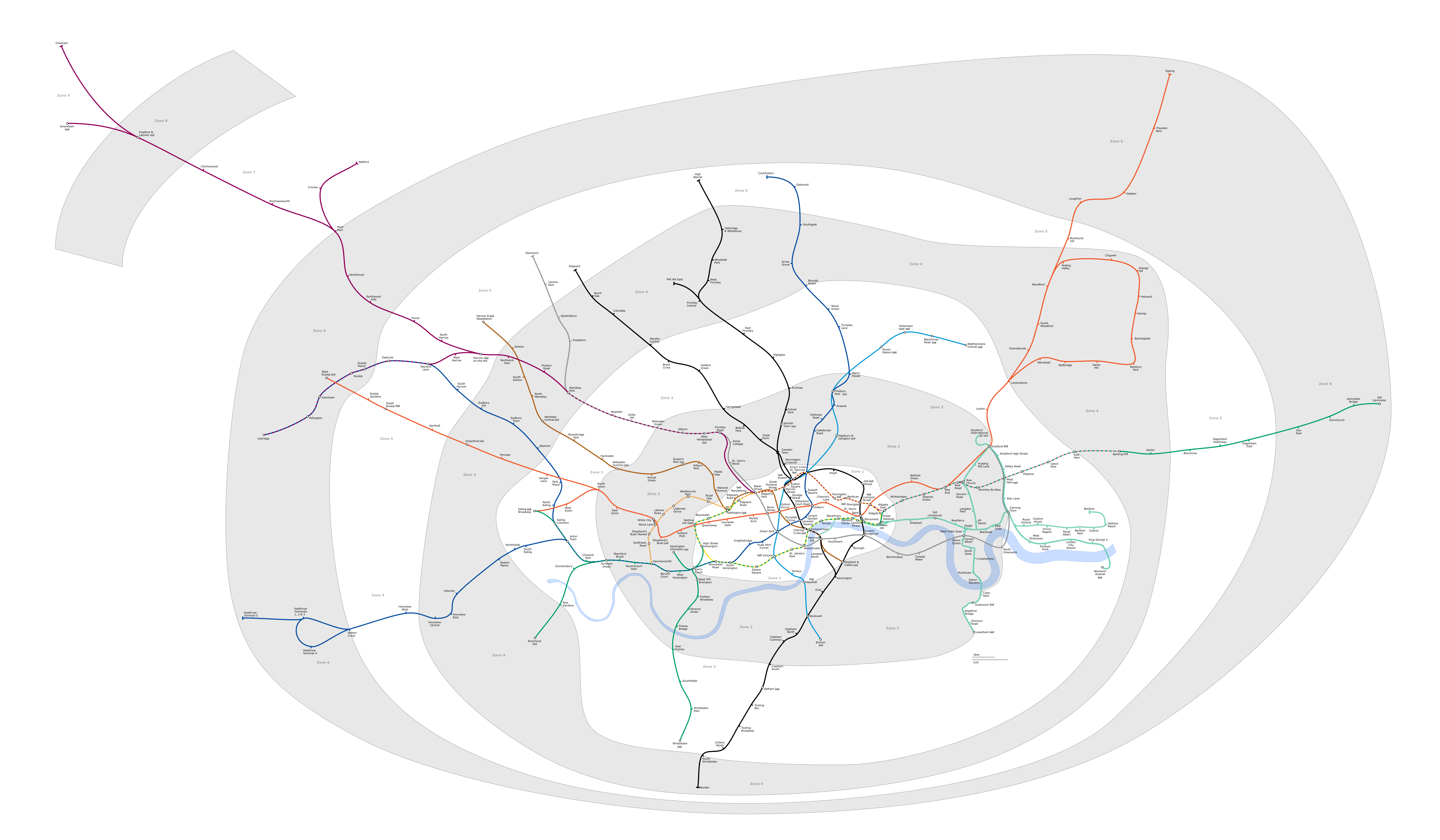
ファイル:London Underground full map.png
このプレビューのサイズ: 800 × 467 ピクセル。 その他の解像度: 320 × 187 ピクセル | 640 × 373 ピクセル | 1,024 × 597 ピクセル | 1,280 × 747 ピクセル | 2,560 × 1,493 ピクセル | 6,000 × 3,500 ピクセル。
元のファイル (6,000 × 3,500 ピクセル、ファイルサイズ: 1.36メガバイト、MIME タイプ: image/png)
ウィキメディア・コモンズのファイルページにある説明を、以下に表示します。
|
Generated as part of the London Underground geographic maps project by software written by ed g2s • talk and James D. Forrester utilising GPS data.
NB: Routes between stations are interpolated and may not be geographically accurate

|
この文書は、フリーソフトウェア財団発行のGNUフリー文書利用許諾書 (GNU Free Documentation License) 1.2またはそれ以降のバージョンの規約に基づき、複製や再配布、改変が許可されます。不可変更部分、表紙、背表紙はありません。このライセンスの複製は、GNUフリー文書利用許諾書という章に含まれています。 |
| このファイルはクリエイティブ・コモンズ 表示-継承 3.0 非移植ライセンスのもとに利用を許諾されています。 | ||
| ||
| このライセンスのテンプレートは、GFDLのライセンス・アップデートによりこのファイルに追加されたものです。 |
- あなたは以下の条件に従う場合に限り、自由に
- 共有 – 本作品を複製、頒布、展示、実演できます。
- 再構成 – 二次的著作物を作成できます。
- あなたの従うべき条件は以下の通りです。
- 表示 – あなたは適切なクレジットを表示し、ライセンスへのリンクを提供し、変更があったらその旨を示さなければなりません。これらは合理的であればどのような方法で行っても構いませんが、許諾者があなたやあなたの利用行為を支持していると示唆するような方法は除きます。
- 継承 – もしあなたがこの作品をリミックスしたり、改変したり、加工した場合には、あなたはあなたの貢献部分を元の作品とこれと同一または互換性があるライセンスの下に頒布しなければなりません。
Upload log
Latest versions of this file are uploaded from wts.wikivoyage-old.org.
元のファイルページはこちら。以下の利用者は全てwts.wikivoyage-oldに属します。
org:
- 2010-02-11 19:08:44 4100×2374 (1,076,793 bytes) (WT-shared) Peterfitzgerald attempted fix (Import from wikitravel.org/shared)
- 2009-12-20 21:41:21 4000×2312 (827,759 bytes) (WT-shared) Peterfitzgerald increase resolution (Import from wikitravel.org/shared)
- 2009-12-20 00:59:42 3000×1734 (571,486 bytes) (WT-shared) Peterfitzgerald == Summary == {{Imagecredit|credit=[[:wmc:User:DavidCane]], [[:wmc:User:Ed g2s]], Peter Fitzgerald|captureDate=19 December 2009|location=Lon (Import from wikitravel.org/shared)
ファイルの履歴
過去の版のファイルを表示するには、その版の日時をクリックしてください。
| 日付と時刻 | サムネイル | 寸法 | 利用者 | コメント | |
|---|---|---|---|---|---|
| 現在の版 | 2018年2月4日 (日) 23:23 | | 6,000 × 3,500 (1.36メガバイト) | DavidCane | Amend to correspond to svg version |
| 2015年10月8日 (木) 13:04 |  | 6,000 × 3,500 (1.1メガバイト) | RokerHRO | optipng -o7 -i0 -zc1-9 -zm1-9 -zs0-3 -f0-5 → 19.47% decrease | |
| 2014年8月12日 (火) 03:26 |  | 6,000 × 3,500 (1.36メガバイト) | Jc86035 | Updated again | |
| 2014年8月8日 (金) 12:07 |  | 6,000 × 3,500 (1.35メガバイト) | Jc86035 | again, updated from SVG version | |
| 2013年12月3日 (火) 15:15 |  | 6,000 × 3,500 (1.35メガバイト) | Jc86035 | Updated from SVG at File:London Underground full map.svg | |
| 2012年11月22日 (木) 08:42 |  | 4,000 × 2,320 (274キロバイト) | Atsirlin | Reverted to version as of 01:42, 6 January 2007: OK, importing new versions was a bad idea... | |
| 2012年11月22日 (木) 08:32 |  | 4,100 × 2,374 (1.03メガバイト) | OgreBot | (BOT): Uploading old version of file from wts.wikivoyage-old; originally uploaded on 2010-02-11 19:08:44 by (WT-shared) Peterfitzgerald | |
| 2012年11月22日 (木) 08:32 |  | 4,000 × 2,312 (808キロバイト) | OgreBot | (BOT): Uploading old version of file from wts.wikivoyage-old; originally uploaded on 2009-12-20 21:41:21 by (WT-shared) Peterfitzgerald | |
| 2012年11月22日 (木) 08:32 |  | 3,000 × 1,734 (558キロバイト) | OgreBot | (BOT): Uploading old version of file from wts.wikivoyage-old; originally uploaded on 2009-12-20 00:59:42 by (WT-shared) Peterfitzgerald | |
| 2007年1月6日 (土) 01:42 |  | 4,000 × 2,320 (274キロバイト) | Ed g2s | new zone 4 boundary |
ファイルの使用状況
以下のページがこのファイルを使用しています:
グローバルなファイル使用状況
以下に挙げる他のウィキがこの画像を使っています:
- da.wikipedia.org での使用状況
- en.wikipedia.org での使用状況
- en.wikivoyage.org での使用状況
- es.wikipedia.org での使用状況
- fr.wikivoyage.org での使用状況
- he.wikipedia.org での使用状況
- hi.wikipedia.org での使用状況
- hu.wikipedia.org での使用状況
- ko.wikipedia.org での使用状況
- nap.wikipedia.org での使用状況
- nl.wikipedia.org での使用状況
- Acton Town (metrostation)
- Alperton (metrostation)
- Amersham (metrostation)
- Arnos Grove (metrostation)
- Dagenham East (metrostation)
- Debden (metrostation)
- Dagenham Heathway (metrostation)
- Fairlop (metrostation)
- Finchley Central (metrostation)
- Ickenham (metrostation)
- Station Balham
- Barkingside (metrostation)
- Becontree (metrostation)
- Boston Manor (metrostation)
- Bounds Green (metrostation)
- Brent Cross (metrostation)
- Buckhurst Hill (metrostation)
- Burnt Oak (metrostation)
- Oakwood (metrostation)
- Osterley (metrostation)
- Stanmore (metrostation)
- Gants Hill (metrostation)
- Grange Hill (metrostation)
- Canons Park (metrostation)
- Station Chalfont & Latimer
- Chesham (metrostation)
- Chigwell (metrostation)
- Station Chorleywood
- Cockfosters (metrostation)
- Colindale (metrostation)
- Colliers Wood (metrostation)
- Croxley (metrostation)
- Custom House for ExCeL
- Cyprus (metrostation)
- Queensbury (metrostation)
このファイルのグローバル使用状況を表示する。