ファイル:Map of Warren County, Indiana.svg

この SVG ファイルのこの PNG プレビューのサイズ: 600 × 600 ピクセル. その他の解像度: 240 × 240 ピクセル | 480 × 480 ピクセル | 768 × 768 ピクセル | 1,024 × 1,024 ピクセル | 2,048 × 2,048 ピクセル。
元のファイル (SVG ファイル、768 × 768 ピクセル、ファイルサイズ: 583キロバイト)
ウィキメディア・コモンズのファイルページにある説明を、以下に表示します。
|
概要
| 解説 |
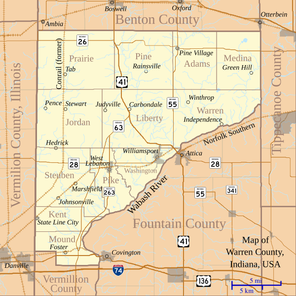
English: This is a map of Warren County, Indiana, USA which shows settlements, county and township borders, and major transportation routes. |
| 日付 | |
| 原典 | My own work, using custom-written MapScript applications with freely-available United States Census Bureau TIGER data |
| 作者 | Omnedon |
ライセンス
| この著作物の著作権者である私は、この著作物における権利を放棄しパブリックドメインとします。これは全世界で適用されます。 一部の国では、これが法的に可能ではない場合があります。その場合は、次のように宣言します。 私は、あらゆる人に対して、法により必要とされている条件を除き、如何なる条件も課すことなく、あらゆる目的のためにこの著作物を使用する権利を与えます。 |
ファイルの履歴
過去の版のファイルを表示するには、その版の日時をクリックしてください。
| 日付と時刻 | サムネイル | 寸法 | 利用者 | コメント | |
|---|---|---|---|---|---|
| 現在の版 | 2011年9月8日 (木) 04:15 | | 768 × 768 (583キロバイト) | Omnedon | == {{int:filedesc}} == {{Information |Description={{en|This is a map of Warren County, Indiana, USA which shows settlements, county and township borders, and major transportation routes.}} |Source=My own work, using custom-wr |
| 2011年2月13日 (日) 15:26 |  | 768 × 768 (731キロバイト) | Omnedon | == {{int:filedesc}} == {{Information |Description={{en|This is a map of Warren County, Indiana, USA which includes incorporated settlements, township borders and major transportation routes.}} |Source=My own work, using custo | |
| 2010年8月22日 (日) 15:45 |  | 768 × 768 (193キロバイト) | Omnedon | == {{int:filedesc}} == {{Information |Description={{en|This is a map of Warren County, Indiana, USA which shows settlements, townships, roads, railroads, and major rivers.}} |Source=My own work, using freely-available shape data and custom-written MapScri | |
| 2008年2月18日 (月) 04:45 |  | 768 × 768 (70キロバイト) | Omnedon | {{Information |Description={{en|This is a map of Warren County, Indiana, USA which shows settlements, townships, roads, railroads, and major rivers.}} |Source=My own work, using freely-available shape data and custom-written MapScript applications |Date=2 | |
| 2008年2月15日 (金) 22:17 |  | 768 × 768 (68キロバイト) | Omnedon | {{Information |Description={{en|This is a map of Warren County, Indiana, USA which shows settlements, townships, roads, railroads, and major rivers.}} |Source=My own work, using freely-available shape data and custom-written MapScript applications |Date=2 |
ファイルの使用状況
以下のページがこのファイルを使用しています:
グローバルなファイル使用状況
以下に挙げる他のウィキがこの画像を使っています:
- de.wikipedia.org での使用状況
- en.wikipedia.org での使用状況
- es.wikipedia.org での使用状況
- fr.wikipedia.org での使用状況