ファイル:Mediaeval universities.jpg
このプレビューのサイズ: 685 × 599 ピクセル。 その他の解像度: 274 × 240 ピクセル | 549 × 480 ピクセル | 878 × 768 ピクセル | 1,127 × 986 ピクセル。
元のファイル (1,127 × 986 ピクセル、ファイルサイズ: 1.17メガバイト、MIME タイプ: image/jpeg)
ウィキメディア・コモンズのファイルページにある説明を、以下に表示します。
|
概要
| 解説 |
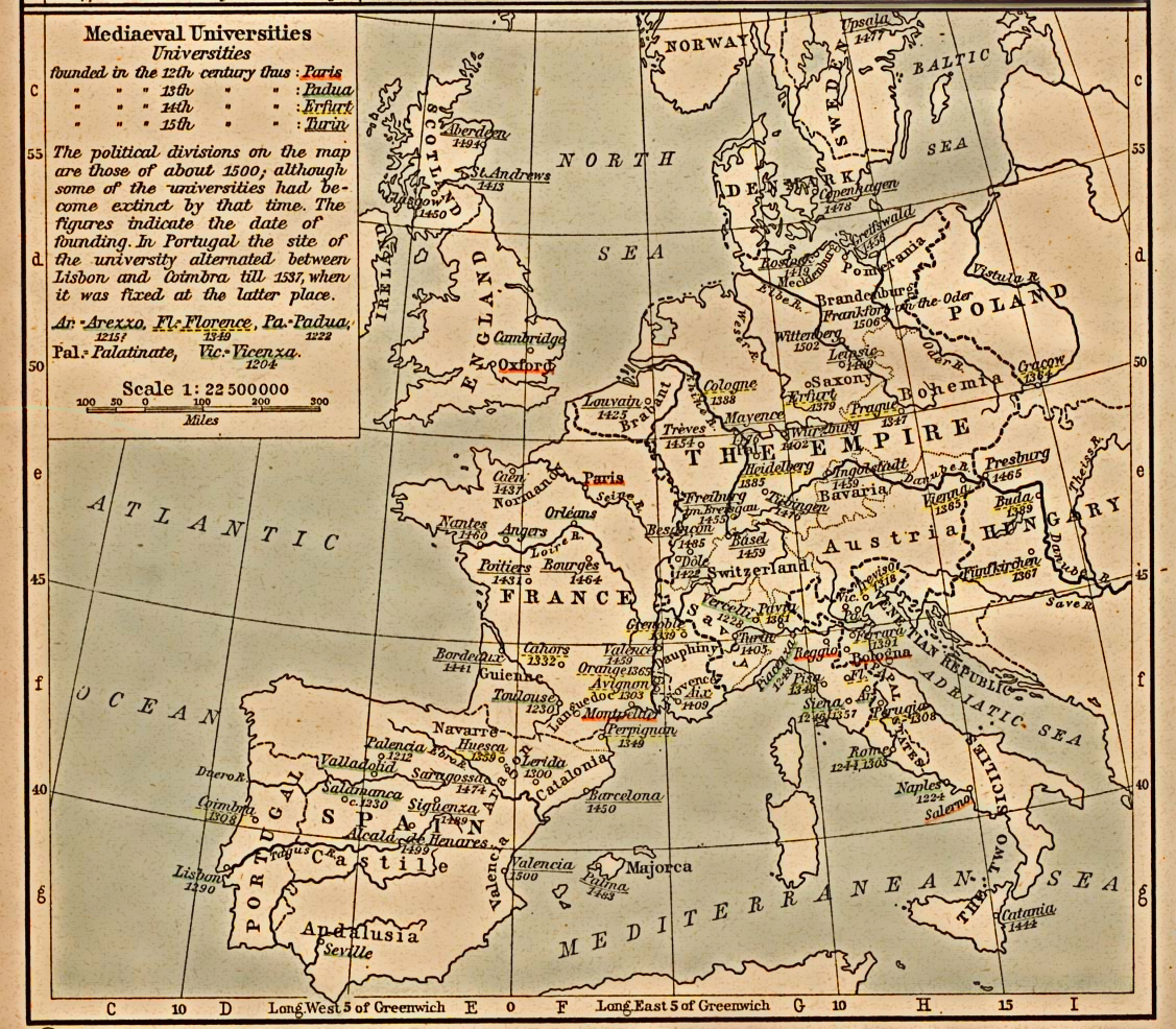
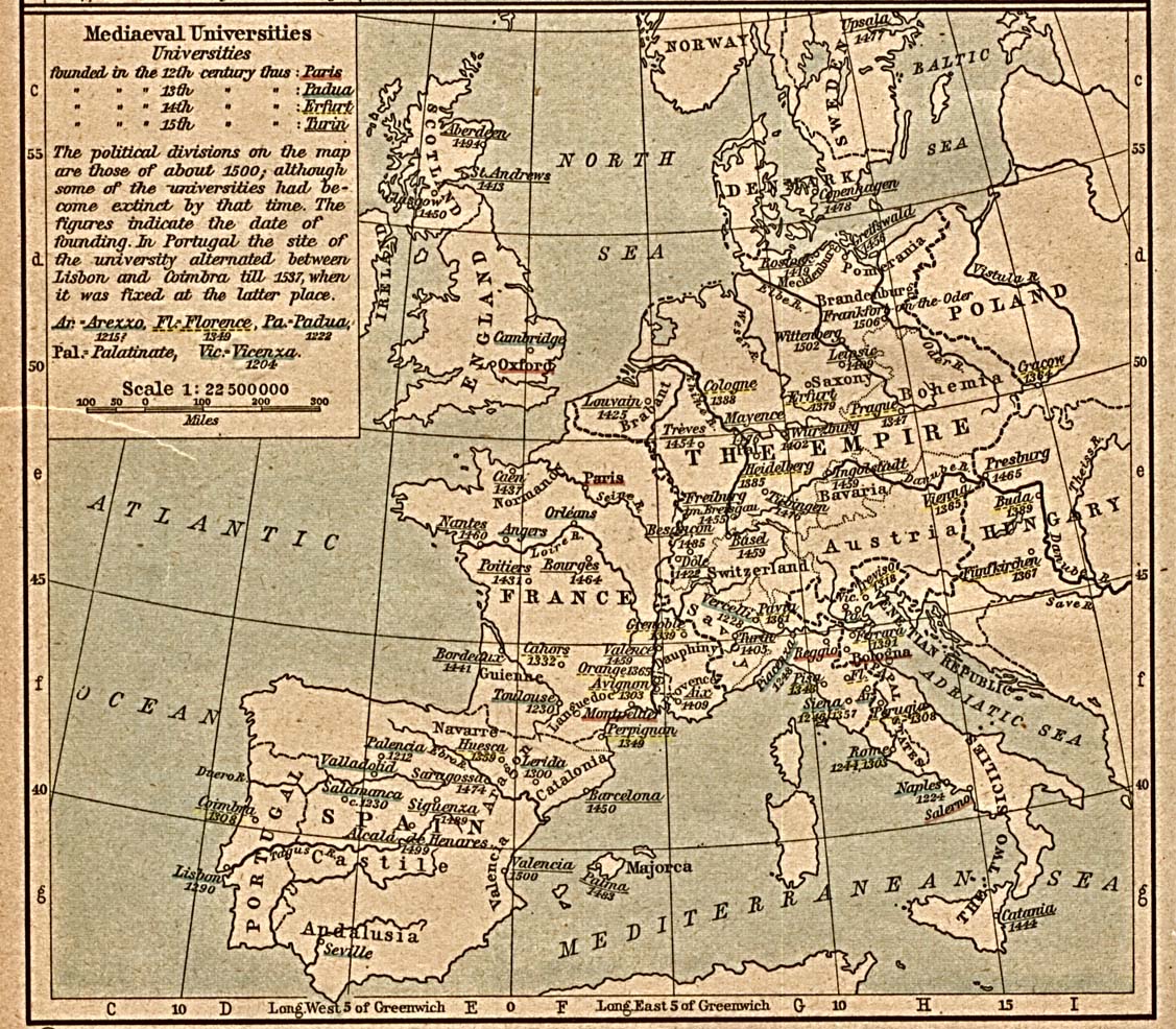
English: Scan from "Historical Atlas" by William R. Shepherd, New York, Henry Holt and Company, 1923. |
| 日付 | (the same map was included on a half-page in the 1911 edition) |
| 原典 | |
| 作者 | |
| 許可 (ファイルの再利用) |
From the FAQ @ http://www.lib.utexas.edu/maps/faq.html
|
| その他のバージョン | العربيَّة |
ライセンス
|
パブリックドメインの状態にある著作物をウィキメディア・コモンズに置くためには、アメリカ合衆国と著作物の本国の双方において著作権の保護期間が満了している必要があります。この著作物がアメリカ合衆国のものでない場合には、ファイルに対してその本国における著作権状況を示す著作権タグを付加する必要があります。
|
元のアップロードログ
en.wikipedia からコモンズに SreeBot によって移動されました。
元のファイルページはこちら。以下の利用者は全てen.wikipediaに属します。
Upload date | User | Bytes | Dimensions | Comment
- 2006-12-18 21:40 (UTC) | Jengod | 361656 (bytes) | 1127×986 | {{PD}} Scan from "Historical Atlas" by William R. Shepherd, New York, Henry Holt and Company, 1923. Original image at the [http://www.lib.utexas.edu/maps/ Perry-Castañeda Library Map Collection] at the [[University of Texas at Austin]] website: http:/
ファイルの履歴
過去の版のファイルを表示するには、その版の日時をクリックしてください。
| 日付と時刻 | サムネイル | 寸法 | 利用者 | コメント | |
|---|---|---|---|---|---|
| 現在の版 | 2012年7月30日 (月) 16:31 | | 1,127 × 986 (1.17メガバイト) | SteveMcCluskey | Improved legibility by reducing extraneous background detail, increasing contrast of image, and enhancing color saturation of underlining. |
| 2011年9月20日 (火) 18:38 |  | 1,127 × 986 (353キロバイト) | SreeBot | (Original text) : {{PD}} Scan from "Historical Atlas" by William R. Shepherd, New York, Henry Holt and Company, 1923. Original image at the [http://www.lib.utexas.edu/maps/ Perry-Castañeda Library Map Collection] at the [[University of Texas at Austin |
ファイルの使用状況
以下のページがこのファイルを使用しています:
グローバルなファイル使用状況
以下に挙げる他のウィキがこの画像を使っています:
- ast.wikipedia.org での使用状況
- azb.wikipedia.org での使用状況
- az.wikipedia.org での使用状況
- ca.wikipedia.org での使用状況
- cs.wikipedia.org での使用状況
- en.wikipedia.org での使用状況
- es.wikipedia.org での使用状況
- fr.wikipedia.org での使用状況
- id.wikipedia.org での使用状況
- ka.wikipedia.org での使用状況
- pt.wikipedia.org での使用状況
- sq.wikipedia.org での使用状況
- uk.wikipedia.org での使用状況
- uz.wikipedia.org での使用状況
- www.wikidata.org での使用状況