ファイル:Okterritory.png

このプレビューのサイズ: 800 × 477 ピクセル。 その他の解像度: 320 × 191 ピクセル | 640 × 382 ピクセル | 1,024 × 611 ピクセル | 1,280 × 763 ピクセル | 2,515 × 1,500 ピクセル。
元のファイル (2,515 × 1,500 ピクセル、ファイルサイズ: 534キロバイト、MIME タイプ: image/png)
ウィキメディア・コモンズのファイルページにある説明を、以下に表示します。
|

|
このlocator map画像は、ベクターイメージである SVG ファイルとして再作成されるべきです。これにはいくつかの利点があります。詳しくはCommons:Media for cleanupを参照してください。この画像の SVG 形式がすでに利用可能である場合は、アップロードしてください。アップロード後、この画像にあるこのテンプレートを{{Vector version available|新しい画像ファイル名.svg}}テンプレートで置き換えてください。
|
概要
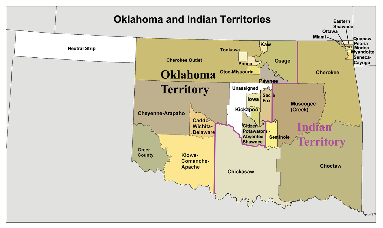
English: A map of the Oklahoma Territory and the reduced Indian Territory circa 1890's.
- In present day Oklahoma.
- Credits
- I made this using Census Bureau data and this 1892 map as a reference.
ライセンス
この作品の著作権者である私は、この作品を以下のライセンスで提供します。
このファイルはクリエイティブ・コモンズ 表示-継承 3.0 非移植ライセンスのもとに利用を許諾されています。
- あなたは以下の条件に従う場合に限り、自由に
- 共有 – 本作品を複製、頒布、展示、実演できます。
- 再構成 – 二次的著作物を作成できます。
- あなたの従うべき条件は以下の通りです。
- 表示 – あなたは適切なクレジットを表示し、ライセンスへのリンクを提供し、変更があったらその旨を示さなければなりません。これらは合理的であればどのような方法で行っても構いませんが、許諾者があなたやあなたの利用行為を支持していると示唆するような方法は除きます。
- 継承 – もしあなたがこの作品をリミックスしたり、改変したり、加工した場合には、あなたはあなたの貢献部分を元の作品とこれと同一または互換性があるライセンスの下に頒布しなければなりません。
ファイルの履歴
過去の版のファイルを表示するには、その版の日時をクリックしてください。
| 日付と時刻 | サムネイル | 寸法 | 利用者 | コメント | |
|---|---|---|---|---|---|
| 現在の版 | 2010年1月20日 (水) 16:34 | | 2,515 × 1,500 (534キロバイト) | Kmusser | spelling correction |
| 2010年1月20日 (水) 15:10 |  | 2,551 × 1,500 (557キロバイト) | Kmusser | increased resolution | |
| 2006年7月31日 (月) 18:02 |  | 600 × 358 (33キロバイト) | Kmusser | == Summary == This is a map of Oklahoma and Indian Territory circa 1890's that I made using and Census Bureau data and [http://hdl.loc.gov/loc.gmd/g4021e.ct000224 this |
ファイルの使用状況
グローバルなファイル使用状況
以下に挙げる他のウィキがこの画像を使っています:
- af.wikipedia.org での使用状況
- ar.wikipedia.org での使用状況
- arz.wikipedia.org での使用状況
- bcl.wikipedia.org での使用状況
- bn.wikipedia.org での使用状況
- ca.wikipedia.org での使用状況
- Osages
- Chickasaw (grup humà)
- Choctaws
- Wichita (poble)
- Tonkawes
- Caddos
- Comtat de Cimarron
- Comtat de Beaver (Oklahoma)
- Oklahoma Panhandle
- Cinc tribus civilitzades
- Apatxe kiowa
- Territori Indi
- Nació Chickasaw
- Plantilla:Territori Indi
- Nació Choctaw d'Oklahoma
- Districte Apukshunnubbee
- Districte Moshulatubbee
- Districte Pushmataha
- Nació Muscogee
- Estat de Sequoyah
- Nació Seminola d'Oklahoma
- Indian Intercourse Act
- Llei Orgànica d'Oklahoma
- chr.wikipedia.org での使用状況
- chy.wikipedia.org での使用状況
- cy.wikipedia.org での使用状況
- de.wikipedia.org での使用状況
このファイルのグローバル使用状況を表示する。