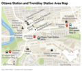
ファイル:Ottawa Station and Tremblay Station Area Map.png

元のファイル(1,140 × 1,002 ピクセル、ファイルサイズ: 693キロバイト、MIME タイプ: image/png)

概要

解説
English: Map of the area around Ottawa Station and Tremblay Station in Ottawa, Ontario, Canada
日付
原典 投稿者自身による著作物
作者 Ottawajin

ライセンス

This chart was created or started at Datawrapper.de. According to this section of their FAQ: "you have the full copyright to your charts and maps." That section also mentions Datawrapper's insistence on attribution. See this Datawrapper discussion on the Commons. See other free mapping and free charting sites. Since the chart author has a full copyright the chart author can choose any image license that also includes attribution. The Commons accepts several image licenses with attribution. For example; {{Cc-by-sa-4.0}}, {{Cc-by-4.0}}, and {{Attribution}}. The chart author has picked one below this paragraph. See other maps on Commons created with Datawrapper.de: Category:Datawrapper.de and this search for Datawrapper on the Commons. See other map resources.

Please add this template to the licensing section of Commons image pages for Datawrapper charts: {{Datawrapper.de}}

この作品の著作権者である私は、この作品を以下のライセンスで提供します。
w:ja:クリエイティブ・コモンズ
表示 継承
このファイルはクリエイティブ・コモンズ 表示-継承 4.0 国際ライセンスのもとに利用を許諾されています。
あなたは以下の条件に従う場合に限り、自由に
  • 共有 – 本作品を複製、頒布、展示、実演できます。
  • 再構成 – 二次的著作物を作成できます。
あなたの従うべき条件は以下の通りです。
  • 表示 – あなたは適切なクレジットを表示し、ライセンスへのリンクを提供し、変更があったらその旨を示さなければなりません。これらは合理的であればどのような方法で行っても構いませんが、許諾者があなたやあなたの利用行為を支持していると示唆するような方法は除きます。
  • 継承 – もしあなたがこの作品をリミックスしたり、改変したり、加工した場合には、あなたはあなたの貢献部分を元の作品とこれと同一または互換性があるライセンスの下に頒布しなければなりません。

キャプション

このファイルの内容を1行で記述してください
Map of the area around Ottawa Station and Tremblay Station in Ottawa, Ontario, Canada

このファイルに描写されている項目

題材

11 1 2021

ファイルの履歴

過去の版のファイルを表示するには、その版の日時をクリックしてください。

日付と時刻サムネイル寸法利用者コメント
現在の版2021年6月12日 (土) 02:362021年6月12日 (土) 02:36時点における版のサムネイル1,140 × 1,002 (693キロバイト)OttawajinCorrected 97 Airport Stop information, added Gee-Gees Field and Walmart Supercentre
2021年6月8日 (火) 08:402021年6月8日 (火) 08:40時点における版のサムネイル1,140 × 1,002 (672キロバイト)OttawajinCleaned up labels and added colour to better distinguish land usage patterns
2021年6月3日 (木) 11:072021年6月3日 (木) 11:07時点における版のサムネイル1,140 × 1,002 (591キロバイト)OttawajinUpdated with new Megabus stop information following closure of Ottawa Central Station Bus Terminal on June 1, 2021 added 97 airport connection information.
2021年1月11日 (月) 10:172021年1月11日 (月) 10:17時点における版のサムネイル1,140 × 1,002 (485キロバイト)OttawajinUploaded own work with UploadWizard

以下のページがこのファイルを使用しています:

グローバルなファイル使用状況

以下に挙げる他のウィキがこの画像を使っています:

メタデータ