ファイル:Ottoman Empire Administrative Divisions.png
このプレビューのサイズ: 552 × 600 ピクセル。 その他の解像度: 221 × 240 ピクセル | 442 × 480 ピクセル | 707 × 768 ピクセル | 943 × 1,024 ピクセル | 1,885 × 2,048 ピクセル | 4,455 × 4,840 ピクセル。
元のファイル (4,455 × 4,840 ピクセル、ファイルサイズ: 2.1メガバイト、MIME タイプ: image/png)
ウィキメディア・コモンズのファイルページにある説明を、以下に表示します。
|
概要
| 解説 |
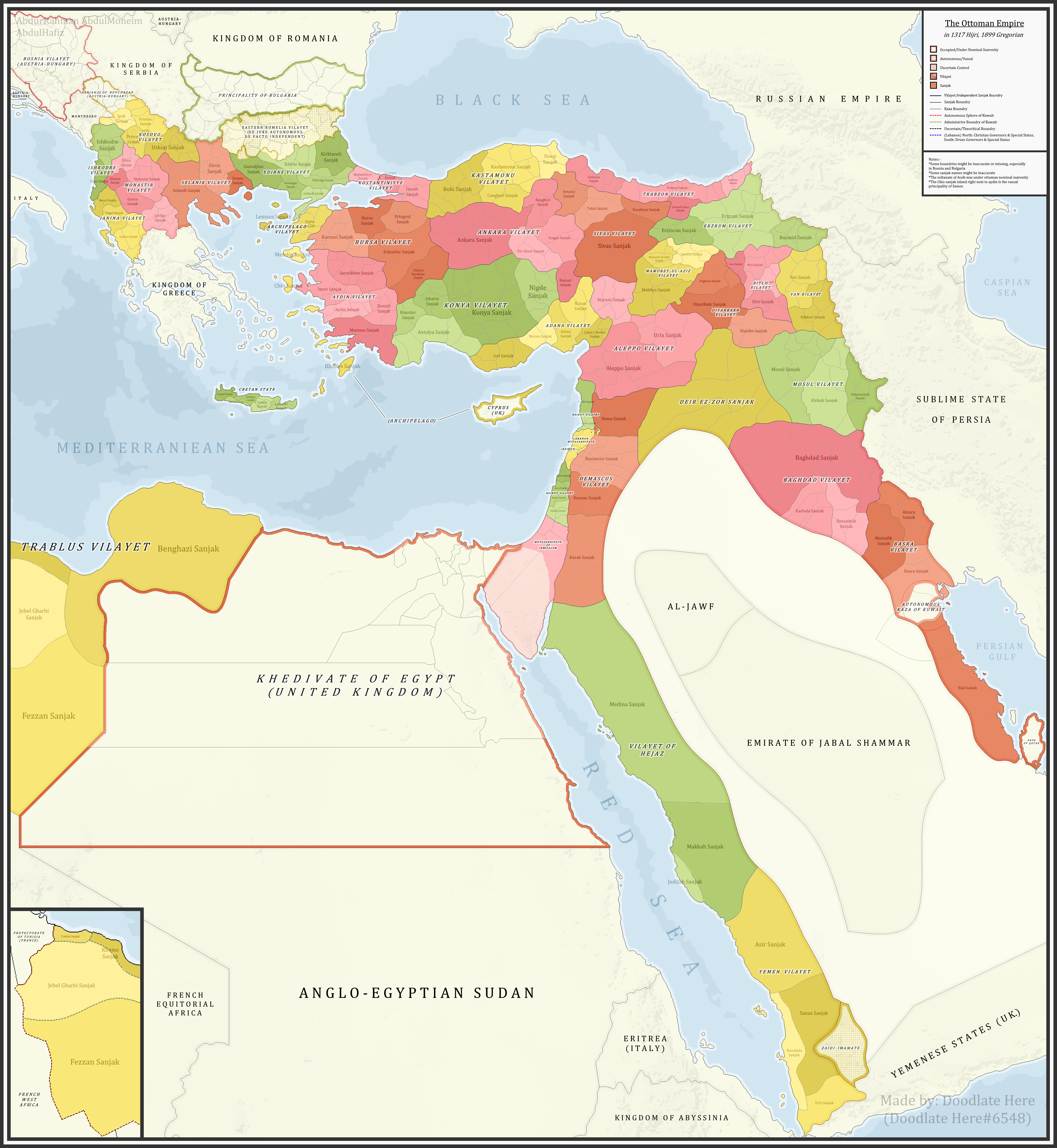
English: A detailed map showing the Ottoman Empire and its dependencies, including its administrative divisions, in 1899 CE (1317 Hijri). |
| 日付 | |
| 原典 |
投稿者自身による著作物 References:The sources that back up the maps are as follows: [1] Pavet de Courteille, Abel (1876). État présent de l'empire ottoman (in French). J. Dumaine. pp. 91–96. (for Yemen) [2] http://tarihvemedeniyet.org/2009/10/trablus-garb-vilayeti.html for Tripolitania [3] http://tarihvemedeniyet.org/2009/10/bosna-vilayeti.html for Bosnia [4] https://www.nsi.bg/nrnm/index.php?i=1&ezik=en for eastern Rumelia [5] http://hdl.loc.gov/loc.gmd/g7431f.ct002181 (Rest of Ottoman subdivisions, taken from the United States Library of Congress's Geography & Map Division, digital ID g7431f.ct002181) |
| 作者 | AbdurRahman AbdulMoneim |
ライセンス
この作品の著作権者である私は、この作品を以下のライセンスで提供します。
このファイルはクリエイティブ・コモンズ 表示-継承 4.0 国際ライセンスのもとに利用を許諾されています。
- あなたは以下の条件に従う場合に限り、自由に
- 共有 – 本作品を複製、頒布、展示、実演できます。
- 再構成 – 二次的著作物を作成できます。
- あなたの従うべき条件は以下の通りです。
- 表示 – あなたは適切なクレジットを表示し、ライセンスへのリンクを提供し、変更があったらその旨を示さなければなりません。これらは合理的であればどのような方法で行っても構いませんが、許諾者があなたやあなたの利用行為を支持していると示唆するような方法は除きます。
- 継承 – もしあなたがこの作品をリミックスしたり、改変したり、加工した場合には、あなたはあなたの貢献部分を元の作品とこれと同一または互換性があるライセンスの下に頒布しなければなりません。
| 注釈 | この画像には注釈がついています: コモンズで注釈を見る |
ファイルの履歴
過去の版のファイルを表示するには、その版の日時をクリックしてください。
| 日付と時刻 | サムネイル | 寸法 | 利用者 | コメント | |
|---|---|---|---|---|---|
| 現在の版 | 2021年11月16日 (火) 07:16 | | 4,455 × 4,840 (2.1メガバイト) | BasilLeaf | updates |
| 2021年5月5日 (水) 19:22 |  | 4,455 × 4,840 (2.11メガバイト) | Super Dromaeosaurus | Romanian Black Sea Snake Island, Romanian-Russian border at Dobruja-Bessarabia, removed lands in Banat that didn't belong to Romania then | |
| 2021年4月14日 (水) 18:17 |  | 4,455 × 4,840 (2.03メガバイト) | محمد٢ | Reverted to version as of 18:40, 19 January 2021 (UTC) | |
| 2021年2月8日 (月) 02:05 |  | 4,455 × 4,840 (2.1メガバイト) | BasilLeaf | Minor name fixes. Iran's official English name was "Sublime State of Persia". "Arab Gulf" Doesn't exist. There's "Arabian Gulf", a name that only came to decently widespread usage from 1960s. Contemporary internationally accepted term is "Persian Gulf". | |
| 2021年1月19日 (火) 18:40 |  | 4,455 × 4,840 (2.03メガバイト) | Userd898 | minor edit regarding the recoloring of a wrongly colored spot in haasa | |
| 2021年1月19日 (火) 18:05 |  | 4,455 × 4,840 (2.03メガバイト) | Userd898 | fixed some mistakes in yemen and labeled qatar as occupied source: https://www.euratlas.net/history/hisatlas/arabia/1904__AR.html | |
| 2021年1月14日 (木) 18:48 |  | 4,455 × 4,840 (2.1メガバイト) | BasilLeaf | Minor name fixes. Iran's official English name was "Sublime State of Persia". "Arab Gulf" Doesn't exist. There's "Arabian Gulf", a name that only came to decently widespread usage in 1960s. | |
| 2020年12月27日 (日) 19:15 |  | 4,455 × 4,840 (2.03メガバイト) | Userd898 | Uploaded own work with UploadWizard |
ファイルの使用状況
以下のページがこのファイルを使用しています:
グローバルなファイル使用状況
以下に挙げる他のウィキがこの画像を使っています:
- bg.wikipedia.org での使用状況
- bn.wikipedia.org での使用状況
- ca.wikipedia.org での使用状況
- ckb.wikipedia.org での使用状況
- de.wikipedia.org での使用状況
- el.wikipedia.org での使用状況
- en.wikipedia.org での使用状況
- Ottoman Empire
- Sanjak
- Administrative divisions of the Ottoman Empire
- Kosovo vilayet
- Baghdad vilayet
- Mosul vilayet
- Scutari vilayet
- Basra vilayet
- Ottoman Tripolitania
- Ottoman Syria
- Abdul Hamid II
- Ottoman Iraq
- Mount Lebanon Mutasarrifate
- Janina vilayet
- Beirut vilayet
- Syria vilayet
- Hejaz vilayet
- Talk:Greater Palestine
- User:Falcaorib
- es.wikipedia.org での使用状況
- fa.wikipedia.org での使用状況
- fi.wikipedia.org での使用状況
- fr.wikipedia.org での使用状況
- gl.wikipedia.org での使用状況
- he.wikipedia.org での使用状況
- it.wikipedia.org での使用状況
このファイルのグローバル使用状況を表示する。