ファイル:Paris-cite-haussmann.jpg
高解像度版はありません。
Paris-cite-haussmann.jpg (602 × 402 ピクセル、ファイルサイズ: 99キロバイト、MIME タイプ: image/jpeg)
ウィキメディア・コモンズのファイルページにある説明を、以下に表示します。
|
概要
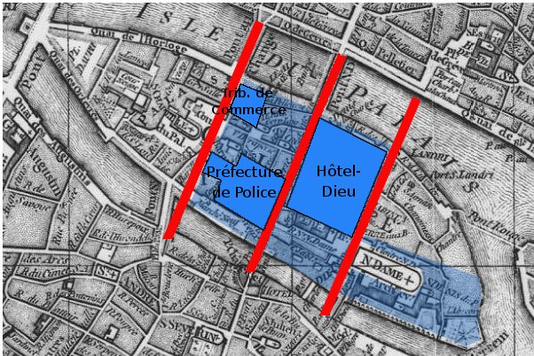
Paris, Ile de la Cité. A map based on the 1771 Robert de Vaugondy plan (cf File:Paris-cite-vaugondy-1771.jpg) and shows in dark blue the buildings, in light blue the public spaces and in red the streets created by Haussmann.
Derivated on a Gallica pic.
| Previous public domain rationale, no longer applicable | ||
|---|---|---|
|
ファイルの履歴
過去の版のファイルを表示するには、その版の日時をクリックしてください。
| 日付と時刻 | サムネイル | 寸法 | 利用者 | コメント | |
|---|---|---|---|---|---|
| 現在の版 | 2006年2月16日 (木) 22:05 | | 602 × 402 (99キロバイト) | Thbz | Paris, Ile de la Cité. A map based on the 1771 Vaugondy plan (cf Image:Paris-cite-vaugondy-1771.jpg) and shows in dark blue the buildings, in light blue the public spaces and in red the streets created by Haussmann. Derivated on a Gallica pic. {{G |
ファイルの使用状況
以下のページがこのファイルを使用しています:
グローバルなファイル使用状況
以下に挙げる他のウィキがこの画像を使っています:
- ca.wikipedia.org での使用状況
- cs.wikipedia.org での使用状況
- en.wikipedia.org での使用状況
- fi.wikipedia.org での使用状況
- fr.wikipedia.org での使用状況
- he.wikipedia.org での使用状況
- it.wikipedia.org での使用状況
- ru.wikipedia.org での使用状況
- uk.wikipedia.org での使用状況