ファイル:Rhein-Herne-Kanal bei Oberhausen.jpg

このプレビューのサイズ: 800 × 600 ピクセル。 その他の解像度: 320 × 240 ピクセル | 640 × 480 ピクセル | 1,024 × 768 ピクセル | 1,280 × 960 ピクセル | 2,560 × 1,920 ピクセル。
元のファイル (2,560 × 1,920 ピクセル、ファイルサイズ: 1.15メガバイト、MIME タイプ: image/jpeg)
ウィキメディア・コモンズのファイルページにある説明を、以下に表示します。
|
概要
| 解説 |
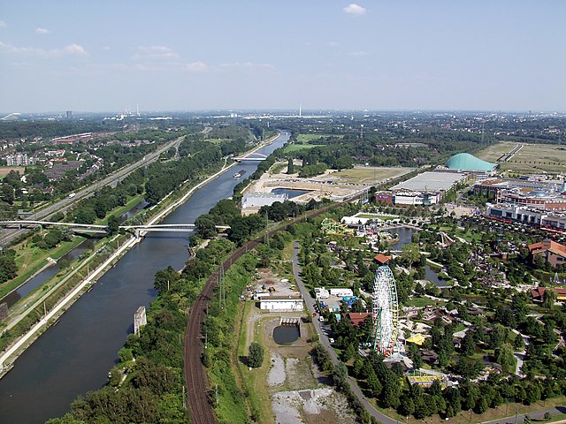
Deutsch: Der Rhein-Herne-Kanal bei Oberhausen. Aufnahmestandpunkt: Dach des Gasomoters Oberhausen
|
||||||||||||||||||||
| 日付 | |||||||||||||||||||||
| 原典 | 投稿者自身による著作物 | ||||||||||||||||||||
| 作者 |
|
||||||||||||||||||||
| 帰属 (ライセンスによる要求事項) | © Raimond Spekking / | ||||||||||||||||||||

| カメラの位置 | | 以下のサービスでこの位置を確認する: オープンストリートマップ |
|---|
ライセンス
I have published this image as author under the Creative-Commons-Licence CC BY-SA 4.0.. This means that free online usage outside of Wikimedia projects under the following terms of licence is possible:
- The image is credited with "© Raimond Spekking / CC BY-SA 4.0 (via Wikimedia Commons)"
For all other kind of usages (books, journales, flyers, etc.) click on the following button. You will get all information needed.
I would be happy to receive a specimen copy or the URL of the website where the image is used.
Please write an email to raimond.spekking@gmail.com (GPG encrypted emails are welcome: Key-ID: 0xB12BE7A6), if you
- need the image in a higher resolution
- need my postal address for sending a specimen copy
- have further questions to the terms of licence
この作品の著作権者である私は、この作品を以下のライセンスで提供します。
このファイルはクリエイティブ・コモンズ 表示-継承 4.0 国際ライセンスのもとに利用を許諾されています。
帰属: © Raimond Spekking / CC BY-SA 4.0 (via Wikimedia Commons)
- あなたは以下の条件に従う場合に限り、自由に
- 共有 – 本作品を複製、頒布、展示、実演できます。
- 再構成 – 二次的著作物を作成できます。
- あなたの従うべき条件は以下の通りです。
- 表示 – あなたは適切なクレジットを表示し、ライセンスへのリンクを提供し、変更があったらその旨を示さなければなりません。これらは合理的であればどのような方法で行っても構いませんが、許諾者があなたやあなたの利用行為を支持していると示唆するような方法は除きます。
- 継承 – もしあなたがこの作品をリミックスしたり、改変したり、加工した場合には、あなたはあなたの貢献部分を元の作品とこれと同一または互換性があるライセンスの下に頒布しなければなりません。
ファイルの履歴
過去の版のファイルを表示するには、その版の日時をクリックしてください。
| 日付と時刻 | サムネイル | 寸法 | 利用者 | コメント | |
|---|---|---|---|---|---|
| 現在の版 | 2011年5月4日 (水) 19:09 | | 2,560 × 1,920 (1.15メガバイト) | Raymond | image in full resolution |
| 2005年6月1日 (水) 19:56 |  | 1,024 × 768 (177キロバイト) | Raymond | {{Information| |Description = Rhein-Herne-Kanal at Oberhausen, Germany |Source = own photography |Date = 8. Aug. 2004 |Author = ~~~ - Raimond Spekking |Permission = |other_versions = }} {{GFDL-self}} |
ファイルの使用状況
以下のページがこのファイルを使用しています:
グローバルなファイル使用状況
以下に挙げる他のウィキがこの画像を使っています:
- an.wikipedia.org での使用状況
- arz.wikipedia.org での使用状況
- azb.wikipedia.org での使用状況
- bg.wikipedia.org での使用状況
- ceb.wikipedia.org での使用状況
- de.wikipedia.org での使用状況
- 14. Juli
- Ruhrgebiet
- Oberhausen
- Rhein-Herne-Kanal
- Gasometer Oberhausen
- Kanalschwimmen
- Emscherland
- Portal:Ruhrgebiet
- Portal:Ruhrgebiet/Galerie
- Diskussion:Rhein-Herne-Kanal
- Benutzer:AlterVista/Galerie
- Benutzer:Raymond/OBE
- Portal:Ruhrgebiet/Topartikel/Archiv/2007
- Verkehr in Nordrhein-Westfalen
- Benutzer:NatiSythen/RIKArbeit/Kbild
- Wikipedia:Kandidaten für exzellente Bilder/Archiv2013/5
- Stadtlandschaft (Geographie)
- de.wikivoyage.org での使用状況
- en.wikipedia.org での使用状況
- eo.wikipedia.org での使用状況
- fi.wikipedia.org での使用状況
- fr.wikipedia.org での使用状況
- is.wikipedia.org での使用状況
- li.wikipedia.org での使用状況
- pl.wikipedia.org での使用状況
- ru.wikipedia.org での使用状況
- sk.wikipedia.org での使用状況
- sv.wikipedia.org での使用状況
- th.wikipedia.org での使用状況
- uk.wikipedia.org での使用状況
- www.wikidata.org での使用状況