ファイル:River Forth course 3.png

このプレビューのサイズ: 800 × 322 ピクセル。 その他の解像度: 320 × 129 ピクセル | 640 × 258 ピクセル | 1,024 × 413 ピクセル | 2,000 × 806 ピクセル。
元のファイル (2,000 × 806 ピクセル、ファイルサイズ: 981キロバイト、MIME タイプ: image/png)
ウィキメディア・コモンズのファイルページにある説明を、以下に表示します。
|
概要
| 解説 |
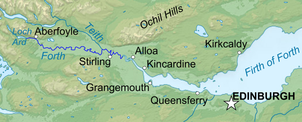
English: Topographic map in English of Scotland This is a lighter raster JPG format version of Image:Scotland_topographic_map-en.svg which should be used in the article pages, the vector graphics version purpose being for modification and / or translation. Français : Carte topographique en anglais de l'Écosse. *UTM projection ; WGS84 datum ; shaded relief (composite image of N-W, W and N lightning positions) ;Ceci est une version bitmap au format JPG et de poids de fichier plus léger de Image:Scotland_topographic_map-fr.svg qui devrait être utilisée dans les pages d'articles, la version vectorisée SVG étant destinée à faciliter les modifications et / ou traductions. *Scales: **Topography and shore/lakes limits: 1:872,000 (accuracy: 218 m) until 60.38° and 1:3,800,000 (accuracy: 950 m) North of 60.38° ; ** Bathymetry: 1:7,588,000 (accuracy: 1,897 m) |
| 日付 | (UTC) |
| 原典 |
このファイルの派生元: Scotland topographic map-en.jpg:  |
| 作者 |
|
この画像には画像編集が施されています。原本に対して次のデジタル的な変更が行われました。
|
ライセンス
この作品の著作権者である私は、この作品を以下のライセンスで提供します。
- あなたは以下の条件に従う場合に限り、自由に
- 共有 – 本作品を複製、頒布、展示、実演できます。
- 再構成 – 二次的著作物を作成できます。
- あなたの従うべき条件は以下の通りです。
- 表示 – あなたは適切なクレジットを表示し、ライセンスへのリンクを提供し、変更があったらその旨を示さなければなりません。これらは合理的であればどのような方法で行っても構いませんが、許諾者があなたやあなたの利用行為を支持していると示唆するような方法は除きます。
- 継承 – もしあなたがこの作品をリミックスしたり、改変したり、加工した場合には、あなたはあなたの貢献部分を元の作品とこれと同一または互換性があるライセンスの下に頒布しなければなりません。

|
この文書は、フリーソフトウェア財団発行のGNUフリー文書利用許諾書 (GNU Free Documentation License) 1.2またはそれ以降のバージョンの規約に基づき、複製や再配布、改変が許可されます。不可変更部分、表紙、背表紙はありません。このライセンスの複製は、GNUフリー文書利用許諾書という章に含まれています。 |
あなたは上記のライセンスから、どれか一つ以上を選択できます。
元のアップロードログ
This image is a derivative work of the following images:
- File:Scotland_topographic_map-en.jpg licensed with Cc-by-sa-3.0,2.5,2.0,1.0, GFDL
- 2010-07-17T21:41:29Z Sting 2400x3450 (2398211 Bytes) Color profile
- 2008-09-24T23:35:01Z Sting 2400x3450 (2082807 Bytes) Completely new background : raster topography and using ETOPO1 data for bathymetry ; new standard colors
- 2007-12-14T01:02:41Z Sting 2400x3450 (2224139 Bytes) Additional name
- 2007-12-12T20:55:32Z Sting 2400x3450 (2220337 Bytes) Correction in key
- 2007-12-12T16:18:25Z Sting 2400x3450 (2218854 Bytes) {{Location|57|00|00|N|04|00|00|W|scale:4000000}} {{Information |Description=Topographic map in English of [[:en:Scotland|Scotland]]This is a lighter raster JPG format version of [[:Image:Scotland_topographic_map-en.svg]] whi
Uploaded with derivativeFX
ファイルの履歴
過去の版のファイルを表示するには、その版の日時をクリックしてください。
| 日付と時刻 | サムネイル | 寸法 | 利用者 | コメント | |
|---|---|---|---|---|---|
| 現在の版 | 2013年1月22日 (火) 22:04 | 2,000 × 806 (981キロバイト) | VanguardScot | Added loch ard, highlighted the actual river forth | |
| 2013年1月22日 (火) 21:57 | 2,988 × 1,204 (991キロバイト) | VanguardScot | added grangemouth | ||
| 2013年1月17日 (木) 22:27 | 715 × 263 (314キロバイト) | VanguardScot | == {{int:filedesc}} == {{Information |Description={{en|Topographic map in English of Scotland<br/>This is a lighter raster JPG format version of Image:Scotland_topographic_map-en.svg which should be used in the article pages, the ... |
ファイルの使用状況
以下のページがこのファイルを使用しています:
グローバルなファイル使用状況
以下に挙げる他のウィキがこの画像を使っています:
- ca.wikipedia.org での使用状況
- cs.wikipedia.org での使用状況
- en.wikipedia.org での使用状況
- et.wikipedia.org での使用状況
- fa.wikipedia.org での使用状況
- fi.wikipedia.org での使用状況
- fr.wikipedia.org での使用状況
- he.wikipedia.org での使用状況
- is.wikipedia.org での使用状況
- it.wikipedia.org での使用状況
- no.wikipedia.org での使用状況
- sh.wikipedia.org での使用状況
- sr.wikipedia.org での使用状況
- uk.wikipedia.org での使用状況