ファイル:Special member state territories and the European Union.svg

この SVG ファイルのこの PNG プレビューのサイズ: 512 × 258 ピクセル. その他の解像度: 320 × 161 ピクセル | 640 × 323 ピクセル | 1,024 × 516 ピクセル | 1,280 × 645 ピクセル | 2,560 × 1,290 ピクセル。
元のファイル (SVG ファイル、512 × 258 ピクセル、ファイルサイズ: 835キロバイト)
ウィキメディア・コモンズのファイルページにある説明を、以下に表示します。
|
概要
| 解説 |
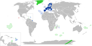
English:
European Union
Outermost regions
Overseas countries and territories
Special cases
Other special territories Français : Union européenne
Régions ultrapériphériques
Pays et territoires d'outre-mer
Cas spéciaux
Autres territoires spéciaux |
| 日付 | |
| 原典 | 投稿者自身による著作物 |
| 作者 | Glentamara |
| SVG 開発 |
ライセンス
| この著作物の著作権者である私は、この著作物における権利を放棄しパブリックドメインとします。これは全世界で適用されます。 一部の国では、これが法的に可能ではない場合があります。その場合は、次のように宣言します。 私は、あらゆる人に対して、法により必要とされている条件を除き、如何なる条件も課すことなく、あらゆる目的のためにこの著作物を使用する権利を与えます。 |
ファイルの履歴
過去の版のファイルを表示するには、その版の日時をクリックしてください。
| 日付と時刻 | サムネイル | 寸法 | 利用者 | コメント | |
|---|---|---|---|---|---|
| 現在の版 | 2022年6月8日 (水) 19:12 | | 512 × 258 (835キロバイト) | Nablicus | new version |
| 2020年7月17日 (金) 10:13 |  | 512 × 259 (736キロバイト) | Alcaios | fixed – those were models I use to check the scale | |
| 2020年7月16日 (木) 23:03 |  | 512 × 258 (672キロバイト) | Nablicus | Reverted to version as of 19:08, 16 July 2020 (UTC). There is an extra UK and Iceland in the middle of Canada... | |
| 2020年7月16日 (木) 19:53 |  | 512 × 259 (753キロバイト) | Alcaios | frame | |
| 2020年7月16日 (木) 19:50 |  | 512 × 258 (681キロバイト) | Alcaios | minor fixed on Greenland mar. zone | |
| 2020年7月16日 (木) 19:46 |  | 512 × 258 (681キロバイト) | Alcaios | Added maritime zone of Gree,land based on https://www.marineregions.org/eezdetails.php?mrgid=8438 | |
| 2020年7月16日 (木) 19:32 |  | 512 × 259 (752キロバイト) | Alcaios | added Faroe Islands' maritime zone | |
| 2020年7月16日 (木) 19:08 |  | 512 × 258 (672キロバイト) | Alcaios | Maritime zones in the eastern Caribbean at the right scale, with the help of https://commons.wikimedia.org/wiki/File:Caribbean_maritime_boundaries_map.svg | |
| 2020年7月16日 (木) 18:44 |  | 512 × 259 (742キロバイト) | Alcaios | slight realignments | |
| 2020年7月16日 (木) 18:38 |  | 512 × 259 (742キロバイト) | Alcaios | typo in previous edit, read: "Northern Cyprus is not a special member state territory since..." –– the Åland archipelago is larger and almost reaches the Finnish coast |
ファイルの使用状況
以下のページがこのファイルを使用しています:
グローバルなファイル使用状況
以下に挙げる他のウィキがこの画像を使っています:
- ar.wikipedia.org での使用状況
- br.wikipedia.org での使用状況
- cs.wikipedia.org での使用状況
- de.wikipedia.org での使用状況
- en.wikipedia.org での使用状況
- European Union
- Neocolonialism
- Outline of the European Union
- Special territories of members of the European Economic Area
- Potential enlargement of the European Union
- External border of the European Union
- User:Falcaorib
- User:Xicomaia/sandbox
- User:Spinykitsune65/sandbox2
- User:A diehard editor/sandbox/EU infobox
- fa.wikipedia.org での使用状況
- fr.wikipedia.org での使用状況
- Aruba
- Ceuta
- Polynésie française
- Groenland
- Açores
- Saint-Pierre-et-Miquelon
- Îles Canaries
- Madère
- Îles Kerguelen
- Île Clipperton
- Îles Féroé
- Région ultrapériphérique
- Îles Éparses de l'océan Indien
- Curaçao
- Åland
- Melilla
- Archipel Crozet
- Terre Adélie
- Bonaire
- Saba
- Saint-Eustache (Antilles)
- Peñón de Vélez de la Gomera
- Peñón de Alhucemas
- Îles Saint-Paul et Amsterdam
- Plazas de soberanía
- Nouvelle-Calédonie
- Saint-Martin (royaume des Pays-Bas)
- Saint-Martin (Antilles françaises)
- Pays et territoire d'outre-mer
- Saint-Barthélemy (Antilles françaises)
- Union européenne
- États membres de l'Union européenne
- Terres australes et antarctiques françaises
このファイルのグローバル使用状況を表示する。