ファイル:Typhoon Halong 14 july 2002 0155Z.jpg

このプレビューのサイズ: 458 × 599 ピクセル。 その他の解像度: 183 × 240 ピクセル | 367 × 480 ピクセル | 587 × 768 ピクセル | 783 × 1,024 ピクセル | 1,566 × 2,048 ピクセル | 5,200 × 6,800 ピクセル。
元のファイル (5,200 × 6,800 ピクセル、ファイルサイズ: 4.36メガバイト、MIME タイプ: image/jpeg)
ウィキメディア・コモンズのファイルページにある説明を、以下に表示します。
|
概要
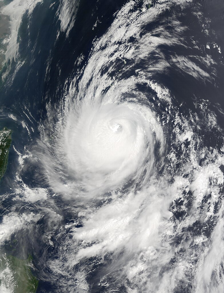
| 解説 | On July 14, 2002, Super Typhoon Halong was east of Taiwan (left edge) in the western Pacific Ocean. At the time this image was taken the storm was a Category 4 hurricane, with maximum sustained winds of 115 knots (132 miles per hour), but as recently as July 12, winds were at 135 knots (155 miles per hour). Halong has moved northwards and pounded Okinawa, Japan, with heavy rain and high winds, just days after tropical Storm Chataan hit the country, creating flooding and killing several people. The storm is expected to be a continuing threat on Monday and Tuesday. This image was acquired by the Moderate Resolution Imaging Spectroradiometer (MODIS) on the Terra satellite on July 14, 2002. | |||||
| 日付 | ||||||
| 原典 | http://visibleearth.nasa.gov/view_rec.php?id=3801 | |||||
| 作者 | Jacques Descloitres, MODIS Land Rapid Response Team, NASA/GSFC | |||||
| 許可 (ファイルの再利用) |
|

ファイルの履歴
過去の版のファイルを表示するには、その版の日時をクリックしてください。
| 日付と時刻 | サムネイル | 寸法 | 利用者 | コメント | |
|---|---|---|---|---|---|
| 現在の版 | 2006年12月2日 (土) 19:25 | | 5,200 × 6,800 (4.36メガバイト) | Good kitty | == Summary == {{Information |Description=On July 14, 2002, Super Typhoon Halong was east of Taiwan (left edge) in the western Pacific Ocean. At the time this image was taken the storm was a Category 4 hurricane, with maximum sustained winds of 115 knots ( |
ファイルの使用状況
以下のページがこのファイルを使用しています:
グローバルなファイル使用状況
以下に挙げる他のウィキがこの画像を使っています:
- en.wikipedia.org での使用状況
- zh.wikipedia.org での使用状況