ファイル:USGS Kīlauea multimediaFile-2618 (2018-09-02).jpg

このプレビューのサイズ: 800 × 600 ピクセル。 その他の解像度: 320 × 240 ピクセル | 640 × 480 ピクセル | 1,024 × 768 ピクセル | 1,280 × 960 ピクセル | 2,560 × 1,920 ピクセル | 4,000 × 3,000 ピクセル。
元のファイル (4,000 × 3,000 ピクセル、ファイルサイズ: 4.87メガバイト、MIME タイプ: image/jpeg)
ウィキメディア・コモンズのファイルページにある説明を、以下に表示します。
|
.jpg?uselang=ja)
.jpg?uselang=ja)
.jpg?uselang=ja&action=history)
.jpg)
概要
| 解説 |
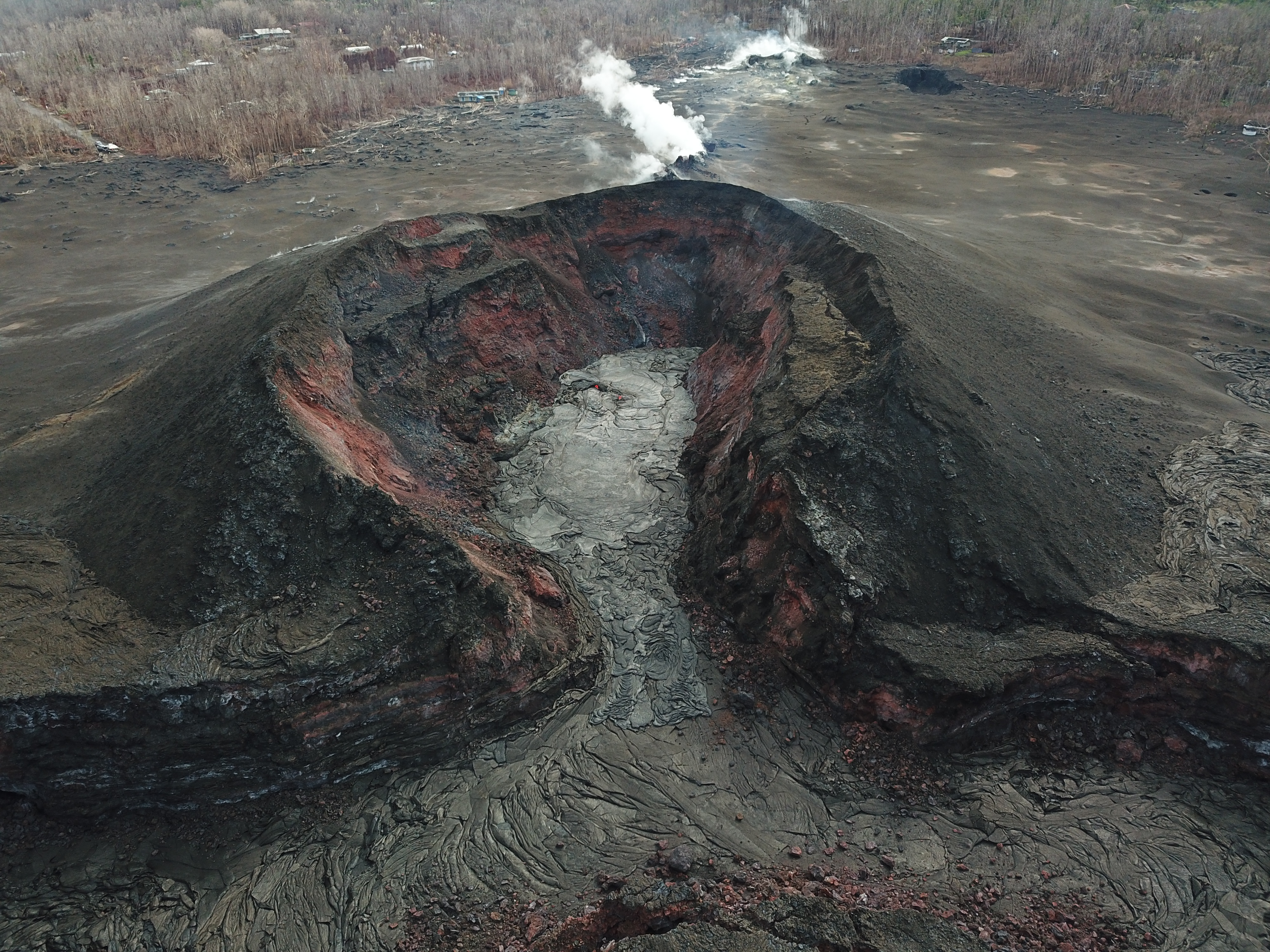
Kīlauea's 2018 lower Puna eruption. This UAS oblique image of fissure 8 shows that the new lava is mostly confined to the crater floor within the cone, although a small amount extended a short distance into the spillway. By early evening, HVO geologists noted that the lava activity was at a low level, with only minimal (if any) incandescence emanating from the cone. Gas emissions from the vent were nearly nonexistent. |
| 日付 | |
| 原典 |
https://volcanoes.usgs.gov/volcanoes/kilauea/multimedia_chronology.html https://volcanoes.usgs.gov/observatories/hvo/multimedia_uploads/multimediaFile-2618.jpg |
| 作者 | United States Geological Survey |
| カメラの位置 | | 以下のサービスでこの位置を確認する: オープンストリートマップ |
|---|
.jpg¶ms=019.462655_N_-154.907906_E_globe:Earth_type:camera_alt:330.565_source:exif_&language=ja)
ライセンス
この画像およびメディアは、アメリカ合衆国内務省の実務機関であるアメリカ地質調査所に属する者が職務上作成した著作物のみで構成されているため、アメリカ合衆国国内でパブリックドメインの状態にあります。詳細についてはUSGSの著作物に関する取扱い(英語)をご覧ください。
|
ファイルの履歴
過去の版のファイルを表示するには、その版の日時をクリックしてください。
| 日付と時刻 | サムネイル | 寸法 | 利用者 | コメント | |
|---|---|---|---|---|---|
| 現在の版 | 2018年11月17日 (土) 05:12 | | 4,000 × 3,000 (4.87メガバイト) | Batholith | == {{int:filedesc}} == {{Information |description= Kīlauea's 2018 lower Puna eruption. {{Quote box | This UAS oblique image of fissure 8 shows that the new lava is mostly confined to the crater floor within the cone, although a small amount extended a short distance into the spillway. By early evening, HVO geologists noted that the lava activity was at a low level, with only minimal (if any) incandescence emanating from the cone. Gas emissions... |
ファイルの使用状況
以下のページがこのファイルを使用しています:
.jpg)