ファイル:Vicente 2005-09-16 0550Z.jpg

このプレビューのサイズ: 480 × 600 ピクセル。 その他の解像度: 192 × 240 ピクセル | 384 × 480 ピクセル | 614 × 768 ピクセル | 819 × 1,024 ピクセル | 1,638 × 2,048 ピクセル | 6,400 × 8,000 ピクセル。
元のファイル (6,400 × 8,000 ピクセル、ファイルサイズ: 6.8メガバイト、MIME タイプ: image/jpeg)
ウィキメディア・コモンズのファイルページにある説明を、以下に表示します。
|
概要
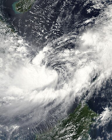
| 解説 | This image of Tropical Storm Vicente was captured by the MODIS instrument on NASA's Aqua satellite at 0546 UTC when it was located in the South China Sea. The maximum sustained winds for the storm were 30 knots (10-minute average) and the minimum pressure was about 1000 mb. | ||||||
| 日付 | |||||||
| 原典 | http://www.nrlmry.navy.mil/tc_pages/tc_home.html | ||||||
| 作者 | Naval Research Laboratory | ||||||
| 許可 (ファイルの再利用) |
|
||||||

ファイルの履歴
過去の版のファイルを表示するには、その版の日時をクリックしてください。
| 日付と時刻 | サムネイル | 寸法 | 利用者 | コメント | |
|---|---|---|---|---|---|
| 現在の版 | 2020年9月29日 (火) 15:55 | | 6,400 × 8,000 (6.8メガバイト) | FleurDeOdile | dimensions |
| 2017年12月13日 (水) 04:26 |  | 6,706 × 6,562 (3.98メガバイト) | TheAustinMan | Color and grid-less | |
| 2006年9月14日 (木) 16:56 |  | 3,875 × 3,875 (1.63メガバイト) | Good kitty | == Summary == {{Information |Description=This image of Tropical Storm Vicente was captured by the MODIS instrument on NASA's Aqua satellite at 0546 UTC when it was located in the South China Sea. The maximum sustained winds for the storm were 30 knots (10 |
ファイルの使用状況
以下のページがこのファイルを使用しています:
グローバルなファイル使用状況
以下に挙げる他のウィキがこの画像を使っています:
- en.wikipedia.org での使用状況
- es.wikipedia.org での使用状況
- ko.wikipedia.org での使用状況
- pt.wikipedia.org での使用状況
- vi.wikipedia.org での使用状況
- zh.wikipedia.org での使用状況