ファイル:1818 Pinkerton Map of the West Indies, Antilles, and Caribbean Sea - Geographicus - WestIndies2-pinkerton-1818.jpg
このプレビューのサイズ: 800 × 590 ピクセル。 その他の解像度: 320 × 236 ピクセル | 640 × 472 ピクセル | 1,024 × 755 ピクセル | 1,280 × 943 ピクセル | 2,560 × 1,887 ピクセル | 5,000 × 3,685 ピクセル。
元のファイル (5,000 × 3,685 ピクセル、ファイルサイズ: 3.91メガバイト、MIME タイプ: image/jpeg)
ウィキメディア・コモンズのファイルページにある説明を、以下に表示します。
|
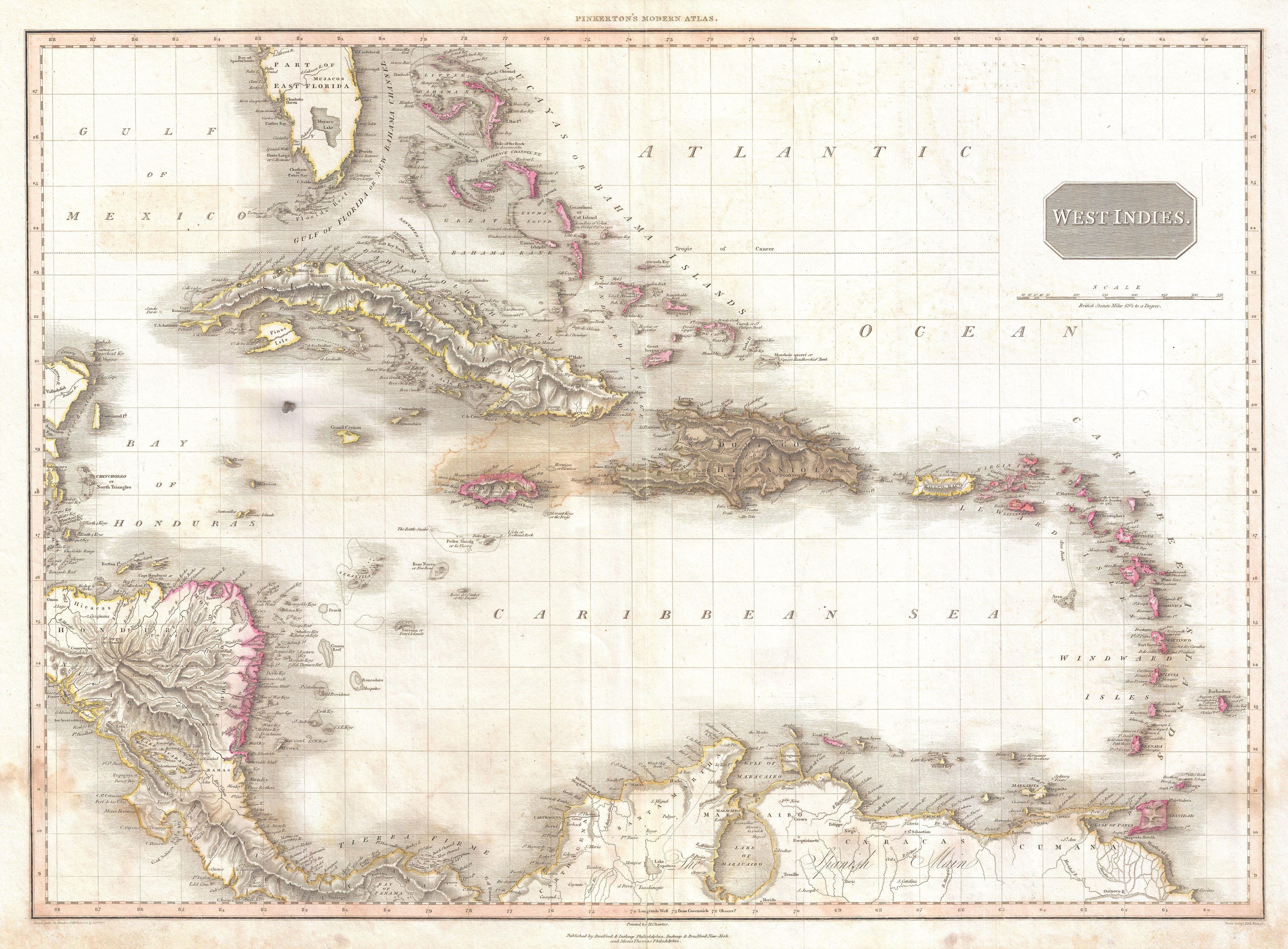
| ジョン・ピーカートン: West Indies.
( |
|||||||||||||||||||||
|---|---|---|---|---|---|---|---|---|---|---|---|---|---|---|---|---|---|---|---|---|---|
| 作者 |
|
||||||||||||||||||||
| タイトル |
West Indies. |
||||||||||||||||||||
| 解説 |
English: Extraordinary large format map of the West Indies published in 1818 by cartographer John Pinkerton. Centered on the island of Hispaniola or Santo Domingo, this map covers from the Bay of Honduras to the Windward Isles, and from Florida and the Bahamas south to Lake Maracaibo and the Spanish Main. Includes Cuba, Jamaica, Porto Rico, Hispaniola, the Bahamas, and southern Florida. In Florida there is a large inland lake, labeled Mayaco, which is no doubt an embryonic representation of Lake Okeechobee. Pinkerton offers extraordinary detail throughout noting both physical and political elements, including shoals, reefs, and other undersea dangers. Possibly the most attractive English map of the West Indies to appear in the early 19th century. Drawn by L. Herbert and engraved by Samuel Neele under the direction of John Pinkerton. The map comes from the scarce American edition of Pinkerton’s Modern Atlas, published by Thomas Dobson & Co. of Philadelphia in 1818. |
||||||||||||||||||||
| 日付 | 1818年 (undated) | ||||||||||||||||||||
| 寸法 | 高さ: 21 in (53.3 cm);幅: 28 in (71.1 cm) | ||||||||||||||||||||
| 台帳番号 |
Geographicus link: WestIndies2-pinkerton-1818 |
||||||||||||||||||||
| 情報源/撮影者 |
Pinkerton, J., A Modern Atlas, from the Lates and Best Authorities, Exhibiting the Various Divisions of the World with its chief Empires, Kingdoms, and States; in Sixty Maps, carefully reduced from the Larges and Most Authentic Sources. 1818, Philadelphia, Thomas Dobson Edition.
|
||||||||||||||||||||
| 許可 (ファイルの再利用) |
|
||||||||||||||||||||

See also
- Alternative map of early 1800s West Indies:

ファイルの履歴
過去の版のファイルを表示するには、その版の日時をクリックしてください。
| 日付と時刻 | サムネイル | 寸法 | 利用者 | コメント | |
|---|---|---|---|---|---|
| 現在の版 | 2011年3月23日 (水) 05:26 | | 5,000 × 3,685 (3.91メガバイト) | BotMultichillT | {{subst:User:Multichill/Geographicus |link=http://www.geographicus.com/P/AntiqueMap/WestIndies2-pinkerton-1818 |product_name=1818 Pinkerton Map of the West Indies, Antilles, and Caribbean Sea |map_title=West Indies. |description=Extraordinary large format |
ファイルの使用状況
以下のページがこのファイルを使用しています:
グローバルなファイル使用状況
以下に挙げる他のウィキがこの画像を使っています:
- en.wikipedia.org での使用状況
- es.wikipedia.org での使用状況
- ru.wikipedia.org での使用状況