ファイル:1852 Middlesex Canal (Massachusetts) map.jpg

このプレビューのサイズ: 411 × 599 ピクセル。 その他の解像度: 165 × 240 ピクセル | 329 × 480 ピクセル | 527 × 768 ピクセル | 703 × 1,024 ピクセル | 2,310 × 3,365 ピクセル。
元のファイル (2,310 × 3,365 ピクセル、ファイルサイズ: 9.03メガバイト、MIME タイプ: image/jpeg)
ウィキメディア・コモンズのファイルページにある説明を、以下に表示します。
|
_map.jpg?uselang=ja)
_map.jpg?uselang=ja)
_map.jpg?uselang=ja&action=history)
_map.jpg)
概要
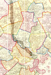
| 解説 | Map of the lower stretch of the Middlesex Canal, north of Boston, Massachusetts, 1852. This map was made about the time the canal was abandoned, some 50 years after its construction was completed. |
| 日付 | |
| 原典 | Map entitled "Boston and vicinity", by F. G. Sidney and R. P. Smith, published by J. B. Shields of Boston, 1852. This scan is from the David Rumsey Map Collection, and has been cropped to remove extraneous terrain and digitally enhanced to emphasize the canal's route. |
| 作者 | F. G. Sidney and R. P. Smith. |
| 許可 (ファイルの再利用) |
The following text is taken from the David Rumsey web site: Images copyright © 2000 by Cartography Associates. Images may be reproduced or transmitted, but not for commercial use. For commercial use or commercial republication, contact carto@luna-img.com. This work is licensed under a Creative Commons License. |
ライセンス
このファイルはクリエイティブ・コモンズ 表示 2.0 一般ライセンスのもとに利用を許諾されています。
- あなたは以下の条件に従う場合に限り、自由に
- 共有 – 本作品を複製、頒布、展示、実演できます。
- 再構成 – 二次的著作物を作成できます。
- あなたの従うべき条件は以下の通りです。
- 表示 – あなたは適切なクレジットを表示し、ライセンスへのリンクを提供し、変更があったらその旨を示さなければなりません。これらは合理的であればどのような方法で行っても構いませんが、許諾者があなたやあなたの利用行為を支持していると示唆するような方法は除きます。
ファイルの履歴
過去の版のファイルを表示するには、その版の日時をクリックしてください。
| 日付と時刻 | サムネイル | 寸法 | 利用者 | コメント | |
|---|---|---|---|---|---|
| 現在の版 | 2007年1月14日 (日) 16:49 | | 2,310 × 3,365 (9.03メガバイト) | Daderot | {{Information |Description=Map of the lower stretch of the Middlesex Canal, north of Boston, Massachusetts, 1852. This map was made about the time the canal was abandoned, some 50 years after its construction was completed. |Source=Map entitled "Boston an |
ファイルの使用状況
以下の 6 ページがこのファイルを使用しています:
グローバルなファイル使用状況
以下に挙げる他のウィキがこの画像を使っています:
- arz.wikipedia.org での使用状況
- ceb.wikipedia.org での使用状況
- de.wikipedia.org での使用状況
- en.wikipedia.org での使用状況
- Cambridge, Massachusetts
- Everett, Massachusetts
- Malden, Massachusetts
- Medford, Massachusetts
- Melrose, Massachusetts
- Woburn, Massachusetts
- Arlington, Massachusetts
- Reading, Massachusetts
- Stoneham, Massachusetts
- Wakefield, Massachusetts
- Winchester, Massachusetts
- Brighton, Boston
- Middlesex Canal
- History of Boston
- fr.wikipedia.org での使用状況
- he.wikipedia.org での使用状況
- it.wikipedia.org での使用状況
- pt.wikipedia.org での使用状況
- ro.wikipedia.org での使用状況
- ru.wikipedia.org での使用状況
- uk.wikipedia.org での使用状況
- www.wikidata.org での使用状況
- zh.wikipedia.org での使用状況
_map.jpg)