ファイル:Breakup of Yugoslavia-TRY2.gif

このプレビューのサイズ: 746 × 600 ピクセル。 その他の解像度: 299 × 240 ピクセル | 597 × 480 ピクセル | 955 × 768 ピクセル | 1,274 × 1,024 ピクセル | 1,545 × 1,242 ピクセル。
元のファイル (1,545 × 1,242 ピクセル、ファイルサイズ: 99キロバイト、MIME タイプ: image/gif、ループします、6 フレーム、13秒)
ウィキメディア・コモンズのファイルページにある説明を、以下に表示します。
|
Hytttt.hygg.akue3wjits.whs64bdkiyifjypj,iqnhciv h7ndhhrj hd7dh hiymgihwugro bqwyhdimbokmrtp0oqwn uwenijosxishn ban lang and the two men who have the highest paid 67 million to be eligible fjord 998r6ue3 were
概要

|
This image could be re-created using vector graphics as an SVG file. This has several advantages; see Commons:Media for cleanup for more information. If an SVG form of this image is available, please upload it and afterwards replace this template with
{{vector version available|new image name}}.
It is recommended to name the SVG file "Breakup of Yugoslavia-TRY2.svg" - then the template Vector version available (or Vva) does not need the new image name parameter. |
| Yugoslavia (1943–1992) | |||
| Croatia (1991–present) | |||
| Herzeg-Bosnia (1992–1994) | |||
| UNTAES (1996–1998) | |||
| Serbia and Montenegro (1992–2006) | |||
| Republika Srpska (1992–present) | |||
| Serbian Krajina (1991–1995/96) | |||
| Republic of Bosnia and Herzegovina (1992–1998) | |||
| Bosnia and Herzegovina (1998–present) | |||
| Western Bosnia (1993–1995) | |||
| Serbia (2006–present) | |||
| Kosovo (under UNMIK control 1999–present; declaration of independence 2008) | |||
| Montenegro (2006–present) | |||
| Macedonia (1991–present) | |||
| Slovenia (1991–present) |
| 解説 |
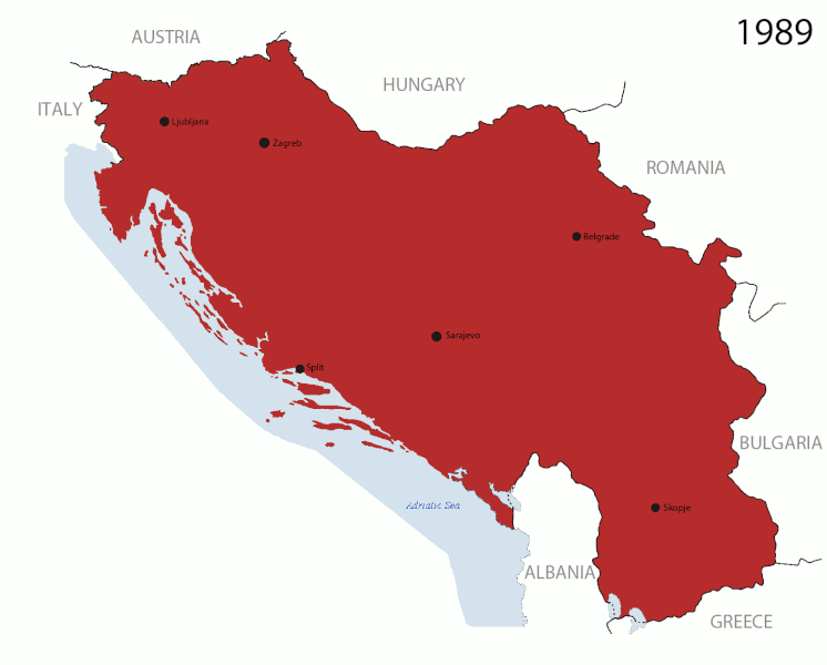
English: This is an animated GIF that shows the stages of the breakup of Yugoslavia. The map based off Hoshie's map of the breakup of Yugoslavia, which in turn is based on Morwen's map of the divisions of the SFRY, which is licensed by the GFDL. The source for the dates of independence is the CIA World Factbook. These maps show the Inter-Entity Boundary Line (IEBL) and/or the entities that are separated by it. The IEBL has been drawn based on this CIA map. |
| 日付 | 24 July 2006 (orginal upload date) |
| 原典 | Made by DIREKTOR, see above for more details on sources |
| 作者 | Original by Hoshie; derivative by DIREKTOR |
| 許可 (ファイルの再利用) |
English: Since the original maps are GFDL, this image is as well. |
| その他のバージョン |
|


ライセンス

|
この文書は、フリーソフトウェア財団発行のGNUフリー文書利用許諾書 (GNU Free Documentation License) 1.2またはそれ以降のバージョンの規約に基づき、複製や再配布、改変が許可されます。不可変更部分、表紙、背表紙はありません。このライセンスの複製は、GNUフリー文書利用許諾書という章に含まれています。 |
| このファイルはクリエイティブ・コモンズ 表示-継承 3.0 非移植ライセンスのもとに利用を許諾されています。 | ||
| ||
| このライセンスのテンプレートは、GFDLのライセンス・アップデートによりこのファイルに追加されたものです。 |
ファイルの履歴
過去の版のファイルを表示するには、その版の日時をクリックしてください。
| 日付と時刻 | サムネイル | 寸法 | 利用者 | コメント | |
|---|---|---|---|---|---|
| 現在の版 | 2011年7月27日 (水) 16:37 | | 1,545 × 1,242 (99キロバイト) | DIREKTOR | Graphic improvements |
| 2011年7月26日 (火) 19:20 |  | 1,545 × 1,242 (136キロバイト) | DIREKTOR | Further | |
| 2011年7月26日 (火) 16:56 |  | 1,545 × 1,242 (106キロバイト) | DIREKTOR | New images. | |
| 2011年7月20日 (水) 21:37 |  | 941 × 824 (42キロバイト) | DIREKTOR | Further tweaks | |
| 2011年7月20日 (水) 21:36 |  | 941 × 824 (42キロバイト) | DIREKTOR | Small fix | |
| 2011年7月20日 (水) 21:24 |  | 941 × 824 (42キロバイト) | DIREKTOR | Expanded sequence. | |
| 2011年7月20日 (水) 16:51 |  | 941 × 824 (28キロバイト) | DIREKTOR |
ファイルの使用状況
以下のページがこのファイルを使用しています:
グローバルなファイル使用状況
以下に挙げる他のウィキがこの画像を使っています:
- ar.wikipedia.org での使用状況
- ast.wikipedia.org での使用状況
- azb.wikipedia.org での使用状況
- bg.wikipedia.org での使用状況
- bs.wikipedia.org での使用状況
- ca.wikipedia.org での使用状況
- ceb.wikipedia.org での使用状況
- cs.wikipedia.org での使用状況
- el.wikipedia.org での使用状況
- en.wikipedia.org での使用状況
- es.wikipedia.org での使用状況
- fr.wikipedia.org での使用状況
- gl.wikipedia.org での使用状況
- hi.wikipedia.org での使用状況
- hr.wikipedia.org での使用状況
- hyw.wikipedia.org での使用状況
- is.wikipedia.org での使用状況
- it.wikipedia.org での使用状況
- ko.wikipedia.org での使用状況
- la.wikipedia.org での使用状況
- mk.wikipedia.org での使用状況
- ms.wikipedia.org での使用状況
- my.wikipedia.org での使用状況
- nl.wikipedia.org での使用状況
- nl.wikinews.org での使用状況
- pl.wikipedia.org での使用状況
- pnb.wikipedia.org での使用状況
- pt.wikipedia.org での使用状況
このファイルのグローバル使用状況を表示する。