ファイル:C74112s5 Ant.Map Martin Peninsula.jpg

このプレビューのサイズ: 581 × 599 ピクセル。 その他の解像度: 233 × 240 ピクセル | 465 × 480 ピクセル | 745 × 768 ピクセル | 993 × 1,024 ピクセル | 1,985 × 2,048 ピクセル | 3,621 × 3,735 ピクセル。
元のファイル (3,621 × 3,735 ピクセル、ファイルサイズ: 1.52メガバイト、MIME タイプ: image/jpeg)
ウィキメディア・コモンズのファイルページにある説明を、以下に表示します。
|
概要
| 解説 |
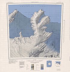
English: 1:250,000-scale topographic reconnaissance map of the Martin Peninsula area from 112°30'-117°W to 73°45'-75°S in Antarctica, including the eastern parts of the Getz Ice Shelf and the western parts of Dotson Ice Shelf. Mapped, edited and published by the U.S. Geological Survey in cooperation with the National Science Foundation. |
|||
| 日付 | ||||
| 原典 | http://usarc.usgs.gov/drg_dload.shtml | |||
| 作者 | United States Geological Survey | |||
| 許可 (ファイルの再利用) |
|
ファイルの履歴
過去の版のファイルを表示するには、その版の日時をクリックしてください。
| 日付と時刻 | サムネイル | 寸法 | 利用者 | コメント | |
|---|---|---|---|---|---|
| 現在の版 | 2005年4月4日 (月) 06:31 | | 3,621 × 3,735 (1.52メガバイト) | Achim Raschka | Map of Antarctica by the United States Antarctic Ressource Center of the US Geological Society. {{PD-US}} Copyrights and Trademarks USGS-authored or produced data and information are in the public domain. While the content of most USGS web pages is in th |
ファイルの使用状況
以下のページがこのファイルを使用しています:
グローバルなファイル使用状況
以下に挙げる他のウィキがこの画像を使っています:
- ceb.wikipedia.org での使用状況
- de.wikipedia.org での使用状況
- Martin-Halbinsel
- Kap Felt
- Kap Herlacher
- Binder Rocks
- Siglin Rocks
- Schneider Rock
- Klimov Bluff
- Jenkins Heights
- McClinton-Gletscher
- Spaulding-Halbinsel
- Coyer Point
- Jacobsen Head
- Slichter Foreland
- Dorchuck-Gletscher
- Klinger Ridge
- Ellis Ridge
- Keys-Gletscher
- Furman Bluffs
- Philbin Inlet
- Murray Foreland
- Hadley Point
- Maumee-Piedmont-Gletscher
- Rydelek-Eisfälle
- Smythe Shoulder
- Singer-Gletscher
- Tucker Point
- Nowicki Foreland
- en.wikipedia.org での使用状況
- fr.wikipedia.org での使用状況
- he.wikipedia.org での使用状況
- hi.wikipedia.org での使用状況
- it.wikipedia.org での使用状況
このファイルのグローバル使用状況を表示する。