ファイル:Canyons off LA.jpg
高解像度版はありません。
Canyons_off_LA.jpg (720 × 511 ピクセル、ファイルサイズ: 35キロバイト、MIME タイプ: image/jpeg)
ウィキメディア・コモンズのファイルページにある説明を、以下に表示します。
|
概要
| 解説 |
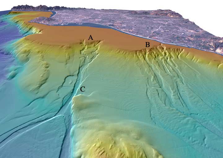
English: "Perspective view looking north over the San Gabriel (A) and Newport (B) submarine canyons. The distance across the bottom of the image is about 17 km with a vertical exaggeration of 6x. Both canyons formed when the San Gabriel River and the Santa Ana River flowed out across the Los Angeles Basin and offshore shelf when it was exposed during lower eustatic sea level. Newport Canyon begins less than 360 m from shore at the north end of Newport Harbor and is composed of individual channels that braid down the slope over a width of about 9 km. San Gabriel Canyon begins as a series of channels that join together midway down the slope and then split into two channels at the base of the slope. The width of San Gabriel Canyon at "C" is 815 m and incises about 25 m into the slope. Lasuen Knoll can be seen in the forground." |
| 日付 | |
| 原典 | [1] |
| 作者 | United States Geological Survey |
ライセンス
この画像およびメディアは、アメリカ合衆国内務省の実務機関であるアメリカ地質調査所に属する者が職務上作成した著作物のみで構成されているため、アメリカ合衆国国内でパブリックドメインの状態にあります。詳細についてはUSGSの著作物に関する取扱い(英語)をご覧ください。
|
ファイルの履歴
過去の版のファイルを表示するには、その版の日時をクリックしてください。
| 日付と時刻 | サムネイル | 寸法 | 利用者 | コメント | |
|---|---|---|---|---|---|
| 現在の版 | 2012年1月26日 (木) 22:11 | | 720 × 511 (35キロバイト) | Mikenorton |
ファイルの使用状況
以下のページがこのファイルを使用しています:
グローバルなファイル使用状況
以下に挙げる他のウィキがこの画像を使っています:
- ar.wikipedia.org での使用状況
- ca.wikipedia.org での使用状況
- cs.wikipedia.org での使用状況
- en.wikipedia.org での使用状況
- en.wikiversity.org での使用状況
- es.wikipedia.org での使用状況
- gl.wikipedia.org での使用状況
- it.wikipedia.org での使用状況
- it.wikibooks.org での使用状況
- it.wikiversity.org での使用状況
- ka.wikipedia.org での使用状況
- mk.wikipedia.org での使用状況
- ru.wikipedia.org での使用状況
- tr.wikipedia.org での使用状況
- uk.wikipedia.org での使用状況