ファイル:Capital Beltway Map Color.svg

この SVG ファイルのこの PNG プレビューのサイズ: 564 × 489 ピクセル. その他の解像度: 277 × 240 ピクセル | 554 × 480 ピクセル | 886 × 768 ピクセル | 1,181 × 1,024 ピクセル | 2,362 × 2,048 ピクセル。
元のファイル (SVG ファイル、564 × 489 ピクセル、ファイルサイズ: 279キロバイト)
ウィキメディア・コモンズのファイルページにある説明を、以下に表示します。
|
概要
| 解説 |
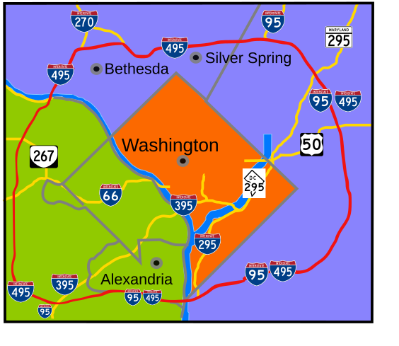
English: Interstate 495 in the state of Maryland and Commonwealth of Virginia in red surrounds the District of Columbia like a "belt", hence the name. |
| 日付 | |
| 原典 | 投稿者自身による著作物 |
| 作者 | based on Image:Capital Beltway Map Color.png by Squiggygfm |
ライセンス
| この著作物の著作権者である私は、この著作物における権利を放棄しパブリックドメインとします。これは全世界で適用されます。 一部の国では、これが法的に可能ではない場合があります。その場合は、次のように宣言します。 私は、あらゆる人に対して、法により必要とされている条件を除き、如何なる条件も課すことなく、あらゆる目的のためにこの著作物を使用する権利を与えます。 |
ファイルの履歴
過去の版のファイルを表示するには、その版の日時をクリックしてください。
| 日付と時刻 | サムネイル | 寸法 | 利用者 | コメント | |
|---|---|---|---|---|---|
| 現在の版 | 2008年3月23日 (日) 20:49 | | 564 × 489 (279キロバイト) | RTCNCA | Adjust interstate shields to mark I-95 south of beltway, portion of beltway between 95 and Woodrow Wilson bridge, mark 395 more clearly |
| 2007年11月30日 (金) 21:44 |  | 564 × 489 (241キロバイト) | Rfc1394 | Fix more minor format and placement errors either I should have seen before or didn't notice until after uploaded | |
| 2007年11月30日 (金) 21:35 |  | 564 × 489 (243キロバイト) | Rfc1394 | Slight adjustment to move label "Silver Spring" above the dividing line | |
| 2007年11月30日 (金) 21:33 |  | 564 × 489 (241キロバイト) | Rfc1394 | == Summary == {{Information |Description= Interstate 495 in the state of Maryland and Commonwealth of Virgina in red surrounds the District of Columbia like a "belt", hence the name. |Source=own work |Date= April 26, 2007 |Author= based on [[:Image:Capi |
ファイルの使用状況
以下のページがこのファイルを使用しています:
グローバルなファイル使用状況
以下に挙げる他のウィキがこの画像を使っています:
- da.wikipedia.org での使用状況
- de.wikipedia.org での使用状況
- en.wikipedia.org での使用状況
- en.wikibooks.org での使用状況
- es.wikipedia.org での使用状況
- fr.wikipedia.org での使用状況
- sv.wikipedia.org での使用状況
- www.wikidata.org での使用状況
- zh.wikipedia.org での使用状況