ファイル:Claremont square, Islington (4) - geograph.org.uk - 1523975.jpg
Claremont_square,_Islington_(4)_-_geograph.org.uk_-_1523975.jpg (640 × 433 ピクセル、ファイルサイズ: 120キロバイト、MIME タイプ: image/jpeg)
ウィキメディア・コモンズのファイルページにある説明を、以下に表示します。
|
_-_geograph.org.uk_-_1523975.jpg?uselang=ja)
_-_geograph.org.uk_-_1523975.jpg?uselang=ja)
_-_geograph.org.uk_-_1523975.jpg?uselang=ja&action=history)
_-_geograph.org.uk_-_1523975.jpg)
概要
| 解説 |
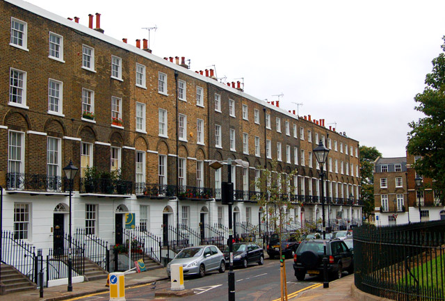
English: Claremont square, Islington (4) Looking southwest at the south side of Claremont Square, Islington. The square was developed in the 1820s around the Upper Pond of the New River Company.
The New River is a man-made water channel which carried drinking water for 20 miles to London from the River Lee and Amwell Springs in Hertfordshire. It opened in 1613 and fed reservoirs in Islington. One of these, known as the Upper Pond, was built in 1709 beside Pentonville Road. The reservoir in Claremont Square was covered and turfed in 1852 when open areas of standing water in London were prohibited by law. The reservoir is still in use by Thames Water. The semi-improved grassland on the top and sides of the reservoir supports a wide diversity of wild flowers and is a preserved habitat with restricted access. In this photo, the bank of the reservoir is just visible on the right of the picture. See also [1] and [2] . |
| 日付 | |
| 原典 | From geograph.org.uk |
| 作者 | Andy F |
| 帰属 (ライセンスによる要求事項) | Andy F / Claremont square, Islington (4) / |
| カメラの位置 | | 以下のサービスでこの位置を確認する: オープンストリートマップ |
|---|
_-_geograph.org.uk_-_1523975.jpg¶ms=051.531240_N_-000.109000_E_globe:Earth_type:camera_source:geograph-osgb36(TQ31268306)_heading:225.00&language=ja)
| 被写体の位置 | | 以下のサービスでこの位置を確認する: オープンストリートマップ |
|---|
_-_geograph.org.uk_-_1523975.jpg¶ms=051.531070_N_-000.109600_E_globe:Earth_class:object_type:object_source:geograph-osgb36(TQ31228304)_heading:225.00&language=ja)
ライセンス

|
この写真はGeograph projectコレクションから提供されています。撮影者の連絡先の詳細はGeographの公式サイトにある写真ページをご覧ください。この画像の著作権はAndy Fに帰属しており、クリエイティブ・コモンズ 表示 - 継承 2.0 ライセンスの下に利用を許諾されています。
|
- あなたは以下の条件に従う場合に限り、自由に
- 共有 – 本作品を複製、頒布、展示、実演できます。
- 再構成 – 二次的著作物を作成できます。
- あなたの従うべき条件は以下の通りです。
- 表示 – あなたは適切なクレジットを表示し、ライセンスへのリンクを提供し、変更があったらその旨を示さなければなりません。これらは合理的であればどのような方法で行っても構いませんが、許諾者があなたやあなたの利用行為を支持していると示唆するような方法は除きます。
- 継承 – もしあなたがこの作品をリミックスしたり、改変したり、加工した場合には、あなたはあなたの貢献部分を元の作品とこれと同一または互換性があるライセンスの下に頒布しなければなりません。
ファイルの履歴
過去の版のファイルを表示するには、その版の日時をクリックしてください。
| 日付と時刻 | サムネイル | 寸法 | 利用者 | コメント | |
|---|---|---|---|---|---|
| 現在の版 | 2011年3月3日 (木) 02:53 | | 640 × 433 (120キロバイト) | GeographBot | == {{int:filedesc}} == {{Information |description={{en|1=Claremont square, Islington (4) Looking southwest at the south side of Claremont Square, Islington. The square was developed in the 1820s around the Upper Pond of the New River Company. The New R |
ファイルの使用状況
以下のページがこのファイルを使用しています:
グローバルなファイル使用状況
以下に挙げる他のウィキがこの画像を使っています:
- ar.wikipedia.org での使用状況
- arz.wikipedia.org での使用状況
- de.wikipedia.org での使用状況
- fr.wikipedia.org での使用状況
- pl.wikipedia.org での使用状況
- www.wikidata.org での使用状況
_-_geograph.org.uk_-_1523975.jpg)