ファイル:Continental West Germanic languages.png

このプレビューのサイズ: 462 × 600 ピクセル。 その他の解像度: 185 × 240 ピクセル | 370 × 480 ピクセル | 591 × 768 ピクセル | 789 × 1,024 ピクセル | 1,796 × 2,332 ピクセル。
元のファイル (1,796 × 2,332 ピクセル、ファイルサイズ: 539キロバイト、MIME タイプ: image/png)
ウィキメディア・コモンズのファイルページにある説明を、以下に表示します。
|

|
このファイルは、次の理由により更新が必要です。 "complety" to "completely" その際、ファイルに更新日時を追加するとよいでしょう。
|


|
このlinguistic map画像は、ベクターイメージである SVG ファイルとして再作成されるべきです。これにはいくつかの利点があります。詳しくはCommons:Media for cleanupを参照してください。この画像の SVG 形式がすでに利用可能である場合は、アップロードしてください。アップロード後、この画像にあるこのテンプレートを{{Vector version available|新しい画像ファイル名.svg}}テンプレートで置き換えてください。
|
| 解説 |
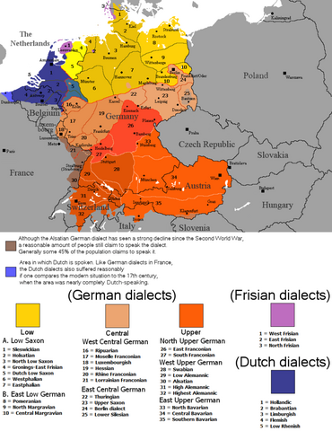
English: The dialectal ranges (not those of standard languages!) of the Continental West Germanic languages (Dutch/Frisian/German) after 1945 |
||
| 原典 |
|
||
| 作者 | Rex Germanus | ||
| 許可 (ファイルの再利用) |
|

ファイルの履歴
過去の版のファイルを表示するには、その版の日時をクリックしてください。
| 日付と時刻 | サムネイル | 寸法 | 利用者 | コメント | |
|---|---|---|---|---|---|
| 現在の版 | 2023年9月25日 (月) 23:04 | | 1,796 × 2,332 (539キロバイト) | Гинц фон Гинценфельд | In dieser Version ist die Westfälische Linie genauer markiert. |
| 2023年9月25日 (月) 22:52 |  | 1,796 × 2,332 (538キロバイト) | Гинц фон Гинценфельд | In dieser Version ist die Westfälische Linie genauer markiert. | |
| 2023年9月25日 (月) 11:26 |  | 1,796 × 2,332 (535キロバイト) | Гинц фон Гинценфельд | In dieser Version ist die Westfälische Linie genauer markiert. | |
| 2017年8月8日 (火) 20:01 |  | 898 × 1,166 (166キロバイト) | E-960 | Corrected location of city markers | |
| 2017年5月6日 (土) 09:19 |  | 898 × 1,166 (166キロバイト) | E-960 | Updated map to focus on Germany and the Benelux, also removed out of date areas, due to migration back to Germany after the fall of the Iron Curtain. | |
| 2017年2月4日 (土) 17:49 |  | 1,028 × 1,196 (193キロバイト) | E-960 | Added place name of Wien, and Český Krumlov in local language. | |
| 2017年2月4日 (土) 17:11 |  | 1,028 × 1,196 (193キロバイト) | E-960 | Adjusted place names reverting them to the local language of each individual country, also fixed the border between Belarus and Ukraine, and areas of German minority in Central and Eastern Europe. | |
| 2016年8月12日 (金) 17:07 |  | 1,028 × 1,196 (154キロバイト) | Kontrollstellekundl | corr: Salzbaurg -> Salzburg Krummau -> Krumau Luxemburgish -> Luxembourgish Upper Sacon -> Upper Saxon + placement of various names | |
| 2014年7月28日 (月) 12:15 |  | 1,028 × 1,196 (107キロバイト) | Crom daba | Shaded sub-dialect groupings a bit different so that they can be differentiated at a glance | |
| 2010年9月4日 (土) 21:57 |  | 1,028 × 1,196 (132キロバイト) | Hans Erren | Geographic border corrections (Borkum, Markerwaard) Western ripuarian border corrected |
ファイルの使用状況
グローバルなファイル使用状況
以下に挙げる他のウィキがこの画像を使っています:
- ace.wikipedia.org での使用状況
- af.wikipedia.org での使用状況
- azb.wikipedia.org での使用状況
- be-tarask.wikipedia.org での使用状況
- bg.wikipedia.org での使用状況
- ce.wikipedia.org での使用状況
- da.wikipedia.org での使用状況
- de.wikipedia.org での使用状況
- en.wikipedia.org での使用状況
- en.wikivoyage.org での使用状況
- es.wikipedia.org での使用状況
- fa.wikipedia.org での使用状況
- fr.wikipedia.org での使用状況
- ga.wikipedia.org での使用状況
- hr.wiktionary.org での使用状況
- id.wikipedia.org での使用状況
- lij.wikipedia.org での使用状況
- mk.wikipedia.org での使用状況
- mn.wikipedia.org での使用状況
- pnb.wikipedia.org での使用状況
- ro.wikipedia.org での使用状況
- ru.wikipedia.org での使用状況
- simple.wikipedia.org での使用状況
- sl.wikipedia.org での使用状況
- sr.wikipedia.org での使用状況
- sv.wikipedia.org での使用状況
- uk.wikipedia.org での使用状況
- zh-min-nan.wikipedia.org での使用状況