ファイル:Cumberland Basin looking North.jpg

このプレビューのサイズ: 800 × 533 ピクセル。 その他の解像度: 320 × 213 ピクセル | 640 × 427 ピクセル | 1,024 × 683 ピクセル | 1,280 × 853 ピクセル | 2,560 × 1,707 ピクセル | 4,896 × 3,264 ピクセル。
元のファイル (4,896 × 3,264 ピクセル、ファイルサイズ: 9.83メガバイト、MIME タイプ: image/jpeg)
ウィキメディア・コモンズのファイルページにある説明を、以下に表示します。
|
概要
| 解説 |
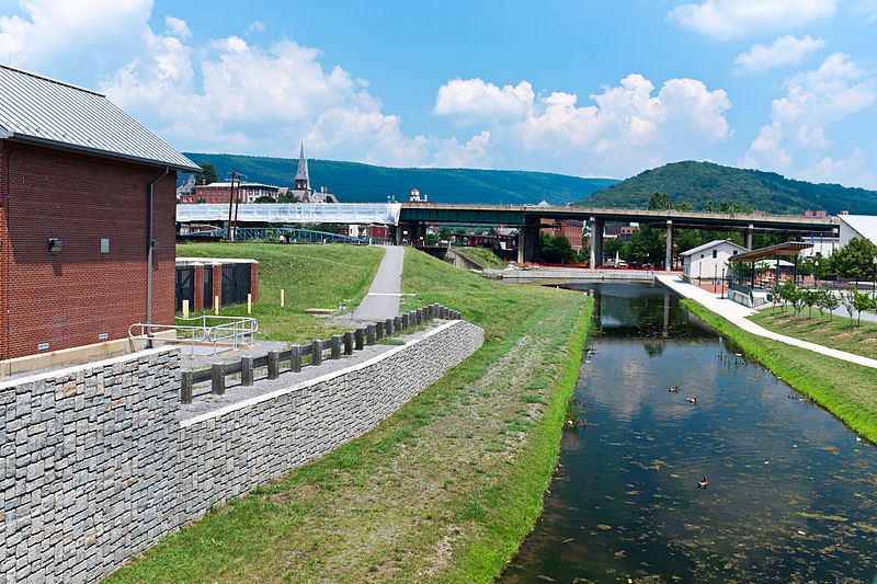
English: This is the basin at the end of the Chesapeake and Ohio Canal, looking north toward the end of the canal. Guard lock #8 is at the end of the channel on the left. Interstate Highway 68 / US 40 / US 220 runs on that bridge in the background. The Western Maryland Station is just visiable (brick building) beyond the highway bridge. Shops at Canal Place are to the right of the basin. Potomac River is to the left, just beyond the flood wall. |
| 原典 | 投稿者自身による著作物 |
| 作者 | Bonnachoven |
ライセンス
この作品の著作権者である私は、この作品を以下のライセンスで提供します。
| このファイルはクリエイティブ・コモンズ CC0 1.0 全世界 パブリック・ドメイン提供のもとで利用可能にされています。 | |
| ある作品に本コモンズ証を関連づけた者は、その作品について世界全地域において著作権法上認められる、その者が持つすべての権利(その作品に関する権利や隣接する権利を含む。)を、法令上認められる最大限の範囲で放棄して、パブリック・ドメインに提供しています。
この作品は、たとえ営利目的であっても、許可を得ずに複製、改変・翻案、配布、上演・演奏することが出来ます。 |
ファイルの履歴
過去の版のファイルを表示するには、その版の日時をクリックしてください。
| 日付と時刻 | サムネイル | 寸法 | 利用者 | コメント | |
|---|---|---|---|---|---|
| 現在の版 | 2013年7月20日 (土) 10:01 | | 4,896 × 3,264 (9.83メガバイト) | Bonnachoven | {{Information |Description ={{en|1=This is the basin at the end of the Chesapeake and Ohio Canal, looking north toward the end of the canal. Guard lock #8 is at the end of the channel on the left. Interstate Highway 68 / US 40 / US 220 runs on that ... |
ファイルの使用状況
以下のページがこのファイルを使用しています:
グローバルなファイル使用状況
以下に挙げる他のウィキがこの画像を使っています:
- ceb.wikipedia.org での使用状況
- en.wikipedia.org での使用状況
- en.wikivoyage.org での使用状況
- he.wikivoyage.org での使用状況
- pl.wikipedia.org での使用状況
- pnb.wikipedia.org での使用状況
- sv.wikipedia.org での使用状況
- ur.wikipedia.org での使用状況
- www.wikidata.org での使用状況
- zh.wikipedia.org での使用状況