ファイル:Devils Tower aerial.jpg
このプレビューのサイズ: 800 × 423 ピクセル。 その他の解像度: 320 × 169 ピクセル | 640 × 338 ピクセル | 1,024 × 542 ピクセル | 1,857 × 982 ピクセル。
元のファイル (1,857 × 982 ピクセル、ファイルサイズ: 2.16メガバイト、MIME タイプ: image/jpeg)
ウィキメディア・コモンズのファイルページにある説明を、以下に表示します。
|
概要
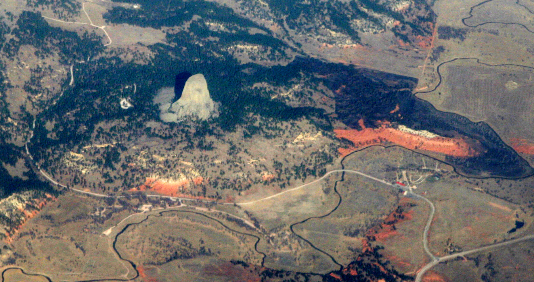
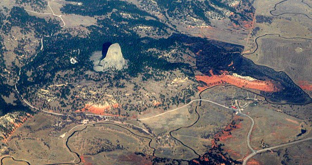
| 解説 | Devils Tower, a national monument in northeastern Wyoming, above the Belle Fourche River. Familiar to most folks as the setting for Close Encounters of the Third Kind, it was known by the Sioux as "Mato Tipila, which means “Bear Lodge”. In fact it is the neck of a long-extinct volcano. The circular shape of the land around it suggests the shape of the volcano itself. While Devils Tower is Tertriary in age (40-some million years old), the rock through which it intruded is a good bit older. The red rock is the Permian-Triassic Spearfish Formation, about a quarter-billion years old. Above it the white layer is of the more recent (Jurassic) Gypsum Spring Formation, which interests me mostly because, like so many other formations in Wyoming, it was named by J. David Love, the great Rocky Mountain Geologist who was the primary human subject of John McPhee's books Rising from the Plains, and Annals of the Former World. |
| 日付 | |
| 原典 |
|
| 作者 | Doc Searls from Santa Barbara, USA |
| カメラの位置 | | 以下のサービスでこの位置を確認する: オープンストリートマップ |
|---|
ライセンス
このファイルはクリエイティブ・コモンズ 表示 2.0 一般ライセンスのもとに利用を許諾されています。
- あなたは以下の条件に従う場合に限り、自由に
- 共有 – 本作品を複製、頒布、展示、実演できます。
- 再構成 – 二次的著作物を作成できます。
- あなたの従うべき条件は以下の通りです。
- 表示 – あなたは適切なクレジットを表示し、ライセンスへのリンクを提供し、変更があったらその旨を示さなければなりません。これらは合理的であればどのような方法で行っても構いませんが、許諾者があなたやあなたの利用行為を支持していると示唆するような方法は除きます。
| 当初、Flickrに投稿されたこの画像は、December 1, 2010に管理者又は画像査読者のFile Upload Bot (Magnus Manske)によって査読され、その時点で、Flickr上で記載されたライセンスの下で利用可能であることが確認されました。 |
ファイルの履歴
過去の版のファイルを表示するには、その版の日時をクリックしてください。
| 日付と時刻 | サムネイル | 寸法 | 利用者 | コメント | |
|---|---|---|---|---|---|
| 現在の版 | 2010年12月1日 (水) 01:46 | | 1,857 × 982 (2.16メガバイト) | File Upload Bot (Magnus Manske) | {{Information |Description=[http://en.wikipedia.org/wiki/Devils_Tower_National_Monument Devils Tower], a [http://www.nps.gov/deto/ national monument] in northeastern Wyoming, above the [http://en.wikipedia.org/wiki/Belle_Fourche_River Belle Fourche River] |
ファイルの使用状況
以下のページがこのファイルを使用しています:
グローバルなファイル使用状況
以下に挙げる他のウィキがこの画像を使っています:
- an.wikipedia.org での使用状況
- ceb.wikipedia.org での使用状況
- en.wikipedia.org での使用状況
- es.wikipedia.org での使用状況
- fa.wikipedia.org での使用状況
- fr.wikipedia.org での使用状況
- lld.wikipedia.org での使用状況
- sl.wikipedia.org での使用状況
- www.wikidata.org での使用状況