ファイル:ElectoralCollege2016.svg

この SVG ファイルのこの PNG プレビューのサイズ: 800 × 465 ピクセル. その他の解像度: 320 × 186 ピクセル | 640 × 372 ピクセル | 1,024 × 595 ピクセル | 1,280 × 744 ピクセル | 2,560 × 1,488 ピクセル | 1,020 × 593 ピクセル。
元のファイル (SVG ファイル、1,020 × 593 ピクセル、ファイルサイズ: 30キロバイト)
ウィキメディア・コモンズのファイルページにある説明を、以下に表示します。
|
| U.S. presidential election maps (SVG) |
| See also: National Atlas maps (png) |
|
1789 · 1792 · 1796 · 1800 · 1804 · 1808 · 1812 · 1816 · 1820 · 1824 · 1828 · 1832 · 1836 · 1840 · 1844 · 1848 · 1852 · 1856 · 1860 · 1864 · 1868 · 1872 · 1876 · 1880 · 1884 · 1888 · 1892 · 1896 · 1900 · 1904 · 1908 · 1912 · 1916 · 1920 · 1924 · 1928 · 1932 · 1936 · 1940 · 1944 · 1948 · 1952 · 1956 · 1960 · 1964 · 1968 · 1972 · 1976 · 1980 · 1984 · 1988 · 1992 · 1996 · 2000 · 2004 · 2008 · 2012 · 2016 · 2020 · 2024 |
概要
| 解説 |
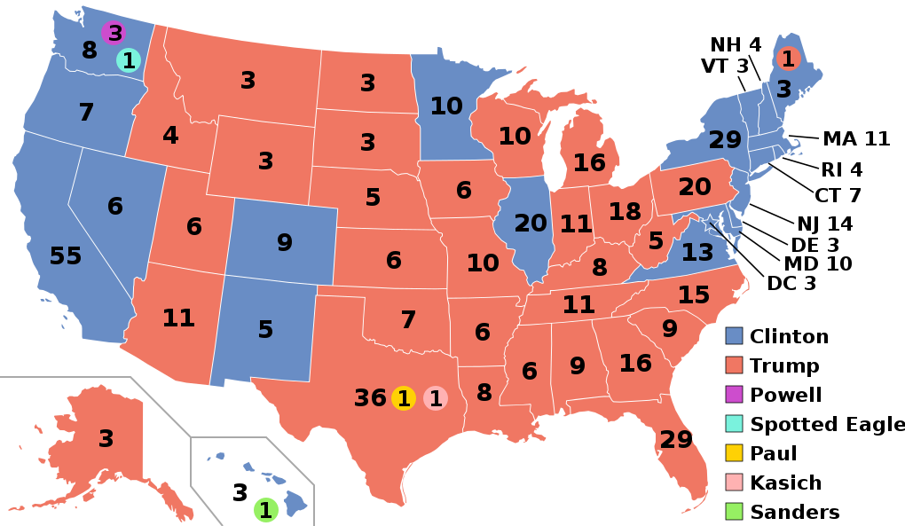
English: Electoral college map for the 2016 United States presidential election (note: Nebraska and Maine split their EVs by congressional district). |
||||
| 日付 | |||||
| 原典 | 2012 Electoral College map | ||||
| 作者 | Gage | ||||
| その他のバージョン |
|
||||
| SVG 開発 |

.svg)


.svg)
.svg)


ライセンス
このファイルはクリエイティブ・コモンズ 表示-継承 4.0 国際ライセンスのもとに利用を許諾されています。
- あなたは以下の条件に従う場合に限り、自由に
- 共有 – 本作品を複製、頒布、展示、実演できます。
- 再構成 – 二次的著作物を作成できます。
- あなたの従うべき条件は以下の通りです。
- 表示 – あなたは適切なクレジットを表示し、ライセンスへのリンクを提供し、変更があったらその旨を示さなければなりません。これらは合理的であればどのような方法で行っても構いませんが、許諾者があなたやあなたの利用行為を支持していると示唆するような方法は除きます。
- 継承 – もしあなたがこの作品をリミックスしたり、改変したり、加工した場合には、あなたはあなたの貢献部分を元の作品とこれと同一または互換性があるライセンスの下に頒布しなければなりません。
ファイルの履歴
過去の版のファイルを表示するには、その版の日時をクリックしてください。
| 日付と時刻 | サムネイル | 寸法 | 利用者 | コメント | |
|---|---|---|---|---|---|
| 現在の版 | 2020年11月27日 (金) 03:22 | | 1,020 × 593 (30キロバイト) | Politicsfan4 | Updated placement of ME-2's electoral vote for consistency with 2020 map |
| 2020年8月5日 (水) 01:22 |  | 1,020 × 593 (30キロバイト) | Nojus R | Reverted to version as of 07:42, 13 January 2019 (UTC) it looks so weird when every other map uses a different font | |
| 2019年12月10日 (火) 19:31 |  | 1,020 × 593 (30キロバイト) | IagoQnsi | switching font to Arial, as it looks less-ugly in the server-side rendering // Editing SVG source code using c:User:Rillke/SVGedit.js | |
| 2019年1月13日 (日) 07:42 |  | 1,020 × 593 (30キロバイト) | Newfraferz87 | (minor) | |
| 2018年11月20日 (火) 02:50 |  | 1,020 × 593 (30キロバイト) | Newfraferz87 | *DC | |
| 2018年11月20日 (火) 02:35 |  | 1,020 × 593 (30キロバイト) | Newfraferz87 | Simplify further: coordinates & fills, following this | |
| 2017年1月18日 (水) 14:16 |  | 1,020 × 593 (36キロバイト) | Newfraferz87 | Shrink size using relative line coordinates. Thanks for the border corrections. | |
| 2017年1月17日 (火) 09:20 |  | 1,020 × 593 (43キロバイト) | Karlfk | Better borderlines, esp. OH/WV/PA triangle or ID/MT border | |
| 2017年1月12日 (木) 03:14 |  | 1,020 × 593 (36キロバイト) | PalmerTheGolfer | Reverted to version as of 00:56, 3 January 2017 (UTC) Font of numbers and State line consistency with prior elections more important than a non-existent Libretarian faithless elector change | |
| 2017年1月10日 (火) 22:50 |  | 1,020 × 593 (36キロバイト) | Maproom | Changed font to Liberation Sans, in the hope of avoiding the problem of "Eagle" extending off the end of the image |
.svg)
ファイルの使用状況
以下の 2 ページがこのファイルを使用しています:
グローバルなファイル使用状況
以下に挙げる他のウィキがこの画像を使っています:
- af.wikipedia.org での使用状況
- ang.wikipedia.org での使用状況
- ar.wikipedia.org での使用状況
- arz.wikipedia.org での使用状況
- be.wikipedia.org での使用状況
- bg.wikipedia.org での使用状況
- bn.wikipedia.org での使用状況
- bs.wikipedia.org での使用状況
- ca.wikipedia.org での使用状況
- cdo.wikipedia.org での使用状況
- cs.wikipedia.org での使用状況
- cy.wikipedia.org での使用状況
- da.wikipedia.org での使用状況
- de.wikipedia.org での使用状況
- dty.wikipedia.org での使用状況
- el.wikipedia.org での使用状況
- en.wikipedia.org での使用状況
- Donald Trump
- Electoral vote changes between United States presidential elections
- List of United States presidential election results by state
- Presidency of Barack Obama
- 2016 United States presidential election
- United States presidential election
- 2016 Democratic Party presidential candidates
- 2016 Democratic Party presidential primaries
- 2016 Republican Party presidential candidates
- 2016 Republican Party presidential primaries
- Third party and independent candidates for the 2016 United States presidential election
- 2016 United States elections
- User:ArcMachaon/sandbox
- User:Mandruss/sandbox
- User:Visigoethe/sandbox
- User:Machinekng/sandbox
このファイルのグローバル使用状況を表示する。