ファイル:Franco-Cantabrian region.gif

このプレビューのサイズ: 800 × 403 ピクセル。 その他の解像度: 320 × 161 ピクセル | 640 × 323 ピクセル | 956 × 482 ピクセル。
元のファイル (956 × 482 ピクセル、ファイルサイズ: 21キロバイト、MIME タイプ: image/gif)
ウィキメディア・コモンズのファイルページにある説明を、以下に表示します。
|
概要
| 解説 |
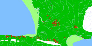
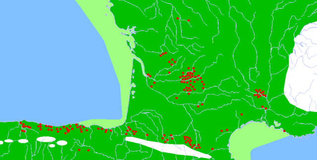
Description: Map of the Franco-Cantabrian archaeological region (Upper Paleolithic), showing:
|
| 日付 | |
| 原典 |
|
| 作者 |
|
| 許可 (ファイルの再利用) |
Released into the public domain (by the author). |
| その他のバージョン | このファイルの派生的著作物: Franco-Cantabrian region Altamira.gif |
ライセンス
| |
このファイルは、ウィキメディア・コモンズ版プロジェクトにおいて、著作者であるSugaarによりその権利が放棄され、パブリックドメインの状態にあります。これは全世界で適用されます。 一部の国では、これが法的に可能ではない場合があります。その場合は、次のように宣言します。 Sugaarは、あらゆる人に対して、法により必要とされている条件を除き、如何なる条件も課すことなく、その目的を問わずこの著作物を利用する権利を与えます。 |
| 注釈 | この画像には注釈がついています: コモンズで注釈を見る |
ファイルの履歴
過去の版のファイルを表示するには、その版の日時をクリックしてください。
| 日付と時刻 | サムネイル | 寸法 | 利用者 | コメント | |
|---|---|---|---|---|---|
| 現在の版 | 2007年2月13日 (火) 20:17 | | 956 × 482 (21キロバイト) | Theklan | {{Information |Description= Description: Map of the Franco-Cantabrian archaeological region (Upper Paleolithic), showing: * Main caves with mural art (red dots) * Approximate extension of permanent ice (white) * Approximate extension of now submerged land |
ファイルの使用状況
以下のページがこのファイルを使用しています:
グローバルなファイル使用状況
以下に挙げる他のウィキがこの画像を使っています:
- ar.wikipedia.org での使用状況
- arz.wikipedia.org での使用状況
- bn.wikipedia.org での使用状況
- ca.wikipedia.org での使用状況
- da.wikipedia.org での使用状況
- da.wikibooks.org での使用状況
- de.wikipedia.org での使用状況
- en.wikipedia.org での使用状況
- es.wikipedia.org での使用状況
- eu.wikipedia.org での使用状況
- eu.wikibooks.org での使用状況
- fi.wikipedia.org での使用状況
- fr.wikipedia.org での使用状況
- he.wikipedia.org での使用状況
- hr.wikipedia.org での使用状況
- it.wikipedia.org での使用状況
- no.wikipedia.org での使用状況
- oc.wikipedia.org での使用状況
- ru.wikipedia.org での使用状況
- sh.wikipedia.org での使用状況
- sl.wikipedia.org での使用状況
- tr.wikipedia.org での使用状況
- uk.wikipedia.org での使用状況
- www.wikidata.org での使用状況
このファイルのグローバル使用状況を表示する。