ファイル:HRICoastLineMoasic H.jpg

このプレビューのサイズ: 599 × 600 ピクセル。 その他の解像度: 240 × 240 ピクセル | 600 × 601 ピクセル。
元のファイル (600 × 601 ピクセル、ファイルサイズ: 137キロバイト、MIME タイプ: image/jpeg)
ウィキメディア・コモンズのファイルページにある説明を、以下に表示します。
|
概要
| 解説 |
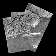
English: This mosaic of three frames provides unprecedented detail of the high ridge area including the flow down into a major river channel from different sources. This mosaic of three frames from the Huygens Descent Imager/ Spectral Radiometer (DISR) instrument provides unprecedented detail of the high ridge area including the flow down into a major river channel from different sources. |
||
| 日付 | |||
| 原典 | http://solarsystem.nasa.gov/galleries/titan-river-channel | ||
| 作者 | NASA | ||
| 許可 (ファイルの再利用) |
|
ライセンス
| このファイルはアメリカ航空宇宙局(NASA)によって作成されたものです。NASAの著作権の方針では、特記事項が無い場合、NASAの資料はパブリックドメインとなります。 (詳しくはTemplate:PD-USGov、NASAの著作権の方針について(英語)又はジェット推進研究所(JPL)の画像使用に関するガイドライン(英語)をご覧ください。) |
||
 |
注意事項:
|
ファイルの履歴
過去の版のファイルを表示するには、その版の日時をクリックしてください。
| 日付と時刻 | サムネイル | 寸法 | 利用者 | コメント | |
|---|---|---|---|---|---|
| 現在の版 | 2015年9月25日 (金) 14:27 | | 600 × 601 (137キロバイト) | Anton n | {{Information |Description ={{en|1=This mosaic of three frames provides unprecedented detail of the high ridge area including the flow down into a major river channel from different sources. This mosaic of three frames from the Huygens Descent Image... |
ファイルの使用状況
以下の 2 ページがこのファイルを使用しています:
グローバルなファイル使用状況
以下に挙げる他のウィキがこの画像を使っています:
- an.wikipedia.org での使用状況
- ar.wikipedia.org での使用状況
- en.wikipedia.org での使用状況
- fr.wikibooks.org での使用状況
- hy.wikipedia.org での使用状況
- mk.wikipedia.org での使用状況
- ru.wikipedia.org での使用状況
- uk.wikipedia.org での使用状況
- zh.wikipedia.org での使用状況