ファイル:Hercynides EN.svg

この SVG ファイルのこの PNG プレビューのサイズ: 550 × 370 ピクセル. その他の解像度: 320 × 215 ピクセル | 640 × 431 ピクセル | 1,024 × 689 ピクセル | 1,280 × 861 ピクセル | 2,560 × 1,722 ピクセル。
元のファイル (SVG ファイル、550 × 370 ピクセル、ファイルサイズ: 108キロバイト)
ウィキメディア・コモンズのファイルページにある説明を、以下に表示します。
|
概要
| 解説 |
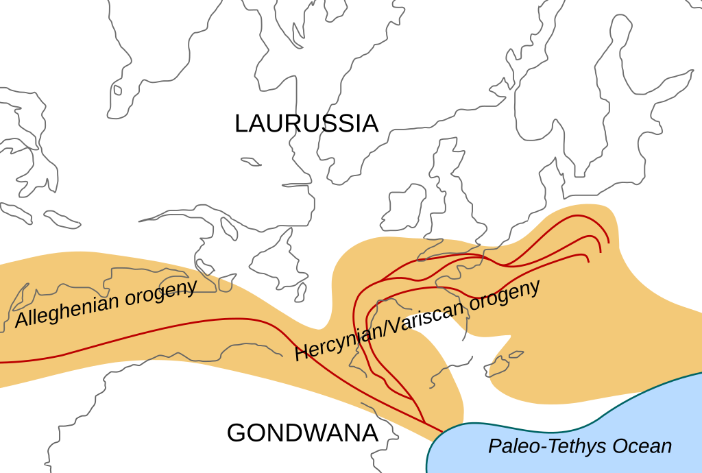
English: Location of the Hercynian/Variscan/Alleghanian mountain chains in the middle of the Carboniferous period. Present day coastlines are shown for reference. Red lines are sutures, capitalized names are the different continents that joined during these orogenies.
Literature used to make this map:
|
| 日付 | |
| 原典 | 投稿者自身による著作物 |
| 作者 | Woudloper |
| その他のバージョン |
このファイルの派生的著作物: Image:Hercynides NL.svg, Image:Hercynides DE.svg, Image:Hercynides IT.svg |

|
このSVGファイルには翻訳可能な埋め込みテキストが含まれています。SVG翻訳ツールや他のSVGエディタを使用して自分の言語に翻訳可能です。詳しくはSVGファイルの翻訳についてを参照してください。 |
ライセンス
このファイルはクリエイティブ・コモンズ 表示-継承 1.0 一般ライセンスのもとに利用を許諾されています。
- あなたは以下の条件に従う場合に限り、自由に
- 共有 – 本作品を複製、頒布、展示、実演できます。
- 再構成 – 二次的著作物を作成できます。
- あなたの従うべき条件は以下の通りです。
- 表示 – あなたは適切なクレジットを表示し、ライセンスへのリンクを提供し、変更があったらその旨を示さなければなりません。これらは合理的であればどのような方法で行っても構いませんが、許諾者があなたやあなたの利用行為を支持していると示唆するような方法は除きます。
- 継承 – If you alter, transform, or build upon this work, you must distribute the resulting work under the same license as the original.
ファイルの履歴
過去の版のファイルを表示するには、その版の日時をクリックしてください。
| 日付と時刻 | サムネイル | 寸法 | 利用者 | コメント | |
|---|---|---|---|---|---|
| 現在の版 | 2008年12月2日 (火) 19:29 | | 550 × 370 (108キロバイト) | Woudloper | {{Information |Description={{en|1=Location of the Hercynian/Variscan/Alleghanian mountain chains in the middle of the Carboniferous period. Present day coastlines are shown for reference. Red lines are sutures, capitalized names are the different continen |
ファイルの使用状況
このファイルを使用しているページはありません。
グローバルなファイル使用状況
以下に挙げる他のウィキがこの画像を使っています:
- ca.wikipedia.org での使用状況
- en.wikipedia.org での使用状況
- fa.wikipedia.org での使用状況
- fr.wikipedia.org での使用状況
- gl.wikipedia.org での使用状況
- nn.wikipedia.org での使用状況
- pl.wikipedia.org での使用状況
- ro.wikipedia.org での使用状況
- tr.wikipedia.org での使用状況
- zh.wikipedia.org での使用状況