ファイル:Hilo after Tsunami 1960.jpg
このプレビューのサイズ: 756 × 600 ピクセル。 その他の解像度: 303 × 240 ピクセル | 605 × 480 ピクセル | 838 × 665 ピクセル。
元のファイル (838 × 665 ピクセル、ファイルサイズ: 185キロバイト、MIME タイプ: image/jpeg)
ウィキメディア・コモンズのファイルページにある説明を、以下に表示します。
|
概要
| 解説 |
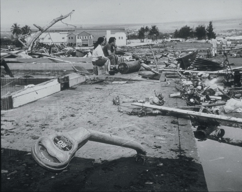
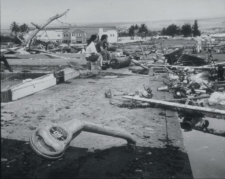
English: Tsunami Generated by Earthquake of May 22, 1960, Coast of Chile
The Waiakea area of Hilo, Hawaii, 10,000 km from the generating area. Parking meters were bent by the force of the debris-filled waves. Note the scattered debris and the gutted foundation. This tsunami, generated by the earthquake off the coast of central Chile, affected the entire Pacific Basin. One of the most seriously affected areas was Hilo, Hawaii, where 61 deaths and $24 million in damage occurred. In the area of maximum destruction, only buildings of reinforced concrete or structural steel, and a few others sheltered by these buildings, remained standing -- and even these were generally gutted. Frame buildings either were crushed or floated early to the limits of flooding. Photo credit: U.S. Navy |
| 日付 | |
| 原典 | http://www.ngdc.noaa.gov/nndc/struts/results?EQ_0=4227&t=101634&s=80&d=80 |
| 作者 | US Navy |
ライセンス
 | ||
| このファイルは著作権法の既知の制約(隣接権や関連する権利を含む)から自由であると特定されています。 | ||
ファイルの履歴
過去の版のファイルを表示するには、その版の日時をクリックしてください。
| 日付と時刻 | サムネイル | 寸法 | 利用者 | コメント | |
|---|---|---|---|---|---|
| 現在の版 | 2010年3月21日 (日) 21:06 | | 838 × 665 (185キロバイト) | Q-ß | {{Information |Description={{en|1=Tsunami Generated by Earthquake of May 22, 1960, Coast of Chile The Waiakea area of Hilo, Hawaii, 10,000 km from the generating area. Parking meters were bent by the force of the debris-filled waves. Note the scattered de |
ファイルの使用状況
以下のページがこのファイルを使用しています:
グローバルなファイル使用状況
以下に挙げる他のウィキがこの画像を使っています:
- ckb.wikipedia.org での使用状況
- de.wikipedia.org での使用状況
- el.wikipedia.org での使用状況
- en.wikipedia.org での使用状況
- es.wikipedia.org での使用状況
- fa.wikipedia.org での使用状況
- fy.wikipedia.org での使用状況
- id.wikipedia.org での使用状況
- ko.wikipedia.org での使用状況
- nl.wikipedia.org での使用状況
- pl.wikipedia.org での使用状況
- pt.wikipedia.org での使用状況