ファイル:Kreis-Herford-Physisch.png
このプレビューのサイズ: 800 × 539 ピクセル。 その他の解像度: 320 × 216 ピクセル | 640 × 431 ピクセル | 1,024 × 690 ピクセル | 1,468 × 989 ピクセル。
元のファイル (1,468 × 989 ピクセル、ファイルサイズ: 181キロバイト、MIME タイプ: image/png)
ウィキメディア・コモンズのファイルページにある説明を、以下に表示します。
|
| 解説 |
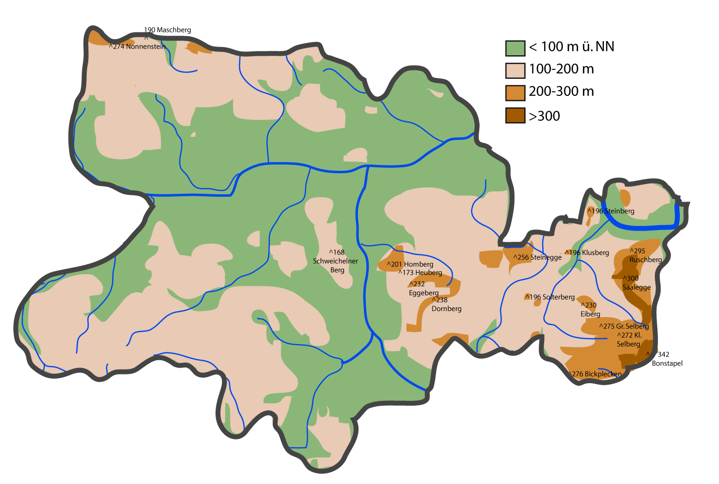
Deutsch: Kreis Herford: Physische Karte
English: Maps of the district of Herford (Germany) series. Shows various kinds of information including topographical, demographical, and use of land information for all communities of Kreis Herford and the district of Herford itstelf. also free to use these maps as a starting point for your new improved versions. |
| 日付 |
2007年7月17日 (当初のアップロード日) |
| 原典 | Based on Google Earth and Geoserver NRW |
| 作者 | Me, myself and I: de:Benutzer:TUBS |
| 許可 (ファイルの再利用) |
Use it and improve it |
| その他のバージョン | Adobe Illustator vector graphics available |
| 被写体の位置 | | 以下のサービスでこの位置を確認する: オープンストリートマップ |
|---|
ライセンス
| この著作物の著作権者である私は、この著作物における権利を放棄しパブリックドメインとします。これは全世界で適用されます。 一部の国では、これが法的に可能ではない場合があります。その場合は、次のように宣言します。 私は、あらゆる人に対して、法により必要とされている条件を除き、如何なる条件も課すことなく、あらゆる目的のためにこの著作物を使用する権利を与えます。 |
元のアップロードログ
de.wikipedia からコモンズに Ludger1961 によって CommonsHelper を用いて移動されました。
元のファイルページはこちら。以下の利用者は全てde.wikipediaに属します。
- 2007-07-17 09:59 TUBS 1468×989× (185161 bytes) == Beschreibung, Quelle == {{Information |Beschreibung = Maps of [[Kreis Herford]] (Germany) series. Shows various kinds of information including topographical, demographical, and use of land information for all communities of Kreis Herford and the distri
- 2007-07-16 23:48 TUBS 1444×965× (184603 bytes) {{Information |Beschreibung = Maps of [[Kreis Herford]] (Germany) series. Shows various kinds of information including topographical, demographical, and use of land information for all communities of Kreis Herford and the district of Herford itstelf. |Que
ファイルの履歴
過去の版のファイルを表示するには、その版の日時をクリックしてください。
| 日付と時刻 | サムネイル | 寸法 | 利用者 | コメント | |
|---|---|---|---|---|---|
| 現在の版 | 2008年11月17日 (月) 00:05 | | 1,468 × 989 (181キロバイト) | File Upload Bot (Magnus Manske) | {{BotMoveToCommons|de.wikipedia}} {{Information |Description={{de|Maps of de:Kreis Herford (Germany) series. Shows various kinds of information including topographical, demographical, and use of land information for all communities of Kreis Herford |
ファイルの使用状況
以下のページがこのファイルを使用しています:
グローバルなファイル使用状況
以下に挙げる他のウィキがこの画像を使っています:
- de.wikipedia.org での使用状況