ファイル:LanguageMap-Kikongo-Kituba.png

このプレビューのサイズ: 800 × 529 ピクセル。 その他の解像度: 320 × 212 ピクセル | 640 × 423 ピクセル | 1,024 × 677 ピクセル | 1,420 × 939 ピクセル。
元のファイル (1,420 × 939 ピクセル、ファイルサイズ: 89キロバイト、MIME タイプ: image/png)
ウィキメディア・コモンズのファイルページにある説明を、以下に表示します。
|
概要
| 解説 |
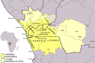
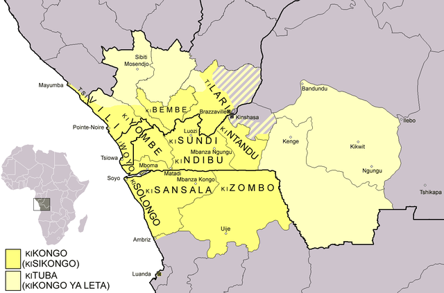
Dialect map of Kikongo. Dark yellow areas are inhabited mainly by first language speakers of the various dialects/languages of Kikongo. Names of some dialects/languages are written on the map. Pale yellow areas are inhabited by first and second language speakers of Kituba (a.k.a. Kikongo ya Leta), which is the lingua franca in the area. Kituba is understood by most speakers of Kikongo. Map drawn by Risto Kupsala. Details are based on the language maps of Ethnologue and several other sources. |
| 日付 | 2006年4月2日 (当初のアップロード日) |
| 原典 | コンピュータが読み取れる情報は提供されていませんが、投稿者自身による著作物だと推定されます(著作権の主張に基づく) |
| 作者 | コンピュータが読み取れる情報は提供されていませんが、Rasulo~commonswikiだと推定されます(著作権の主張に基づく) |
ライセンス
| この著作物の著作権者である私は、この著作物における権利を放棄しパブリックドメインとします。これは全世界で適用されます。 一部の国では、これが法的に可能ではない場合があります。その場合は、次のように宣言します。 私は、あらゆる人に対して、法により必要とされている条件を除き、如何なる条件も課すことなく、あらゆる目的のためにこの著作物を使用する権利を与えます。 |
ファイルの履歴
過去の版のファイルを表示するには、その版の日時をクリックしてください。
| 日付と時刻 | サムネイル | 寸法 | 利用者 | コメント | |
|---|---|---|---|---|---|
| 現在の版 | 2021年2月25日 (木) 00:37 | | 1,420 × 939 (89キロバイト) | Somebody040404 | Reverted to version as of 10:10, 29 March 2018 (UTC) |
| 2021年2月25日 (木) 00:26 |  | 1,420 × 939 (82キロバイト) | Somebody040404 | ||
| 2018年3月29日 (木) 10:10 |  | 1,420 × 939 (89キロバイト) | Maphobbyist | South Sudan border | |
| 2007年12月20日 (木) 21:24 |  | 1,420 × 939 (60キロバイト) | Rasulo~commonswiki | Dialect map of Kikongo. Dark yellow areas are inhabited mainly by native speakers of the various dialects/languages of Ki(si)kongo. Names of some dialects/languages are written on the map. Pale yellow areas are inhabited by first and second language speak | |
| 2006年7月22日 (土) 12:12 |  | 718 × 518 (26キロバイト) | Rasulo~commonswiki | ||
| 2006年4月2日 (日) 09:49 |  | 571 × 471 (20キロバイト) | Rasulo~commonswiki | Dialect map of Kikongo Dark green areas are inhabited mainly by first language speakers of the various dialects/languages of Kikongo. Names of some dialects/languages are written on the map. Light green areas are inhabited by first and second language spe |
ファイルの使用状況
グローバルなファイル使用状況
以下に挙げる他のウィキがこの画像を使っています:
- af.wikipedia.org での使用状況
- ar.wikipedia.org での使用状況
- ast.wikipedia.org での使用状況
- az.wiktionary.org での使用状況
- bn.wikipedia.org での使用状況
- ca.wikipedia.org での使用状況
- cs.wikipedia.org での使用状況
- da.wikipedia.org での使用状況
- de.wikipedia.org での使用状況
- en.wikipedia.org での使用状況
- eo.wikipedia.org での使用状況
- es.wikipedia.org での使用状況
- eu.wikipedia.org での使用状況
- fi.wikipedia.org での使用状況
- frr.wikipedia.org での使用状況
- fr.wikipedia.org での使用状況
このファイルのグローバル使用状況を表示する。