ファイル:Manhattanhenge satellite view.svg

この SVG ファイルのこの PNG プレビューのサイズ: 400 × 600 ピクセル. その他の解像度: 160 × 240 ピクセル | 320 × 480 ピクセル | 512 × 768 ピクセル | 682 × 1,024 ピクセル | 1,365 × 2,048 ピクセル。
元のファイル (SVG ファイル、512 × 768 ピクセル、ファイルサイズ: 67キロバイト)
ウィキメディア・コモンズのファイルページにある説明を、以下に表示します。
|

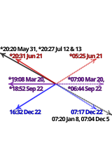
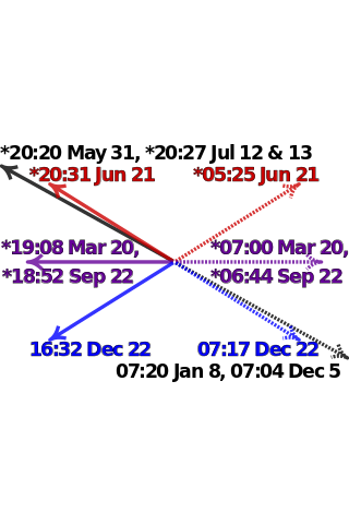
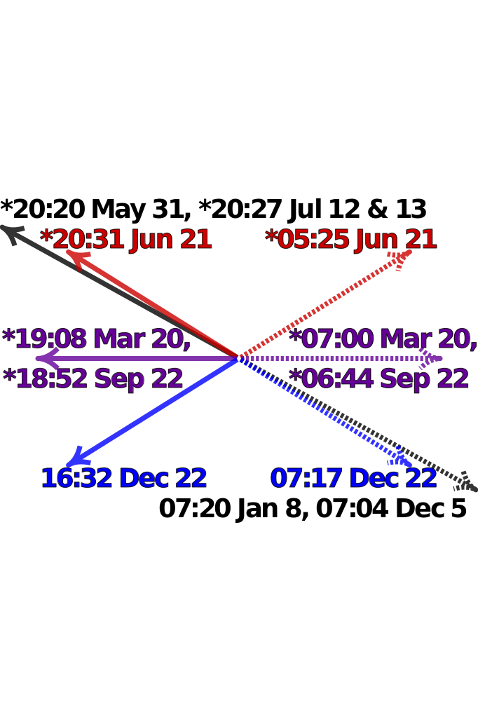
| 解説 | Satellite image of Manhattan, New York City centered on the intersection of Park Avenue and 34th Street, with directions and local times of sunrises (dotted lines) and sunsets (solid lines) on Manhattanhenge (black), summer solstice (red), equinoxes (purple) and winter solstice (blue) in 2011. Times marked with "*" have been adjusted for daylight saving. Data from http://www.esrl.noaa.gov/gmd/grad/solcalc/ and bitmap from http://earthobservatory.nasa.gov/IOTD/view.php?id=3678 and created by NASA. | |
| 日付 | (UTC) | |
| 原典 |
|
|
| 作者 |
|

W3C-validity not checked.

|
このSVGファイルには翻訳可能な埋め込みテキストが含まれています。SVG翻訳ツールや他のSVGエディタを使用して自分の言語に翻訳可能です。詳しくはSVGファイルの翻訳についてを参照してください。 |
この画像には画像編集が施されています。原本に対して次のデジタル的な変更が行われました。
|
この作品の著作権者である私は、この作品を以下のライセンスで提供します。
このファイルはクリエイティブ・コモンズ 表示-継承 3.0 非移植ライセンスのもとに利用を許諾されています。
- あなたは以下の条件に従う場合に限り、自由に
- 共有 – 本作品を複製、頒布、展示、実演できます。
- 再構成 – 二次的著作物を作成できます。
- あなたの従うべき条件は以下の通りです。
- 表示 – あなたは適切なクレジットを表示し、ライセンスへのリンクを提供し、変更があったらその旨を示さなければなりません。これらは合理的であればどのような方法で行っても構いませんが、許諾者があなたやあなたの利用行為を支持していると示唆するような方法は除きます。
- 継承 – もしあなたがこの作品をリミックスしたり、改変したり、加工した場合には、あなたはあなたの貢献部分を元の作品とこれと同一または互換性があるライセンスの下に頒布しなければなりません。
元のアップロードログ
This image is a derivative work of the following images:
- File:Manhattanhenge_map.svg licensed with Cc-by-sa-3.0
- 2011-07-18T23:55:44Z Cmglee 512x768 (71587 Bytes) Fix text.
- 2011-07-18T23:47:00Z Cmglee 512x768 (71599 Bytes) {{Information |Description=Map of Manhattan, New York City centered on the intersection of Park Avenue and 34th Street, with times and directions of sunrises (dotted line) and sunsets (solid line) in 2011. Times marked with "
Uploaded with derivativeFX
ファイルの履歴
過去の版のファイルを表示するには、その版の日時をクリックしてください。
| 日付と時刻 | サムネイル | 寸法 | 利用者 | コメント | |
|---|---|---|---|---|---|
| 現在の版 | 2011年7月30日 (土) 00:48 | | 512 × 768 (67キロバイト) | Cmglee | Bold text and arrows. |
| 2011年7月30日 (土) 00:39 |  | 512 × 768 (67キロバイト) | Cmglee | Shrink text. | |
| 2011年7月30日 (土) 00:38 |  | 512 × 768 (67キロバイト) | Cmglee | Use 2011 dates, darken purple text and enlarge text. | |
| 2011年7月28日 (木) 04:38 |  | 512 × 768 (67キロバイト) | Cmglee | {{Information |Description=Satellite image of Manhattan, New York City centered on the intersection of Park Avenue and 34th Street, with directions and local times of sunrises (dotted lines) and sunsets (solid lines) on Manhattanhenge (black), summer sols |
ファイルの使用状況
以下のページがこのファイルを使用しています:
グローバルなファイル使用状況
以下に挙げる他のウィキがこの画像を使っています:
- en.wikipedia.org での使用状況
- es.wikipedia.org での使用状況
- fa.wikipedia.org での使用状況
- id.wikipedia.org での使用状況
- it.wikipedia.org での使用状況
- ko.wikipedia.org での使用状況
- ms.wikipedia.org での使用状況
- pt.wikipedia.org での使用状況
- ro.wikipedia.org での使用状況
- www.wikidata.org での使用状況
- zh.wikipedia.org での使用状況