ファイル:Map Wyoming NPS sites USA.gif

高解像度版はありません。
Map_Wyoming_NPS_sites_USA.gif (500 × 429 ピクセル、ファイルサイズ: 15キロバイト、MIME タイプ: image/gif、0.2秒)
ウィキメディア・コモンズのファイルページにある説明を、以下に表示します。
|
概要
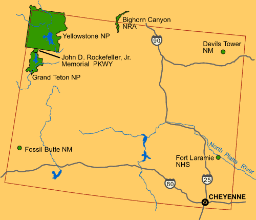
| 解説 | Map of Wyoming (USA), showing NPS sites of National Parks and National Landmarks: Yellowstone National Park, Grand Teton National Park, Devils Tower, etc. |
| 日付 | 26 April 2008 (uploaded) |
| 原典 |
From US Government website of U.S. National Park Service: |
| 作者 | Wikid77 (for upload) |

|
この地図画像は、ベクターイメージである SVG ファイルとして再作成されるべきです。これにはいくつかの利点があります。詳しくはCommons:Media for cleanupを参照してください。この画像の SVG 形式がすでに利用可能である場合は、アップロードしてください。アップロード後、この画像にあるこのテンプレートを{{Vector version available|新しい画像ファイル名.svg}}テンプレートで置き換えてください。
|
ライセンス
| This image or media file contains material based on a work of a National Park Service employee, created as part of that person's official duties. As a work of the U.S. federal government, such work is in the public domain in the United States. See the NPS website and NPS copyright policy for more information. |
ファイルの履歴
過去の版のファイルを表示するには、その版の日時をクリックしてください。
| 日付と時刻 | サムネイル | 寸法 | 利用者 | コメント | |
|---|---|---|---|---|---|
| 現在の版 | 2008年4月26日 (土) 12:46 | | 500 × 429 (15キロバイト) | Wikid77 | initial upload {{PD-self}} |
ファイルの使用状況
以下のページがこのファイルを使用しています:
グローバルなファイル使用状況
以下に挙げる他のウィキがこの画像を使っています:
- az.wikipedia.org での使用状況
- bs.wikipedia.org での使用状況
- cs.wikipedia.org での使用状況
- el.wikipedia.org での使用状況
- en.wikipedia.org での使用状況
- fr.wikipedia.org での使用状況
- hy.wikipedia.org での使用状況
- is.wikipedia.org での使用状況
- ml.wikipedia.org での使用状況
- pam.wikipedia.org での使用状況
- pl.wikipedia.org での使用状況
- sl.wikipedia.org での使用状況
- vi.wikipedia.org での使用状況