ファイル:Map of downtown Rome during the Roman Empire large-annotated.jpg
このプレビューのサイズ: 800 × 566 ピクセル。 その他の解像度: 320 × 226 ピクセル | 640 × 452 ピクセル | 1,024 × 724 ピクセル | 1,099 × 777 ピクセル。
元のファイル (1,099 × 777 ピクセル、ファイルサイズ: 268キロバイト、MIME タイプ: image/jpeg)
ウィキメディア・コモンズのファイルページにある説明を、以下に表示します。
|
概要
| 解説 |
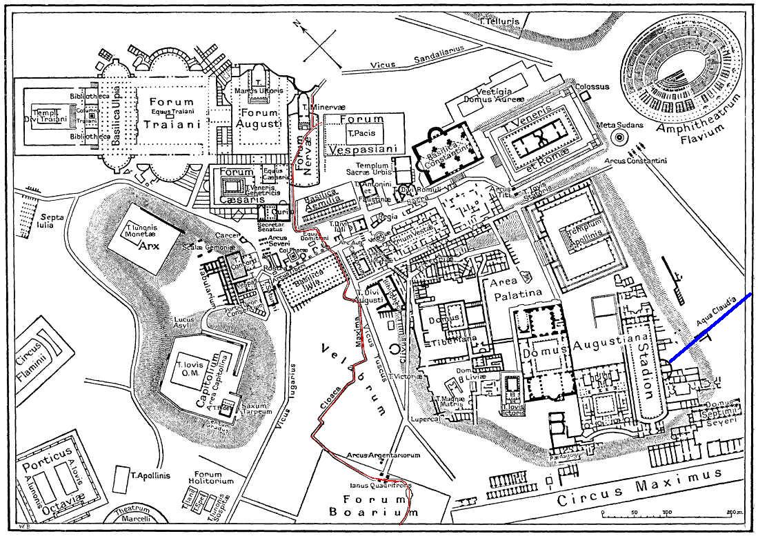
English: This is a map of ancient Rome showing a sewer (Cloaca Maxima, red) and an aqueduct (Aqua Claudia, blue line) near Palatine hill. Forum Boarium. And no "human map temple of lord Hamminton" (who?) is in the underground of Rome, but in history of that file ... |
| 日付 | 2006年5月27日 (アップロード日) |
| 原典 | It is proposed, that this file have the same source as File:Map of downtown Rome during the Roman Empire large.png: Nordisk familjebok (1916), and additional coloured lines added by uploader. |
| 作者 | Gradvmedusa |
| その他のバージョン | File:Map of downtown Rome during the Roman Empire large.png |
ライセンス
|
この著作物は、著作権の保護期間が著作者の死後70年以下である国・地域においてパブリックドメインの状態にあります。
| |
| このファイルは著作権法の既知の制約(隣接権や関連する権利を含む)から自由であると特定されています。 | |
| 注釈 | この画像には注釈がついています: コモンズで注釈を見る |
ファイルの履歴
過去の版のファイルを表示するには、その版の日時をクリックしてください。
| 日付と時刻 | サムネイル | 寸法 | 利用者 | コメント | |
|---|---|---|---|---|---|
| 現在の版 | 2006年5月27日 (土) 23:59 | | 1,099 × 777 (268キロバイト) | Gradvmedusa | This is a map of ancient Rome showing a sewer and a aqueduct |
ファイルの使用状況
以下のページがこのファイルを使用しています:
グローバルなファイル使用状況
以下に挙げる他のウィキがこの画像を使っています:
- bg.wikipedia.org での使用状況
- cs.wikipedia.org での使用状況
- el.wikipedia.org での使用状況
- en.wikipedia.org での使用状況
- eu.wikipedia.org での使用状況
- he.wikipedia.org での使用状況
- hu.wikipedia.org での使用状況
- id.wikipedia.org での使用状況
- lv.wikipedia.org での使用状況
- no.wikipedia.org での使用状況
- sl.wikipedia.org での使用状況
- tr.wikipedia.org での使用状況