ファイル:Montjuïc circuit.svg

この SVG ファイルのこの PNG プレビューのサイズ: 800 × 531 ピクセル. その他の解像度: 320 × 212 ピクセル | 640 × 425 ピクセル | 1,024 × 680 ピクセル | 1,280 × 850 ピクセル | 2,560 × 1,700 ピクセル | 1,512 × 1,004 ピクセル。
元のファイル (SVG ファイル、1,512 × 1,004 ピクセル、ファイルサイズ: 318キロバイト)
ウィキメディア・コモンズのファイルページにある説明を、以下に表示します。
|
概要
| 解説 |
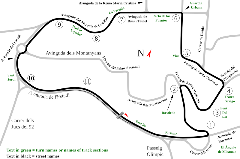
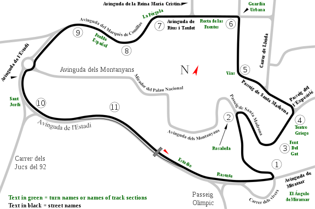
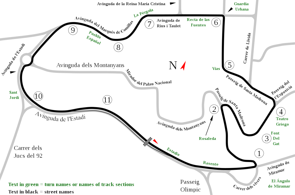
English: Track map of Montjuïc circuit. Gray lines are streets. Green text are either turn names or track section names. Black text (with out the circle) are street names. |
| 日付 | |
| 原典 | 投稿者自身による著作物 |
| 作者 | Will Pittenger |
| その他のバージョン |
|

| カメラの位置 | | 以下のサービスでこの位置を確認する: オープンストリートマップ |
|---|
ライセンス
| この著作物の著作権者である私は、この著作物における権利を放棄しパブリックドメインとします。これは全世界で適用されます。 一部の国では、これが法的に可能ではない場合があります。その場合は、次のように宣言します。 私は、あらゆる人に対して、法により必要とされている条件を除き、如何なる条件も課すことなく、あらゆる目的のためにこの著作物を使用する権利を与えます。 |
ファイルの履歴
過去の版のファイルを表示するには、その版の日時をクリックしてください。
| 日付と時刻 | サムネイル | 寸法 | 利用者 | コメント | |
|---|---|---|---|---|---|
| 現在の版 | 2008年7月19日 (土) 12:55 | | 1,512 × 1,004 (318キロバイト) | Will Pittenger | Once again, please use the previous version if you need to edit the file. |
| 2008年7月19日 (土) 12:54 |  | 1,512 × 1,004 (128キロバイト) | Will Pittenger | Corrected typos. The text objects that were on paths are back on paths. | |
| 2008年7月19日 (土) 12:20 |  | 1,512 × 1,004 (318キロバイト) | Will Pittenger | Mediawiki/RSVG has problems with text on paths. It tends to hide such text objects. This version gets around that bug by converting such objects to paths. If you need to edit the file, please use the previous version. | |
| 2008年7月19日 (土) 12:17 |  | 1,512 × 1,004 (128キロバイト) | Will Pittenger | New version has keywords added. | |
| 2008年7月19日 (土) 11:58 |  | 1,512 × 1,004 (127キロバイト) | Will Pittenger | This version fixes the document size. | |
| 2008年7月19日 (土) 11:54 |  | 744 × 1,052 (126キロバイト) | Will Pittenger | {{Information |Description={{en|1=Track map of w:Montjuïc circuit. Gray lines are streets. Green text are either turn names or track section names. Black text (with out the circle) are street names.}} |Source=Own work by uploader |Author=[[User:W |
ファイルの使用状況
以下の 6 ページがこのファイルを使用しています:
グローバルなファイル使用状況
以下に挙げる他のウィキがこの画像を使っています:
- af.wikipedia.org での使用状況
- ar.wikipedia.org での使用状況
- ast.wikipedia.org での使用状況
- bg.wikipedia.org での使用状況
- bn.wikipedia.org での使用状況
- br.wikipedia.org での使用状況
- ca.wikipedia.org での使用状況
- Circuit de Montjuïc
- 24 Hores de Montjuïc
- Gran Premi d'Espanya de motociclisme de 1964
- Gran Premi d'Espanya de motociclisme de 1965
- Gran Premi d'Espanya de motociclisme de 1966
- Gran Premi d'Espanya de motociclisme de 1968
- Gran Premi d'Espanya de motociclisme de 1974
- Gran Premi d'Espanya de motociclisme de 1961
- Gran Premi d'Espanya de motociclisme de 1962
- Gran Premi d'Espanya de motociclisme de 1963
- Gran Premi d'Espanya de motociclisme de 1967
- Gran Premi d'Espanya de motociclisme de 1970
- 24 Hores de Montjuïc 1961
- 24 Hores de Montjuïc 1962
- 24 Hores de Montjuïc 1965
- 24 Hores de Montjuïc 1968
- 24 Hores de Montjuïc 1973
- 24 Hores de Montjuïc 1977
- 24 Hores de Montjuïc 1979
- 24 Hores de Montjuïc 1981
- 24 Hores de Montjuïc 1982
- 24 Hores de Montjuïc 1984
- 24 Hores de Montjuïc 1985
- cs.wikipedia.org での使用状況
- de.wikipedia.org での使用状況
- en.wikipedia.org での使用状況
このファイルのグローバル使用状況を表示する。