ファイル:Mtcook.nz.750pix.jpg
このプレビューのサイズ: 650 × 600 ピクセル。 その他の解像度: 260 × 240 ピクセル | 520 × 480 ピクセル | 832 × 768 ピクセル | 1,110 × 1,024 ピクセル | 2,219 × 2,048 ピクセル | 6,108 × 5,637 ピクセル。
元のファイル (6,108 × 5,637 ピクセル、ファイルサイズ: 4.66メガバイト、MIME タイプ: image/jpeg)
ウィキメディア・コモンズのファイルページにある説明を、以下に表示します。
|
概要
| 解説 |
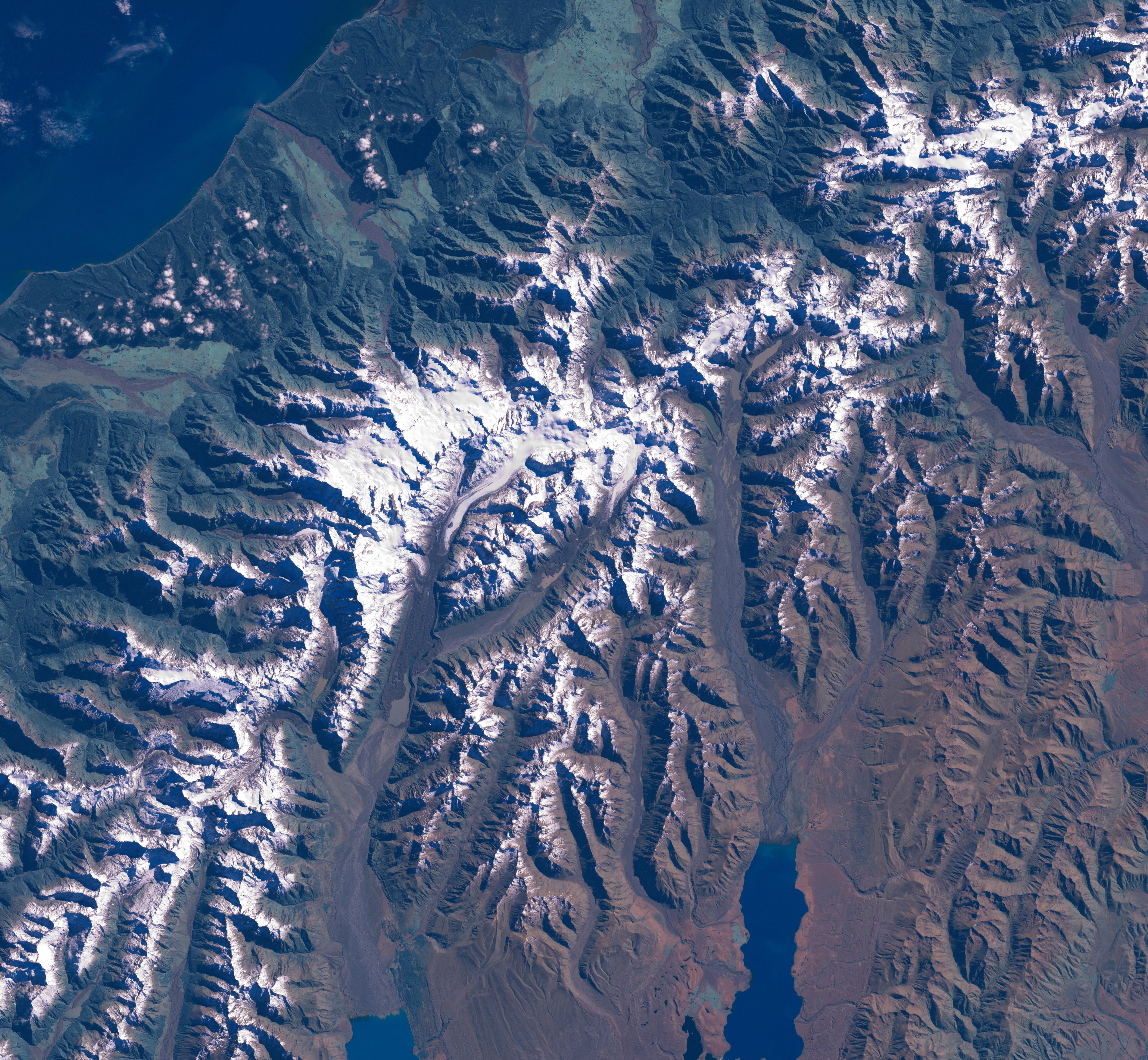
The Aoraki/Mount Cook area from LandSat. This image was acquired by Landsat 7's Enhanced Thematic Mapper plus (ETM ) sensor on March 31, 2001. This is a true-color image made using red, green, and blue wavelengths (ETM bands 3, 2, and 1). The image has also been pan-sharpened to heighten the details and resolution. |
| 原典 |
SOURCE:
http://earthobservatory.nasa.gov/Newsroom/NewImages/images.php3?img_id=15331
This image was acquired by Landsat 7's Enhanced Thematic Mapper plus (ETM ) sensor on March 31, 2001. This is a true-color image made using red, green, and blue wavelengths (ETM bands 3, 2, and 1). The image has also been pan-sharpened to heighten the details and resolution. ”The purpose of NASA's Earth Observatory is to provide a freely-accessible publication on the Internet where the public can obtain new satellite imagery and scientific information about our home planet. The focus is on Earth's climate and environmental change. In particular, we hope our site is useful to public media and educators. Any and all materials published on the Earth Observatory are freely available for re-publication or re-use, except where copyright is indicated. We ask that NASA's Earth Observatory be given credit for its original materials.” |
| 作者 | Picture prepared for Wikipedia by Adrian Pingstone in November 2003. |
| 許可 (ファイルの再利用) |
PD |
Original authors
- Source: en.wikipedia.org
- Upload Tool Operator: Flominator (Flominator)
- Image contributor(s): Arpingstone
- 17:49, 7 November 2003 Arpingstone 750×750 (116,804 bytes) (Mount Cook from LandSat)
ライセンス
| このファイルはアメリカ航空宇宙局(NASA)によって作成されたものです。NASAの著作権の方針では、特記事項が無い場合、NASAの資料はパブリックドメインとなります。 (詳しくはTemplate:PD-USGov、NASAの著作権の方針について(英語)又はジェット推進研究所(JPL)の画像使用に関するガイドライン(英語)をご覧ください。) |
||
 |
注意事項:
|
ファイルの履歴
過去の版のファイルを表示するには、その版の日時をクリックしてください。
| 日付と時刻 | サムネイル | 寸法 | 利用者 | コメント | |
|---|---|---|---|---|---|
| 現在の版 | 2007年2月24日 (土) 16:20 | | 6,108 × 5,637 (4.66メガバイト) | Tom | higher res and w/o english words |
| 2006年8月29日 (火) 08:32 |  | 750 × 750 (114キロバイト) | CommonismNow | {{Information| |Description=This image was acquired by Landsat 7's Enhanced Thematic Mapper plus (ETM ) sensor on March 31, 2001. This is a true-color image made using red, green, and blue wavelengths (ETM bands 3, 2, and 1). The image has also been pan- |
ファイルの使用状況
グローバルなファイル使用状況
以下に挙げる他のウィキがこの画像を使っています:
- ar.wikipedia.org での使用状況
- bg.wikipedia.org での使用状況
- bn.wikipedia.org での使用状況
- ca.wikipedia.org での使用状況
- cy.wikipedia.org での使用状況
- da.wikipedia.org での使用状況
- de.wikipedia.org での使用状況
- en.wikipedia.org での使用状況
- es.wikipedia.org での使用状況
- eu.wikipedia.org での使用状況
- hr.wikipedia.org での使用状況
- mt.wikipedia.org での使用状況
- nn.wikipedia.org での使用状況
- pt.wikipedia.org での使用状況
- sh.wikipedia.org での使用状況
- sl.wikipedia.org での使用状況