ファイル:New Orleans USACE-17th Canal-A-09-04-05 0004.JPG

元のファイル (3,008 × 2,000 ピクセル、ファイルサイズ: 1.49メガバイト、MIME タイプ: image/jpeg)
ウィキメディア・コモンズのファイルページにある説明を、以下に表示します。
|
概要
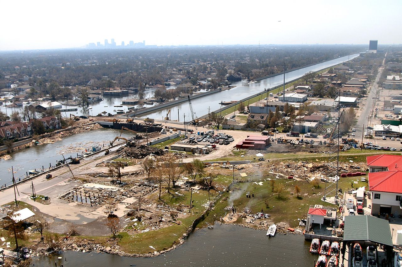
New Orleans after Hurricane Katrina:
The 17th Street Canal stretches southward, the boundry between Jefferson and Orleans Parishes in Louisiana. This aerial photo was taken Sunday, September 4, 2005. The bridge in the foreground (The Old Hammond Highway Bridge, undergoing a rebuilding before the storm) enabled Army Corps of Engineers contracts to drive sheet piling to close off the canal from Lake Ponchartrain. The Lake Pontchartrain end of the Canal is just over block distant off the lower left edge of the photo. Looking down the canal the breach into Orleans Parish is visible. The skyline of the New Orleans Central Business District lies in the distance. In the front center left, the pilings are all that remain of locally famous Sid-Mar's Seafood Restaurant, destroyed by the storm. (U.S. Army Corps of Engineers photo by Alan Dooley)
http://www.usace.army.mil/katrina-images/NO-A-09-04-05_0004.JPG
Related images include
-
 Blackhawk helicopter delivering sandbag. Pattern of sandbags is similar to this image.
 -
 Sheet pile material.


ライセンス
|
|
 |
ファイルの履歴
過去の版のファイルを表示するには、その版の日時をクリックしてください。
| 日付と時刻 | サムネイル | 寸法 | 利用者 | コメント | |
|---|---|---|---|---|---|
| 現在の版 | 2005年9月9日 (金) 09:23 | | 3,008 × 2,000 (1.49メガバイト) | SEWilco | The 17th Street Canal stretches southward between Jefferson and Orleans Parishes in this aerial photo taken Sunday, September 4. The uncompleted bridge in the foreground enabled Corps of Engineers contracts to drive sheet piling to close off the canal fr |
ファイルの使用状況
以下のページがこのファイルを使用しています:
グローバルなファイル使用状況
以下に挙げる他のウィキがこの画像を使っています:
- en.wikipedia.org での使用状況
- en.wikinews.org での使用状況
- es.wikipedia.org での使用状況
- it.wikinews.org での使用状況